
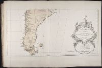
You Searched For
« Previous
| 1 - 10 of 13 |
Next »
Search Results


- Creator:
- Anville, Jean Baptiste Bourguignon d', 1697-1782
Kitchin, Thomas, d. 1784
Sayer, Robert, 1725-1794, creator - Published / Created:
- 1787 July 1
- Call Number:
- 1982 Folio 10
- Image Count:
- 2
- Description:
- Also appeared in Kitchin's General atlas describing the whole universe. London : Printed for Robert Sayer, [1780]., Includes descriptive notes and text "Division of South America with a summary account of its trade," and large ornamental cartouche., Inset map: Chart of the Falkland's Islands : named by the French Malouine Islands, and discovered by Hawkins in the year 1595. Scale [ca. 1:2,000,000]., No. 43 of 43 maps bound together in composite atlas., Prime meridian: Ferro., Relief shown pictorially; depths by soundings., Scale [ca. 1:7,900,000]., and Sheets mounted together to form 2 sheets.
- Publisher:
- Printed for Robert Sayer
- Subject (Geographic):
- Falkland Islands --Maps --Early works to 1800 and South America --Maps --Early works to 1800
- Found in:
- Beinecke Rare Book and Manuscript Library > A map of South America : containing Tierra-Firma, Guayana, New Granada, Amazonia, Brasil, Peru, Paraguay, Chaco, Tucuman, Chili and Patagonia : from Mr. d'Anville with several improvements and additions, and the newest discoveries
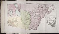
3.

- Creator:
- Anville, Jean Baptiste Bourguignon d', 1697-1782
Pownall, Thomas, 1722-1805
Sayer, Robert, 1725-1794, creator - Published / Created:
- 1786
- Call Number:
- 1982 Folio 10
- Image Count:
- 2
- Description:
- Compiled from Mr. D'Anville's maps of that continent, with the addition of the Spanish discoveries in 1775 to the north of California & corrected in the several parts belonging to Great Britain from the original materials of Governor Pownall, M.P., From Thomas Kitchin's a general atlas describing the whole universe. [1793]., Includes inset The supplement to North America containing the countries adjoining to Baffins & Hudsons Bays and tables showing European possessions., No. 39 of 43 maps bound together in composite atlas., Prime meridian: Ferro., Relief shown pictorially., and Scale [ca. 1:11,500,000].
- Publisher:
- Printed for Robt. Sayer, map, chart & printseller
- Subject (Geographic):
- United States --Maps --Early works to 1800 and Western Hemisphere --Maps --Early works to 1800
- Found in:
- Beinecke Rare Book and Manuscript Library > A new map of the whole continent of America : divided into North and South and West Indies wherein are exactly described the United States of North America as well as the several European possessions according to the preliminaries of peace signed at Versa
4.

- Creator:
- Anville, Jean Baptiste Bourguignon d', 1697-1782
Boulton, S., creator
Sayer, Robert, 1725-1794 - Published / Created:
- 1787 January 6
- Call Number:
- 1982 Folio 10
- Image Count:
- 2
- Description:
- Also appeared in Kitchin's General atlas describing the whole universe. London : Printed for Robert Sayer, [1780]., By S. Boulton ; and also a summary description relative to the trade and natural produce, manners and customs of the African continent and islands., Insets: A particular chart of the Gold Cost. -- Azores or Western Islands., No. 35 of 43 maps bound together in composite atlas., Scale [ca. 1:8,500,000]., Sheets pasted together to create 1 map on 2 sheets., and With descriptive text.
- Publisher:
- Printed for Robert Sayer
- Subject (Geographic):
- Africa --Maps --Early works to 1800 and Ghana --Maps --Early works to 1800
- Found in:
- Beinecke Rare Book and Manuscript Library > Africa : with all its states, kingdoms, republics, regions, islands, & ca., improved and inlarged from D'Anville's map : to which have been added a particular chart of the Gold Coast wherein are distinguished all the European forts and factories
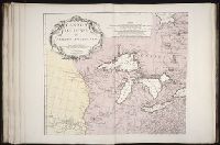
- Creator:
- Anville, Jean Baptiste Bourguignon d', 1697-1782
Gravelot, Sr
Major, Sr - Published / Created:
- 1746
- Call Number:
- 2003 Folio 85
- Image Count:
- 1
- Description:
- Inset map: [Hudson Bay-Labrador Region]. and No. 2 of 45 maps bound together with binder’s spine title: Atlas of America; ms. table of contents. Bookplate of Paul Mellon.
- Publisher:
- Chez l'auteur, aux Galeries du Louvre
- Subject (Geographic):
- South America -- Maps -- Early works to 1800
- Found in:
- Beinecke Rare Book and Manuscript Library > Amerique Septentrionale: publiee sous les auspices de Monseigneur le Duc d'Orleans preÌÎåmier prince du sang / par le Sr. D'Anville
6.
- Creator:
- Anville, Jean Baptiste Bourguignon d', 1697-1782
Haye, G. de la - Published / Created:
- avec privilege 1748
- Call Number:
- 2003 Folio 85
- Image Count:
- 1
- Description:
- Hand colored., 2003 Folio 85: No. 43 of 45 maps bound together with binder’s spine title: Atlas of America, Bookplate: Robinson. Bookplate of Paul Mellon, Relief shown pictorially., and Scale [ca. 1:2,500,000]
- Publisher:
- Chez l’auteur, aux Galeries du Louvre
- Subject (Geographic):
- South America --Maps --Early works to 1800
- Found in:
- Beinecke Rare Book and Manuscript Library > Amerique meridionale : publiee sous les auspices de Monseigneur le Duc d'Orleans preå«mier prince du sang / par le Sr. D'Anville
7.

- Creator:
- Anville, Jean Baptiste Bourguignon d', 1697-1782
Cook, James, 1728-1779
Kitchin, Thomas, d. 1784, creator
Sayer, Robert, 1725-1794 - Published / Created:
- 1787 January 6
- Call Number:
- 1982 Folio 10
- Image Count:
- 2
- Description:
- Also appeared in Kitchin's General atlas describing the whole universe. London : Printed for Robert Sayer, [1780]., No. 29 of 43 maps bound together in composite atlas., Relief shown pictorially., Scale [ca. 1:11,100,000]., Sheets mounted together to form 2 sheets., Shows boundaries, rivers, settlements, islands; includes descriptive notes., and Title cartouche depicts local produce, a palm tree and a camel.
- Publisher:
- Printed for Robert Sayer
- Subject (Geographic):
- Asia --Maps --Early works to 1800
- Found in:
- Beinecke Rare Book and Manuscript Library > Asia and its islands according to d'Anville : divided into empires, kingdoms, states, regions, & ca. with the European possessions and settlements in the East Indies and an exact delineation of all the discoveries made in the eastern parts by the English
- Creator:
- Anville, Jean Baptiste Bourguignon d', 1697-1782
Haye, G. de la - Published / Created:
- Novembre 1755
- Call Number:
- 2003 Folio 85
- Image Count:
- 1
- Description:
- BEIN 2003 Folio 85: No. 3 of 45 maps bound together with binder's spine title: Atlas of America; ms. table of contents. Bookplate: Robinson. Bookplate of Paul Mellon., From the author's Atlas general. 1743-80., Hand colored., Has watermarks., National Maritime Museum. Catalog,, par le Sr. d'Anville ... ; [Gravee par] G. De-La-Haye., Relief shown pictorially., Scale [ca. 1:2,750,000]., and Sous le privilege de l'Academie.
- Publisher:
- Chez l'auteur, aux galeries du Louvre
- Subject (Geographic):
- Canada -- Maps -- Early works to 1800, Louisiana -- Maps -- Early works to 1800, and North America -- Maps -- Early works to 1800
- Found in:
- Beinecke Rare Book and Manuscript Library > Canada, Louisiane et terres angloises
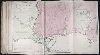
- Creator:
- Anville, Jean Baptiste Bourguignon d', 1697-1782
- Published / Created:
- [1752]
- Call Number:
- 2003 Folio 85
- Image Count:
- 1
- Description:
- BEIN 2003 Folio 85: No. 25 of 45 maps bound together with binder's spine title: Atlas of America; ms. table of contents. Bookplate: Robinson. Bookplate of Paul Mellon., Hand colored., par le sr. d'Anville ; dresse en Mai 1732 ; publiee en 1752, and Scale [ca. 1:940,000].
- Publisher:
- Guill? de la Haye
- Subject (Geographic):
- Louisiana -- Maps -- Early works to 1800
- Found in:
- Beinecke Rare Book and Manuscript Library > Carte de la Louisiane

- Creator:
- Anville, Jean Baptiste Bourguignon d', 1697-1782
- Published / Created:
- 1765
- Call Number:
- 1982 Folio 10
- Image Count:
- 1
- Description:
- Ferro meridian., No. 38 of 43 maps bound together in composite atlas., Relief shown by hachures., Scale [1:1,750,000]., and Shows rivers and settlements.
- Subject (Geographic):
- Egypt --Maps --Early works to 1800 and Nile River --Maps --Early works to 1800
- Found in:
- Beinecke Rare Book and Manuscript Library > Egypt : called in the country Missir