Search
You Searched For
Search Results
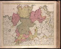
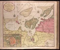
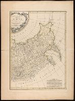
- Creator:
- Valck, G. (Gerard), 1651 or 1652-1726.
- Published / Created:
- ca. 1702?]
- Call Number:
- 1973 Folio 18
- Image Count:
- 1
- Resource Type:
- Maps, Atlases & Globes
- Description:
- cm. No. 22 of 87 maps bound together.
- Subject (Geographic):
- Germany, Northern--Maps--Early works to
- Found in:
- Beinecke Rare Book and Manuscript Library > Circulus Saxoniae Inferioris, divisa in ducatus Brunsuici, Zellae, Holsatiae, Meklenburgi et Bremae, archiepiscopatum Magdeburgi, et episcopatus Hildesii et Halberstadii [cartographic material] / per Gerardi et Leonardi Valk, cum privilegio.
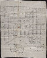
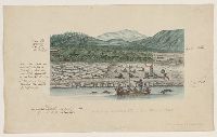
- Published / Created:
- 1847 February 22
- Call Number:
- WA MSS S-1882
- Image Count:
- 1
- Resource Type:
- Maps, Atlases & Globes
- Abstract:
- Autograph manuscript map, drawn on
- Description:
- Map has been repaired with two pieces
- Subject (Geographic):
- San Francisco (Calif.) --Maps
- Found in:
- Beinecke Rare Book and Manuscript Library > Map of San Francisco, Calif., 1847
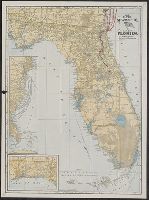
- Creator:
- C.S. Hammond & Company
- Published / Created:
- c1903.
- Call Number:
- 792 1903
- Container / Volume:
- BRBL_00519
- Image Count:
- 2
- Resource Type:
- Maps, Atlases & Globes
- Alternative Title:
- Hammonds 16 x 22 map of Florida
- Subject (Geographic):
- Florida--Maps
- Subject (Topic):
- Railroads--Florida--Maps
- Found in:
- Beinecke Rare Book and Manuscript Library > The Clyde Steamship Co. map of Florida : showing routes and railroad connections.
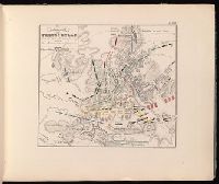
- Creator:
- Jomini, Antoine Henri, baron de, 1779-1869
- Published / Created:
- [1840?]
- Call Number:
- 2002 Folio 32
- Image Count:
- 1
- Description:
- de 22 aôut, 1852, Belgique, France
- Subject (Geographic):
- France--History--Revolution--Maps
- Found in:
- Beinecke Rare Book and Manuscript Library > Atlas portatif pour l'intelligence des relations des dernières guerres : publiées sans plans ; notamment pour la vie de Napoléon.
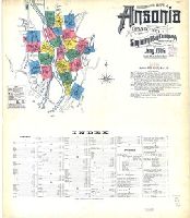
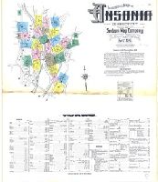
- Creator:
- Sanborn Map Company, issuing body
- Published / Created:
- 1906
- Call Number:
- 766 An81 1906
- Image Count:
- 22
- Resource Type:
- Maps, Atlases & Globes
- Abstract:
- Sanborn fire insurance maps are a rich
- Description:
- "22 sheets (8531)."
- Subject (Geographic):
- Ansonia (Conn.)--Maps
- Subject (Name):
- Library of Congress. Map Divison Stamp
- Subject (Topic):
- --Ansonia--Maps
- Found in:
- Beinecke Rare Book and Manuscript Library > Insurance maps of Ansonia, Connecticut, New Haven County.
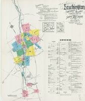
- Creator:
- Sanborn Map Company, issuing body
- Published / Created:
- 1923
- Call Number:
- 766 So87 1923
- Image Count:
- 22
- Resource Type:
- Maps, Atlases & Globes
- Abstract:
- Sanborn fire insurance maps are a rich
- Description:
- "22 sheets. (5907)."
- Subject (Geographic):
- Southington (Conn.)--Maps
- Subject (Topic):
- --Southington--Maps
- Found in:
- Beinecke Rare Book and Manuscript Library > Southington, including Plantsville and Milldale, Hartford County, Connecticut.
- Creator:
- Seale, Richard William
- Published / Created:
- [1783?]
- Call Number:
- 1977 Folio 177
- Image Count:
- 4
- Resource Type:
- Maps, Atlases & Globes
- Description:
- measure 70.0 x 50.5 cm or smaller. No. 22 of
- Subject (Geographic):
- Great Britain--Maps--Early works to
- Found in:
- Beinecke Rare Book and Manuscript Library > England and Ireland : containing all the cities, boroughs, markettowns & principal villages : with the coast of France from Calais to Brest delineated and engraved from actual surveys / by Richard William Seale.
- Creator:
- Blanchard, Joseph, d. 1758
- Published / Created:
- 1761
- Call Number:
- 762 1761
- Container / Volume:
- BRBL_00450
- Image Count:
- 2
- Resource Type:
- Maps, Atlases & Globes
- Description:
- topography of North America. 1768. no. 22, plates
- Found in:
- Beinecke Rare Book and Manuscript Library > An accurate map of His Majesty's Province of New-Hampshire in New England, taken from actual surveys of all the inhabited part, and from the best information of what is uninhabited, together with the adjacent countries, which exhibits the theatre of this
- Creator:
- Keulen, Gerard van.
- Published / Created:
- [ca. 1734]
- Call Number:
- 1973 Folio 18
- Image Count:
- 1
- Resource Type:
- Maps, Atlases & Globes
- Description:
- , map 22.
- Subject (Geographic):
- Wismar (Germany)--Maps--Early works to
- Found in:
- Beinecke Rare Book and Manuscript Library > Nieuwe afteekening van de Haven en Stad Wismar [cartographic material] : met desselfs inkoomende Zee Gaatten soo beoosten als bewesten Poel Eyland en beleegering van dito Stad.
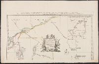
- Creator:
- Bonne, Rigobert, 1727-1794, cartographer.
- Published / Created:
- 1771
- Call Number:
- BrSides Folio 2017 8
- Image Count:
- 1
- Resource Type:
- Maps, Atlases & Globes
- Description:
- Left sheet: bottom right: 22. Right
- Subject (Geographic):
- Asiatic Russia--Maps--Early works to
- Found in:
- Beinecke Rare Book and Manuscript Library > Partie orientale de l'empire de Russie : extrait de l'Atlas Russien et d'autres cartes / projetée et assujetie aux observations astronomiques posterieures, par Mr. Bonne m.tre de mathémat. ; Arrivet inv. & sculp.
- Creator:
- Bacstrom, Sigismund
- Published / Created:
- 1792-1800, bulk 1792-1794.
- Call Number:
- WA MSS S-2405 (Oversize)
- Image Count:
- 130
- Abstract:
- Fitzhugh Sound. There are two maps of Queen
- Found in:
- Beinecke Rare Book and Manuscript Library > Drawings and sketches made during a voyage around the world, 1791-1795
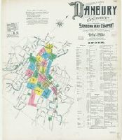
- Creator:
- Sanborn Map Company, issuing body
- Published / Created:
- 1904
- Call Number:
- 766 D19 1904
- Image Count:
- 23
- Resource Type:
- Maps, Atlases & Globes
- Abstract:
- Sanborn fire insurance maps are a rich
- Description:
- Partial cadastral map.
- Subject (Geographic):
- Danbury (Conn.)--Maps
- Subject (Name):
- Library of Congress. Map Division Stamp
- Subject (Topic):
- --Danbury--Maps
- Found in:
- Beinecke Rare Book and Manuscript Library > Insurance maps of Danbury, Fairfield County, Connecticut.
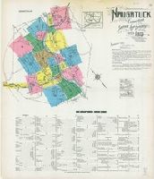
- Creator:
- Sanborn Map Company, issuing body
- Published / Created:
- 1923
- Call Number:
- 766 N22 1923
- Image Count:
- 23
- Resource Type:
- Maps, Atlases & Globes
- Abstract:
- Sanborn fire insurance maps are a rich
- Description:
- Partial cadastral map.
- Subject (Geographic):
- Naugatuck (Conn.)--Maps
- Subject (Topic):
- --Naugatuck--Maps
- Found in:
- Beinecke Rare Book and Manuscript Library > Naugatuck, New Haven County, Connecticut.
- Creator:
- Sanborn Map Company, issuing body
- Published / Created:
- 1931
- Call Number:
- 766 W73 1931
- Image Count:
- 23
- Resource Type:
- Maps, Atlases & Globes
- Abstract:
- Sanborn fire insurance maps are a rich
- Description:
- Partial cadastral map.
- Subject (Geographic):
- Winsted (Conn.)--Maps
- Subject (Topic):
- --Winsted--Maps
- Found in:
- Beinecke Rare Book and Manuscript Library > Winsted, Litchfield County, Connecticut.
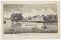
- Creator:
- Boydell, John, 1720-1804, printmaker
- Published / Created:
- 1753.
- Call Number:
- Topos M627 no. 16+
- Image Count:
- 1
- Resource Type:
- still image
- Description:
- No. 22, "Mr. and Mrs. George Morton
- Found in:
- Lewis Walpole Library > A view of Governour Pitts house at Twickenham Vüe de la maison du Governour Pitt a Twickenham / [graphic] =
- Creator:
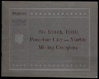
- Black Hills Porcelain Clay and Marble Mining Company
- Published / Created:
- 1900?]
- Call Number:
- Zc35 +900bL
- Image Count:
- 25
- Subject (Geographic):
- Black Hills (S.D. and Wyo.)--Maps
- Found in:
- Beinecke Rare Book and Manuscript Library > Prospectus : the Black Hills Porcelain Clay and Marble Mining Company (incorporated under laws of South Dakota) ...
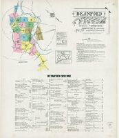
- Creator:
- Sanborn Map Company, issuing body
- Published / Created:
- 1924
- Call Number:
- 766 B72 1924
- Image Count:
- 24
- Resource Type:
- Maps, Atlases & Globes
- Abstract:
- Sanborn fire insurance maps are a rich
- Description:
- Partial cadastral map.
- Subject (Geographic):
- Branford (Conn.)--Maps
- Subject (Topic):
- --Branford--Maps
- Found in:
- Beinecke Rare Book and Manuscript Library > Branford : including Short Beach, Indian Neck, Pine Orchard, Stony Creek and Pine Orchard West, New Haven Co., Connecticut.
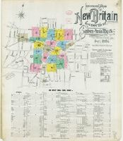
- Creator:
- Sanborn-Perris Map Co., issuing body
- Published / Created:
- 1895
- Call Number:
- 766 N42 1895
- Image Count:
- 24
- Resource Type:
- Maps, Atlases & Globes
- Abstract:
- Sanborn fire insurance maps are a rich
- Description:
- Partial cadastral map.
- Subject (Geographic):
- New Britain (Conn.)--Maps
- Subject (Topic):
- Britain--Maps
- Found in:
- Beinecke Rare Book and Manuscript Library > Insurance maps of New Britain, Hartford Co., Connecticut.
- Creator:
- Sanborn Map Company, issuing body
- Published / Created:
- 1911
- Call Number:
- 766 An81 1911
- Image Count:
- 25
- Resource Type:
- Maps, Atlases & Globes
- Abstract:
- Sanborn fire insurance maps are a rich
- Description:
- Partial cadastral map.
- Subject (Geographic):
- Ansonia (Conn.)--Maps
- Subject (Topic):
- --Ansonia--Maps
- Found in:
- Beinecke Rare Book and Manuscript Library > Insurance maps of Ansonia, Connecticut, New Haven County.
- Creator:
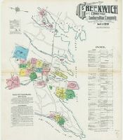
- Sanborn Map Company, issuing body
- Published / Created:
- 1912
- Call Number:
- 766 G852 1912
- Image Count:
- 25
- Resource Type:
- Maps, Atlases & Globes
- Abstract:
- Sanborn fire insurance maps are a rich
- Description:
- Partial cadastral map.
- Subject (Geographic):
- Greenwich (Conn. : Town)--Maps
- Subject (Topic):
- --Greenwich (Town)--Maps
- Found in:
- Beinecke Rare Book and Manuscript Library > Insurance Maps of Greenwich, Fairfield Co., Connecticut.