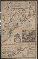
[South part of Carolina, and the east part of Florida], Draught of ye town and harbour of Charles-town, Map of the improved part of Carolina with the settlements, Map of the principal part of North America, and View of ye industry of ye beavers of Canada
Description:
Dedication: "To the honourable Walter Dowglass ... by ... Herman Moll ... ", Hand col. On sheet 104 x 64 cm. Recto: Stamped "Yale Horace Brown 1900S". Verso: Numbered "VIIIth" in ink ms.; labeled "English Dom: in N., and Publication date from Tooley.
Publisher:
Sold by H. Moll and by I. King at ye globe and ye poultrey near Stocks Market,
Subject (Geographic):
France--Colonies--America--Maps--Early works to 1800, Great Britain--Colonies--America--Maps--Early works to 1800, North America--Maps--Ear, and United States--History--Colonial period, ca. 1600-1775--Maps--Early works to 1800
Subject (Name):
Dowglass, Walter, dedicatee, King, John, fl. 1710-1749, publisher, and Moll, Herman, d. 1732, publisher
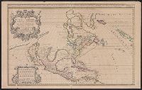
North America divided into its pri[n]cipall parts, viz. Arctick lands, New North Wales, N. South Wales, N. Brittain, Canada, N. Fpance [sic], N. Scotland, N. England, N. York, N. Jarsey, Mary-Land, Virginia, Carolina, Florida, Mexico or N. Spain, N. Mexic
Description:
"Sold by William Berry at the sign of the globe between Charing-Cross and White-Hall, 1680." and Dedication: To the most serene and most sacred majesty of Charles II, by the grace of God, king of Great Brittain, France, and Ireland, this map of North America
Publisher:
William Berry,
Subject (Geographic):
France--Colonies--America--Maps--Early works to 1800, Great Britain--Colonies--America--Maps--Early works to 1800, North America--Maps--Early works to 1800, and Spain--Colonies--America--Maps--Early works to 1800
"Published according to Act by Tho[ma]s Jefferys, geographer to His Royal Highness, the Prince of Wales, near Charing Cross.", Covers the east coast from Labrador to northern Florida, and the interior as far west as the Mississippi Valley., and Includes decorat
Publisher:
Thos. Jefferys,
Subject (Geographic):
France--Colonies--America--Maps--Early works to 1800, Great Britain--Colonies--America--Maps--Early works to 1800, and North America--Maps--Early works to 1800