Includes brief notes on the Irish history and political divisions., Inset: The sea coasts of Great Britain and Ireland. Scale approximately 1:4,500,000., Originally printed on 4 sheets., Relief shown pictorially., Robert Sayer traded alone & at this address 1751-1774 and 1783-1792 (cf. Maxted, p. l99)., Shows boundaries, rivers, lochs, roads with distances, woods and settlements., and Title cartouche depicts engraved stone, cow, and reclining figure holding a peat spade.
Publisher:
Printed for Robt. Sayer, opposite Fetter Lane, Fleet Street,
Inset: The sea coasts of Great Britain and Ireland. Scale approximately 1:4,500,000., Originally printed on 4 sheets., Relief shown pictorially., Robert Sayer traded alone & at this address 1751-1774 and 1783-1792 (cf. Maxted, p. l99)., Shows boundaries, rivers, lochs, roads with distances, woods and settlements., and Title cartouche depicts engraved stone, cow, and reclining figure holding a peat spade.
Publisher:
Printed for Robt. Sayer, opposite Fetter Lane, Fleet Street,
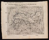
New and accurate map of Negroland and the adjacent countries
Description:
Includes decorative title cartouche with figures., Prime meridian: London, Relief shown pictorially., Shows boundaries, rivers, and principal settlements, with tents showing areas inhabited by nomads., and Watermark.
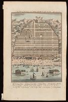
Bird's-eye view of Canton, now Guangzou, China; relief shown pictorially., From: Navigantium atque itinerantium bibliotheca ... / John Harris. -- London : T. Woodward, 1744-1748., In upper right-hand corner: Vol. 1. pa. 359., and Indexed for points on interest.
Publisher:
[T. Woodward],
Subject (Geographic):
Guangzhou (China)--Maps--Early works to 1800.
Subject (Name):
Harris, John, 1667?-1719. Navigantium atque itinerantium bibliotheca.
From his atlas Prospect of the World, pp. 9-10, sig. e, catch. in-., Includes text, inset of Greenland, and views of towns and ill. of figures in margins., Text of "The description of America" on verso., and Tooley identifies this as a 1676 issue, noting NY and Maryland mentioned for the first time in text about Virginia (section 14) on verso; and Hochelaga, Quebec, and Tadasac added to description of Canada.
Publisher:
are to be sold by Thomas Bassett in Fleet Street and by Richard Chiswell in St. Pauls Churchyard,
Subject (Geographic):
America--Maps--Early works to 1800.
Subject (Name):
Bassett, Thomas, bookseller., Chiswell, Richard., Goos, Abraham, engraver., and Speed, John, 1552?-1629. Prospect of the most famous parts of the world.
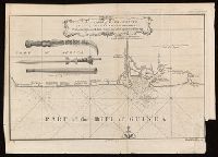
Coordinates not present on map and are approximated., From A new general collection of voyages and travels (London, 1745-47)., Includes illustrations of "weapons used by the Hakbous blacks.", Lower left: "No. 87.", Lower right: "Plate X, Vol. III, p. 105.", and Stamps: Glasgow Public Libraries.
Publisher:
[publisher not identified],
Subject (Geographic):
Cross River State (Nigeria)--Maps--Early works to 1800.
Subject (Name):
Child, G., engraver. and Glasgow (Scotland). Public Libraries Stamp.
Subject (Topic):
Coasts--Nigeria--Calabar Province--Maps--Early works to 1800.
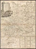
Concentric rings at one mile intervals from Huntingdon., Dedicated to the Robert Montagu, Duke of Manchester., Imperfect: edges trimmed, with loss of imprint information. Dissected and mounted on linen. In cover with label "17 Huntingdonshire.", Notes about the county; includes "Index Villaris.", Prime meridian: London., Relief shown by hachures., and Shows boundaries, roads, woods, parks and settlements.
Publisher:
[Emanuel Bowen?],
Subject (Geographic):
Huntingdonshire (England)--Early works to 1800--Maps.
Subject (Name):
Bowles, John, 1701-1779, publisher. and Hinton, John, -1781, bookseller.
"European Magazine" in upper right., Coordinates not present on map and are approximated., Imperfect: left portion of map and upper right portion of map wanting, with some loss of text., Relief shown pictorially., and Watermark.
Publisher:
Published April 1, 1782, by I. Fielding, Pater noster Row, J. Sewell, Cornhill, and J. Debrett, Piccadilly,
I haue heere added for the readers profit and delight this map of Iapan, published by I. Hondivs, I have heere added for the readers profit and delight this map of Iapan, published by I. Hondius, and Japan I.
Description:
Relief shown pictorially., Removed from Samuel Purchas's Purchas his Pilgrimage (1625)., and Text in English on verso with signature 3M3 at foot of map.
Publisher:
[Printed by William Stansby for Henrie Fetherstone],
Subject (Geographic):
Japan--Maps--Early works to 1800.
Subject (Name):
Featherstone, Henry, -1647, bookseller., Purchas, Samuel, 1577?-1626. Purchas his Pilgrimage. 1625., and Stansby, William, active 1597-1638, printer.