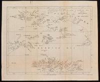
Carte topographique des villes de Londres, Westminster, et bourg de Southwark et de leurs environs., Exact survey of the cities of London and Westminster, the borough of Southwark and the country near ten miles round, and Urbium maxime insignium Londini et Westmonasterii nec non municipii Sudovercencis, regionumque ad decem quasi milliaria circumjacentium.
Description:
"Publish'd 29th of April ... ", No. 3 of 7 maps bound together in a vol. with hand-lettered dust jacket with ms. title, "Rocque's map of London, 1746,"and autograph of Ralph Hodgson., and Relief shown by shading.
Publisher:
John Rocque,
Subject (Geographic):
London (England)--Maps--Early works to 1800.
Subject (Name):
Hodgson, Ralph,--1871-1962--Autograph., Parr, Richard, fl. 1723-1751., and Pratt, W.
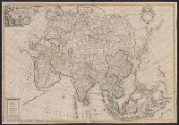
"Drawn & Engrav'd by Iohn Senex.", Appears in Senex's A new general atlas ... London: Printed for Daniel Browne ... [etc.], 1721., Decorative title cartouche depicting classical figures, engraved by H. Hulsbergh., Dedicated to Sir George Markham, Baronet., Imperfect: mutilated, with no loss of text. Ms. no. on verso: 4. Backed with paper. Sheet measures 69 x 99 cm. Cross Collection no. 98., and Map of Asia showing wind direction with relief shown pictorially.
Publisher:
At the Globe against St. Dunstan's Church, Fleet Street in London,
Subject (Geographic):
Asia--Maps--Early works to 1800
Subject (Name):
Hulsberg, Henry, d. 1729, engraver and Senex, John, d. 1740. New general atlas
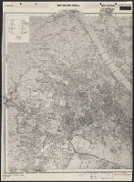
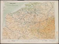
East sheet wanting., Great Britain. War Office. General Staff. Geographical Section. G.S.G.S. no. 4483., In English., and One map of two sheets taped: sheet 1: Austria, Wien (Vienna), west sheet; sheet 2: Austria: Wien (Vienna), east sheet. With "Inset of the to
Publisher:
G.S.G.S,
Subject (Geographic):
Vienna (Austria)--Maps
Subject (Topic):
Cities and towns, Land use, Roads--Maps, and Transportation
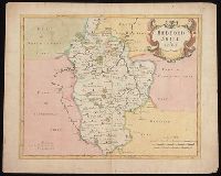
First state, produced prior to changes before 1722., From: Camden's Britannia, newly translated into English ... [London] : Printed by F. Collins, for A. Swalle ... and A. & J. Churchil ..., 1695., London meridian., Relief shown pictorially., and Shows boundaries, rivers, roads, woods, parks and settlements.
Publisher:
Sold by Abel Swale, Awnsham & Iohn Churchil,
Subject (Geographic):
Bedfordshire (England)--Maps--Early works to 1800.
Subject (Name):
Camden, William, 1551-1623. Britannia. English., Churchill, Awnsham, -1728, Churchill, John, active 1690-1714, and Swall, Abel
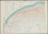
Great Britain. Army. Royal Engineers. Field Survey Coy., 512th
Published / Created:
1942
Call Number:
691 B43 1942
Container / Volume:
BRBL_00352
Image Count:
1
Resource Type:
Maps, Atlases & Globes
Alternative Title:
1:250,000 EGYPT AND CYRENAICA ; Sheet 1 Bengasi, 1:250,000 EGYPT AND CYRENAICA ; Sheet 1 Bengasi., and Sheet 1
Description:
"M.D.R. 1006/1646"., "Not to be published" printed along header., and Includes glossary, list of abbreviations, reliability diagram, and list of conventional signs.