Search
You Searched For
Search Results
- Published / Created:
- December 1st, 1757.
- Call Number:
- 5 1757
- Container / Volume:
- BRBL_00271
- Image Count:
- 5
- Resource Type:
- Maps, Atlases & Globes
- Found in:
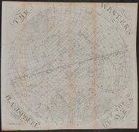
- Beinecke Rare Book and Manuscript Library > [Hemispherical maps and astronomical charts.]
- Creator:
- Des Barres, Joseph F. W. (Joseph Frederick Wallet), 1722-1824
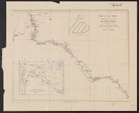
- Published / Created:
- Augt. 1st, 1781.
- Call Number:
- 734 S46 1781
- Container / Volume:
- BRBL_00380
- Image Count:
- 1
- Resource Type:
- Maps, Atlases & Globes
- Found in:
- Beinecke Rare Book and Manuscript Library > [Bay of Seven Islands, Québec].
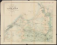
- Published / Created:
- 1781
- Call Number:
- 764cea C17 1781
- Container / Volume:
- BRBL_00461
- Image Count:
- 1
- Resource Type:
- Maps, Atlases & Globes
- Found in:
- Beinecke Rare Book and Manuscript Library > [A chart of the harbours of Hampton, Newbury, Ipswick, Jebeka, Squam, Cape Ann, Manchester, Beverly, Salem, Marblehead &c. Surveyed by Samuel Holland.
- Creator:
- Speed, John, 1552?-1629
- Published / Created:
- [1616]
- Call Number:
- 3223 1616
- Container / Volume:
- BRBL_00076
- Image Count:
- 2
- Resource Type:
- Maps, Atlases & Globes
- Found in:
- Beinecke Rare Book and Manuscript Library > Wilshire [cartographic material].
- Creator:
- Great Britain. War Office. General Staff. Geographical Section
- Published / Created:
- 1915
- Call Number:
- 11hc 1915E
- Image Count:
- 1
- Resource Type:
- Maps, Atlases & Globes
- Found in:
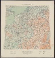
- Beinecke Rare Book and Manuscript Library > Western theatre of war.
- Creator:
- Anglo-German Boundary Commission
- Published / Created:
- 1907
- Call Number:
- 633 1907
- Container / Volume:
- BRBL_00336
- Image Count:
- 1
- Resource Type:
- Maps, Atlases & Globes
- Found in:
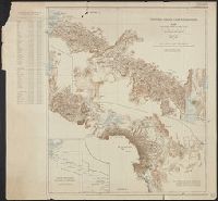
- Beinecke Rare Book and Manuscript Library > Victoria Nyanza to Mt. Kilimanjaro. Map of the country north and south of the Anglo German boundary reduced from the surveys of the British and German sections of the Commissions during the years 1904-1906.
- Creator:
- Clarke, W. B
- Published / Created:
- [1849?]
- Call Number:
- 40 V55 1849
- Image Count:
- 1
- Resource Type:
- Maps, Atlases & Globes
- Found in:
- Beinecke Rare Book and Manuscript Library > Venice = Venèzia = Venèdig / drawn by W.B. Clarke ; engraved by B.R. Davies.
- Published / Created:
- [1843?]
- Call Number:
- 7391 1843
- Container / Volume:
- BRBL_00394
- Image Count:
- 1
- Resource Type:
- Maps, Atlases & Globes
- Found in:
- Beinecke Rare Book and Manuscript Library > Vancouver's Island.
- Creator:
- Great Britain. War Office. General Staff. Geographical Section
- Published / Created:
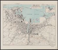
- 1943
- Call Number:
- 38 C42 1943
- Container / Volume:
- BRBL_00156
- Image Count:
- 1
- Resource Type:
- Maps, Atlases & Globes
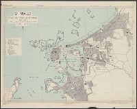
- Found in:
- Beinecke Rare Book and Manuscript Library > Town plan of Cherbourg [cartographic material] : France / drawn and photolithographed by War Office, 1943.
- Creator:
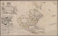
- Moll, Herman, d. 1732
- Published / Created:
- [1720]
- Call Number:
- 71 1720D
- Container / Volume:
- BRBL_00361
- Image Count:
- 1
- Resource Type:
- Maps, Atlases & Globes
- Found in:
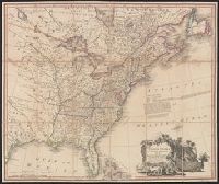
- Beinecke Rare Book and Manuscript Library > To the right honourable John Lord Sommers, Baron of Evesham in ye county of Worcester, president of Her Majesty's most honourable Privy Council &c., this map of North America, according to ye newest and most exact observations is most humbly dedicated by
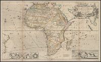
- Creator:
- Moll, Herman, -1732
- Published / Created:
- [1710]
- Call Number:
- 60 1708
- Container / Volume:
- BRBL_00322
- Image Count:
- 1
- Resource Type:
- Maps, Atlases & Globes
- Found in:
- Beinecke Rare Book and Manuscript Library > To the right honourable Charles, Earl of Peterborow and Monmouth, &c this map of Africa ... is most humbly dedicated / by your Lordship's humble servant H: Moll geographer.
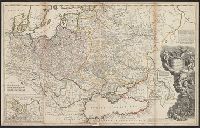
- Creator:
- Bowles, Thomas, -1767
Midwinter, Daniel, active 1698-1725
Moll, Herman, -1732
Overton, Philip, -1751
- Published / Created:
- [1708?]
- Call Number:
- 352 1708
- Container / Volume:
- BRBL_00104
- Image Count:
- 1
- Resource Type:
- Maps, Atlases & Globes
- Found in:
- Beinecke Rare Book and Manuscript Library > To his most serene and august majesty, Peter Alexovitz, absolute lord of Russia &c., this map of Moscovy, Poland, Little Tartary, and ye Black Sea &c. is most humbly dedicated by H. Moll, geographer.
- Published / Created:
- 1776
- Call Number:
- 771 N49 1776
- Container / Volume:
- BRBL_00484
- Image Count:
- 1
- Resource Type:
- Maps, Atlases & Globes
- Found in:
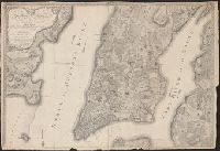
- Beinecke Rare Book and Manuscript Library > This plan of the city of New York and its environs ... B. Ratzer ... Thos. Kitchin sculp.
- Published / Created:
- [1720?]
- Call Number:
- 3615 1720
- Image Count:
- 1
- Resource Type:
- Maps, Atlases & Globes
- Found in:
- Beinecke Rare Book and Manuscript Library > The seat of war on the Rhine ... from Strasbourg to Bonn with the adjacent countries. By Mons. G. de L'Isle Geog.
- Published / Created:
- [1720?]
- Call Number:
- 3615 1720A
- Image Count:
- 1
- Resource Type:
- Maps, Atlases & Globes
- Found in:
- Beinecke Rare Book and Manuscript Library > The seat of war on the Rhine ... from Basil to Bonn with the adjacent countries. By Mons. W. de L'Isle Geog.
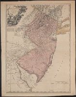
- Creator:
- Faden, William, 1749-1836
- Published / Created:
- 1778
- Call Number:
- 773 1778B
- Container / Volume:
- BRBL_00495
- Image Count:
- 1
- Resource Type:
- Maps, Atlases & Globes
- Found in:
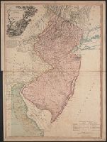
- Beinecke Rare Book and Manuscript Library > The province of New Jersey divided into east and west, commonly called the Jerseys / engraved ... by Wm. Faden.
- Published / Created:
- 1777
- Call Number:
- 773 1777
- Container / Volume:
- BRBL_00495
- Image Count:
- 1
- Resource Type:
- Maps, Atlases & Globes
- Found in:
- Beinecke Rare Book and Manuscript Library > The province of New Jersey divided into east and west, commonly called the Jerseys / engraved ... by Wm. Faden.
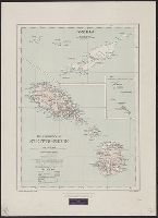
- Creator:
- Burdon, John Alder, Sir 1866-1933
- Published / Created:
- 1920
- Call Number:
- 861 1920
- Container / Volume:
- BRBL_00643
- Image Count:
- 1
- Resource Type:
- Maps, Atlases & Globes
- Found in:
- Beinecke Rare Book and Manuscript Library > The presidency of St. Kitts-Nevis [map] / ... compiled and brought up to date from existing surveys by J.A. Burdon.
- Published / Created:
- [1752]
- Call Number:
- BrSides 2019 82
- Image Count:
- 1
- Resource Type:
- Maps, Atlases & Globes
- Found in:
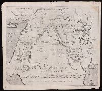
- Beinecke Rare Book and Manuscript Library > The place of Paradise, the habitation of Adam and Seth, and the land of Nod.
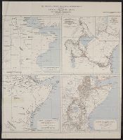
- Creator:
- Garstin, William, Sir, 1849-1925
- Published / Created:
- 1909
- Call Number:
- 60bh 1909
- Container / Volume:
- BRBL_00329
- Image Count:
- 1
- Resource Type:
- Maps, Atlases & Globes
- Found in:
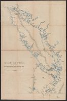
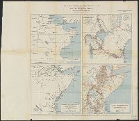
- Beinecke Rare Book and Manuscript Library > The jubilee of Speke's discovery of Victoria Nyanza : maps of Eastern Equatorial Africa showing the progress of exploration / to illustrate a paper by William E. Garstin.
- Creator:
- Garstin, William, Sir, 1849-1925
- Published / Created:
- 1909
- Call Number:
- 63bh 1909
- Container / Volume:
- BRBL_00335
- Image Count:
- 1
- Resource Type:
- Maps, Atlases & Globes
- Found in:
- Beinecke Rare Book and Manuscript Library > The jubilee of Speke's discovery of Victoria Nyanza : maps of Eastern Equatorial Africa showing the progress of exploration / to illustrate a paper by William E. Garstin.
- Creator:
- Moll, Herman, -1732
- Published / Created:
- [1736]
- Call Number:
- 867 1729
- Container / Volume:
- BRBL_00696
- Image Count:
- 1
- Resource Type:
- Maps, Atlases & Globes
- Found in:
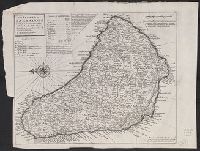
- Beinecke Rare Book and Manuscript Library > The island of Barbadoes [cartographic material] : divided into its parishes, with the roads, paths, &c. according to an actual and accurate survey / by H. Moll, geographer.
- Creator:
- Hole, William, -1624
- Published / Created:
- [1614]
- Call Number:
- BrSides 2019 83
- Image Count:
- 1
- Resource Type:
- Maps, Atlases & Globes
- Found in:
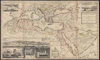
- Beinecke Rare Book and Manuscript Library > The great desert of Arabia.
- Published / Created:
- 1769
- Call Number:
- 3218 1769
- Container / Volume:
- BRBL_00058
- Image Count:
- 4
- Resource Type:
- Maps, Atlases & Globes
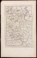
- Found in:
- Beinecke Rare Book and Manuscript Library > The county of Oxford Surveyed ... and engraved by Thomas Jefferys ... 1767.
- Published / Created:
- 1809
- Call Number:
- 755 1809
- Container / Volume:
- BRBL_00438
- Image Count:
- 1
- Resource Type:
- Maps, Atlases & Globes
- Found in:
- Beinecke Rare Book and Manuscript Library > The United States of North America : with the British territories and those of Spain.
- Published / Created:
- [1708?]
- Call Number:
- 501 1708A
- Container / Volume:
- BRBL_00275
- Image Count:
- 1
- Resource Type:
- Maps, Atlases & Globes
- Found in:
- Beinecke Rare Book and Manuscript Library > The Turkish Empire in Europe, Asia, and Africa ... H. Moll, Geographer.
- Published / Created:
- 1737
- Call Number:
- 32 1737
- Container / Volume:
- BRBL_00043
- Image Count:
- 1
- Resource Type:
- Maps, Atlases & Globes
- Found in:
- Beinecke Rare Book and Manuscript Library > The Travellers Guide through England and Wales ...
- Published / Created:
- 1707
- Call Number:
- 388hc 1707
- Image Count:
- 1
- Resource Type:
- Maps, Atlases & Globes
- Found in:
- Beinecke Rare Book and Manuscript Library > The Theater of the Warr in the Sevennes ... Mr. de Basville intendant of Languedoc ...
- Published / Created:
- 1792
- Call Number:
- 59 1792
- Container / Volume:
- BRBL_00316
- Image Count:
- 1
- Resource Type:
- Maps, Atlases & Globes
- Found in:
- Beinecke Rare Book and Manuscript Library > The Marches of the British Armies, ... during the Campaigns of 1790, and 1791 ...
- Published / Created:
- 1787
- Call Number:
- 39 1787
- Container / Volume:
- BRBL_00185
- Image Count:
- 1
- Resource Type:
- Maps, Atlases & Globes
- Found in:
- Beinecke Rare Book and Manuscript Library > The Kingdoms of Spain and Portugal ...
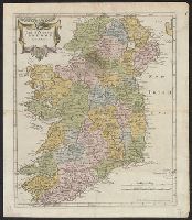
- Creator:
- A. and J. Churchill (Booksellers : London, England)
Morden, Robert, d. 1703
Swall, Abel
- Published / Created:
- [1680?]
- Call Number:
- 327 1680
- Container / Volume:
- BRBL_00072
- Image Count:
- 1
- Resource Type:
- Maps, Atlases & Globes
- Found in:
- Beinecke Rare Book and Manuscript Library > The Kingdom of Ireland / by Robt. Morden.
- Published / Created:
- 1910
- Call Number:
- 533ex 1910
- Container / Volume:
- BRBL_00288
- Image Count:
- 1
- Resource Type:
- Maps, Atlases & Globes
- Found in:
- Beinecke Rare Book and Manuscript Library > The Euphrates from Jerablus to Hit [cartographic material] : showing the route of Miss Gertrude Lowthian Bell along the eastern bank.
- Published / Created:
- 1790
- Call Number:
- 33 1790
- Container / Volume:
- BRBL_00077
- Image Count:
- 1
- Resource Type:
- Maps, Atlases & Globes
- Found in:
- Beinecke Rare Book and Manuscript Library > The Catholic Netherlands with the seven united provinces / engraved by S.J. Neele.
- Published / Created:
- [1756?]
- Call Number:
- 755 1756C
- Container / Volume:
- BRBL_00428
- Image Count:
- 1
- Resource Type:
- Maps, Atlases & Globes
- Found in:
- Beinecke Rare Book and Manuscript Library > The British & French dominions in North America : particularly shewing the French encroachments through all the British plantations from Nova Scotia down to the Gulf of Mexico.
- Published / Created:
- 1916
- Call Number:
- 44 1916
- Container / Volume:
- BRBL_00256
- Image Count:
- 1
- Resource Type:
- Maps, Atlases & Globes
- Found in:
- Beinecke Rare Book and Manuscript Library > The Balkan States and part of Austria-Hungary.
- Creator:
- Great Britain. War Office. General Staff. Geographical Section
- Published / Created:
- 1928
- Call Number:
- 615 1928
- Container / Volume:
- BRBL_00332
- Image Count:
- 1
- Resource Type:
- Maps, Atlases & Globes
- Found in:
- Beinecke Rare Book and Manuscript Library > The Anglo-Egyptian Sudan [cartographic material].
- Published / Created:
- [1914?]
- Call Number:
- 488 1914
- Container / Volume:
- BRBL_00266
- Image Count:
- 1
- Resource Type:
- Maps, Atlases & Globes
- Found in:
- Beinecke Rare Book and Manuscript Library > The Aegean Sea.
- Published / Created:
- [1914?]
- Call Number:
- 488 1914
- Container / Volume:
- BRBL_00266
- Image Count:
- 1
- Resource Type:
- Maps, Atlases & Globes
- Found in:
- Beinecke Rare Book and Manuscript Library > The Aegean Sea.
- Published / Created:
- 1823
- Call Number:
- 5856cea 1823
- Container / Volume:
- BRBL_00315
- Image Count:
- 1
- Resource Type:
- Maps, Atlases & Globes
- Found in:
- Beinecke Rare Book and Manuscript Library > Strait of Malacca. Sheet II. J. Walker sculpt.
- Published / Created:
- 1823
- Call Number:
- 5856cea 1823
- Container / Volume:
- BRBL_00315
- Image Count:
- 2
- Resource Type:
- Maps, Atlases & Globes
- Found in:
- Beinecke Rare Book and Manuscript Library > Strait of Malacca. Sheet II. J. Walker sculpt.
- Creator:
- Edward Stanford Ltd
- Published / Created:
- 1882
- Call Number:
- 611 1882
- Container / Volume:
- BRBL_00331
- Image Count:
- 2
- Resource Type:
- Maps, Atlases & Globes
- Found in:
- Beinecke Rare Book and Manuscript Library > Stanford's large scale map of the seat of war in Lower Egypt.
- Creator:
- Great Britain. Inter-service Topographical Dept
- Published / Created:
- 1943, 1944 printing.
- Call Number:
- 38 Sa233 1944
- Container / Volume:
- BRBL_00165
- Image Count:
- 1
- Resource Type:
- Maps, Atlases & Globes
- Found in:
- Beinecke Rare Book and Manuscript Library > St. Malo [cartographic material] : plan of port and town / compiled and drawn by Inter-Service Topographical Dept. ; produced under the Superintendence of Vice-Admiral John Edgell, hydrographer.
- Published / Created:
- 1908
- Call Number:
- 186 P93 1908
- Container / Volume:
- BRBL_00013
- Image Count:
- 1
- Resource Type:
- Maps, Atlases & Globes
- Found in:
- Beinecke Rare Book and Manuscript Library > Spitsbergen, preliminary map of Prince Charles foreland, from surveys by W. S. Bruce, 1906-7.
- Creator:
- Great Britain. War Office. General Staff. Geographical Section
- Published / Created:
- 1918
- Call Number:
- 186 1918
- Container / Volume:
- BRBL_00013
- Image Count:
- 1
- Resource Type:
- Maps, Atlases & Globes
- Found in:
- Beinecke Rare Book and Manuscript Library > Spitsbergen, GSGS 2877.
- Creator:
- Royal Geographical Society (Great Britain)
- Published / Created:
- 1913
- Call Number:
- 6551 1913
- Container / Volume:
- BRBL_00346
- Image Count:
- 1
- Resource Type:
- Maps, Atlases & Globes
- Found in:
- Beinecke Rare Book and Manuscript Library > Southern Nigeria : to illustrate the paper by A.E. Kitson.
- Published / Created:
- 1910
- Call Number:
- 649 1910
- Container / Volume:
- BRBL_00340
- Image Count:
- 1
- Resource Type:
- Maps, Atlases & Globes
- Found in:
- Beinecke Rare Book and Manuscript Library > South West Africa [cartographic material] : to illustrate a paper by Prof. H.H.W. Pearson.
- Published / Created:
- [1910]
- Call Number:
- 97 1910A
- Container / Volume:
- BRBL_00678
- Image Count:
- 1
- Resource Type:
- Maps, Atlases & Globes
- Found in:
- Beinecke Rare Book and Manuscript Library > South Peru and north Bolivia [cartographic material] : including the rubber yielding montaña.
- Published / Created:
- [1910]
- Call Number:
- 97 1910
- Container / Volume:
- BRBL_00678
- Image Count:
- 1
- Resource Type:
- Maps, Atlases & Globes
- Found in:
- Beinecke Rare Book and Manuscript Library > South Peru and north Bolivia [cartographic material] : including the rubber yielding montaña.