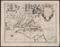
Author statement from McCorkle, p. 40., Includes ill. of animals and coat of arms., Relief shown pictorially., Verso: P. nos. "46", "45"; titles "The Description of New Neatherlands ... ", "The Description, and Verso: Stamped "Yale University Library".
Publisher:
Sold by Tho: Basset in Fleetstreet, and Richard Chiswell in St. Pauls Church Yard,
Subject (Geographic):
New England--Maps--Early works to 1800 and New York (State)--Maps--Early works to 1800
Subject (Name):
Bassett, Thomas, bookseller, Chiswell, Richard, Lamb, Francis, and Speed, John, 1552?-1629. Prospect of the most famous parts of the world
Appears in Speed's The theatre of the Empire of Great Britaine., English on recto, verso., Oriented west., Relief shown pictorially., Sheet measures 43.5 x 56 cm. Cross Collection no. 215., and Verso: Page nos. 43-44; titles "The description of Mary-land", "The description of Virginia"; signature Y.
Publisher:
Sold by Thomas Basset in Fleetstreet and Richard Chiswell in St. Pauls Church yard,
Subject (Geographic):
Maryland--History--Colonial period, ca. 1600-1775--Maps--Early works to 1800, Maryland--Maps--Early works to 1800, Virginia--History--Colonial period, ca. 1600-1775--Maps--Early works to 1800, and Virginia--Maps--Early works t
Subject (Name):
Bassett, Thomas, bookseller, Chiswell, Richard, Lamb, Francis, engraver, and Speed, John, 1552?-1629. Theatre of the Empire of Great Britaine
Appears in Speed's The theatre of the Empire of Great Britaine., English on recto, verso., Hand col. Sheet measures 41.7 x 54.4 cm., Oriented west., Relief shown pictorially., and Verso: Page nos. 43-44; titles "The description of Mary-land", "The descr
Publisher:
Sold by Thomas Basset in Fleetstreet and Richard Chiswell in St. Pauls Church yard,
Subject (Geographic):
Maryland--History--Colonial period, ca. 1600-1775--Maps--Early works to 1800, Maryland--Maps--Early works to 1800, Virginia--History--Colonial period, ca. 1600-1775--Maps--Early works t, and Virginia--Maps--Early works to 1800
Subject (Name):
Bassett, Thomas, bookseller, Chiswell, Richard, Lamb, Francis, engraver, and Speed, John, 1552?-1629. Theatre of the Empire of Great Britaine
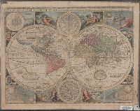
New and accurate map of the world and New and accvrat map of the world
Description:
Appeared in Speed's A prospect of the most famous parts of the world... London...1676., Imperfect: torn along fold, with some loss of text. Mounted on cardboard. Cross collection no. 18., Includes astrological charts, allegorical figures representing the elements, and portraits in medallions of explorers Sir Francis Drake, Ferdinand Magellan, Oliverus van der Noort and Thomas Candish., Relief shown pictorially., Scale measured at center of hemisphere., Shows California as an island., and This map is state 4, the last state published--Cf. Shirley R.W. Mapping of the world, 317.
Publisher:
Are to be sold by Tho. Bassett ... and Ric. Chiswell ...,
Subject (Name):
Bassett, Thomas, bookseller, bookseller, Chiswell, Richard, bookseller, and Speed, John, 1552?-1629. Prospect of the most famous parts of the world
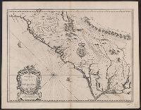
English on recto, verso., From John Speed's Theatre of the empire of Great Britain ... London : Printed for Thomas Basset ... and Richard Chiswel ..., 1676., Oriented west., Relief shown pictorially., Sheet measures 43.5 x 56. Cross Collection no. 219., and Verso: Page numbers "50", "49"; titles "The description of Carolina", "The description of Florida"; signature 2B.
Publisher:
Sold by Tho: Basset in Fleetstreet and Ric. Chiswell in St. Pauls Churchyard,
Subject (Geographic):
North Carolina--History--Colonial period, ca. 1600-1775--Maps--Early works to 1800, North Carolina--Maps--Early works to 1800, South Carol, and South Carolina--History--Colonial period, ca. 1600-1775--Maps--Early works to 1800
Subject (Name):
Bassett, Thomas, bookseller, Chiswell, Richard, Lamb, Francis, engraver, and Speed, John, 1552?-1629. Theatre of the Empire of Great Britaine
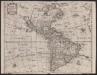
From Heylin's Cosmographie ... London : Printed for Henry Seile ..., 1652., Label on verso [with ms. nos.]: 559/122. Sheet measures 35.2 x 45.8 cm. Cross Collection no. 119., Relief shown pictorially., and Shows California as an island.
Publisher:
Impensis Henrici Seile,
Subject (Geographic):
America--Maps--Early works to 1800
Subject (Name):
Heylyn, Peter, 1600-1662. Microcosmus and Trevethen, William, engraver
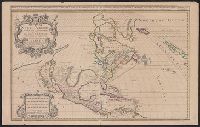
North America divided into its pri[n]cipall parts, viz. Arctick lands, New North Wales, N. South Wales, N. Brittain, Canada, N. Fpance [sic], N. Scotland, N. England, N. York, N. Jarsey, Mary-Land, Virginia, Carolina, Florida, Mexico or N. Spain, N. Mexic
Description:
"Sold by William Berry at the sign of the globe between Charing-Cross and White-Hall, 1680." and Dedication: To the most serene and most sacred majesty of Charles II, by the grace of God, king of Great Brittain, France, and Ireland, this map of North America
Publisher:
William Berry,
Subject (Geographic):
France--Colonies--America--Maps--Early works to 1800, Great Britain--Colonies--America--Maps--Early works to 1800, North America--Maps--Early works to 1800, and Spain--Colonies--America--Maps--Early works to 1800