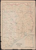
"55" and "56" in right margin., "Entered according to act of Congress in the year 187[?] by Asher & Adams in the office of the Librarian of Congress at Washington.", From the Streeter collection., Includes map of "Portion of Texas.", Prime meridians: Greenwich and Washington., and Shows counties and railroads.
Publisher:
Asher & Adams,
Subject (Geographic):
Texas--Administrative and political divisions--Maps and Texas--Maps
Subject (Name):
Streeter, Thomas W.--(Thomas Winthrop),--1883-1965--Ownership
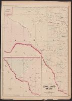
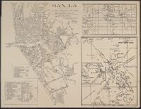
"57" and "58" in right margin., "Entered according to act of Congress in the year 187[?] by Asher & Adams in the office of the Librarian of Congress at Washington.", From the Streeter collection., Includes ancillary map of "Texas, western portion" showing El Paso and Presidio counties., Prime meridians: Greenwich and Washington., and Shows counties and "Texas Pacific R.R."
Publisher:
Asher & Adams,
Subject (Geographic):
Texas--Administrative and political divisions--Maps and Texas--Maps
Subject (Name):
Streeter, Thomas W.--(Thomas Winthrop),--1883-1965--Ownership
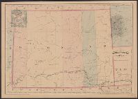
"Entered according to act of Congress in the year 1874 by Asher & Adams ....", In top margin: 119, 120., Prime meridians: Greenwich and Washington., and Relief shown by hachures.
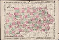
Iowa and Nebraska and Johnson's new illustrated family atlas of the world.
Description:
"Entered according to act of Congress in the year 1864 by A.J. Johnson in the clerks office of the district court of the United States for the southern district of New York." and Appears in 1866 edition of Johnson's new illustrated family atlas of the world,
"Presented to the subscribers of The Sun, January 4th, 1862, Moses S. Beach, proprietor.", Covers Delaware as far as Texas and Kansas, part of Florida as far north as Ohio, Indiana, and Illinois., and Decorative border with portraits: of Lincoln, Seward, Scott
Publisher:
The Sun, Moses S. Beach, Proprietor,
Subject (Geographic):
Confederate States of America--History--Maps and Middle West--History--Civil War, 1861-1865--Maps
Subject (Name):
Lincoln, Abraham,--1809-1865--Portraits, McClellan, George Brinton,--1826-1885--Portraits, Scott, Winfield,--1786-1866--Portraits, and Seward, William Henry,--1801-1872--Portraits
Coordinates not present on map and are approximated., Imperfect: torn along some folds, with no loss of text., Relief shown by hachures and pictorially., and Shows railway lines.
Publisher:
[Charles Scribner's Sons?],
Subject (Geographic):
Mexico City Region (Mexico)--Maps.
Subject (Name):
Janvier, Thomas A. (Thomas Allibone), 1849-1913. Mexican guide. and Pacheco, Carlos, 1839-1891.
"Prepared by M. Dripps for Valentine's Manuel [sic] of the Corporation of the city of New York.", 771 N49 1860C: Imperfect: mutilated, with some loss of text on sheet 2., and Depths shown on plate no. 2 by soundings.