Search
You Searched For
Search Results
- Creator:
- Rand McNally and Company
- Published / Created:
- [1882]
- Call Number:
- 75gme 1882B
- Container / Volume:
- BRBL_00413
- Image Count:
- 2
- Resource Type:
- Maps, Atlases & Globes
- Found in:
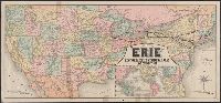
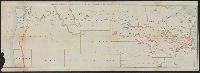
- Beinecke Rare Book and Manuscript Library > A correct map of the United States of America showing the Atchison, Topeka and Santa Fe R.R. and connections.
- Creator:
- Rand McNally and Company
- Published / Created:
- 1883
- Call Number:
- 75gme 1883
- Container / Volume:
- BRBL_00413
- Image Count:
- 2
- Resource Type:
- Maps, Atlases & Globes
- Found in:
- Beinecke Rare Book and Manuscript Library > Map of the "Erie" : New-York, Lake Erie and Western Rail Road and connections.
- Creator:
- Poole Brothers
- Published / Created:
- [1927], c1911.
- Call Number:
- 73gme 1927
- Container / Volume:
- BRBL_00376
- Image Count:
- 1
- Resource Type:
- Maps, Atlases & Globes
- Found in:
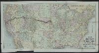
- Beinecke Rare Book and Manuscript Library > Map of the Canadian Pacific Railway, the Minneapolis, St. Paul & Sault Ste. Marie Railway, the Duluth, South Shore & Atlantic Railway, the Spokane International Railway and connections / Poole Bros, Chicago.
- Creator:
- Poole Brothers
- Published / Created:
- [1901?], c1893.
- Call Number:
- 73eu 1901
- Container / Volume:
- BRBL_00375B
- Image Count:
- 1
- Resource Type:
- Maps, Atlases & Globes
- Found in:
- Beinecke Rare Book and Manuscript Library > Map of the Canadian Pacific Railway, the Minneapolis, St. Paul and Sault Ste. Marie Railway, the Duluth, South Shore and Atlantic Railway and connections / Poole Bros, engravers.
- Creator:
- Rand McNally and Company
- Published / Created:
- [ca. 1874].
- Call Number:
- 75gme 1874
- Container / Volume:
- BRBL_00412
- Image Count:
- 1
- Resource Type:
- Maps, Atlases & Globes
- Found in:
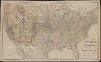
- Beinecke Rare Book and Manuscript Library > New map of the American overland route : showing its connections, and land grants of 30,000,000 acres / engraved and published by Rand McNally & Co.
- Creator:
- Rand McNally and Company
- Published / Created:
- [1882?]
- Call Number:
- 75gme 1882A
- Container / Volume:
- BRBL_00413
- Image Count:
- 1
- Resource Type:
- Maps, Atlases & Globes
- Found in:
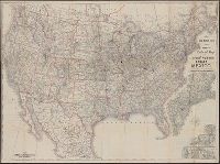
- Beinecke Rare Book and Manuscript Library > New map of the United States showing the complete railway system of the trans-Missouri country / prepared expressly for Crofutt's New overland tourist and Pacific coast guide, 1882, the Overland Publishing Company, Omaha, Neb., and Denver, Colo.
- Published / Created:
- c1883.
- Call Number:
- 75gme 1883C
- Container / Volume:
- BRBL_00413
- Image Count:
- 2
- Resource Type:
- Maps, Atlases & Globes
- Found in:
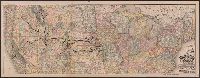
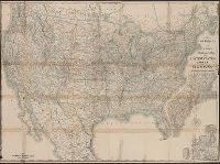
- Beinecke Rare Book and Manuscript Library > Official map of the Union Pacific Railway : through Kansas & Nebraska and from Colorado, Wyoming, Montana, Utah, Nevada, Idaho, Washington, Oregon & California.
- Creator:
- Rand McNally and Company
- Published / Created:
- [1912]
- Call Number:
- 80gme 1912B
- Container / Volume:
- BRBL_00540
- Image Count:
- 1
- Resource Type:
- Maps, Atlases & Globes
- Found in:
- Beinecke Rare Book and Manuscript Library > Outline map of the lines of the Chicago, Milwaukee & St. Paul Railway Company, Chicago, Milwaukee & Puget Sound Railway Company, and Tacoma Eastern Railway Company : June 30, 1912.
- Creator:
- Rand McNally and Company
- Published / Created:
- c1889.
- Call Number:
- 75gme 1889
- Container / Volume:
- BRBL_00414
- Image Count:
- 2
- Resource Type:
- Maps, Atlases & Globes
- Found in:
- Beinecke Rare Book and Manuscript Library > Rand McNally & Co.'s new official railroad map of the United States, Canada, and Mexico.
- Creator:
- Rand McNally and Company
- Published / Created:
- 1891, c1889.
- Call Number:
- 75gme 1891
- Container / Volume:
- BRBL_00414
- Image Count:
- 2
- Resource Type:
- Maps, Atlases & Globes
- Found in:
- Beinecke Rare Book and Manuscript Library > Rand McNally & Co.'s new official railroad map of the United States, Canada, and Mexico.