Skip to search
Skip to main content
Skip to first result
Search
You Searched For
Subject (Topic)
Nautical charts
Publication Place
England London
Search Results
Creator:
Published / Created:
1766. NB. With a book of directions.
Call Number:
2003 Folio 85
Image Count:
1
Description:
BEIN 2003 Folio 85: Without book of directions mentioned after publisher statement. No. 10 of 45 maps bound together with binder's spine title: Atlas of America; ms. table of contents. Bookplate: Robinson. Bookplate of Paul Mellon.
Publisher:
Published ... by James Cook, and sold by I. Mount and T. Page ... Tho's. Jeffrey ... and And'w. Dury ... London
Subject (Geographic):
Newfoundland and Labrador
Subject (Topic):
Coasts and Nautical charts
Found in:
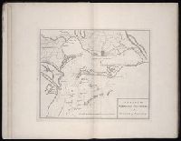
Beinecke Rare Book and Manuscript Library > A chart of part of the south coast of Newfoundland : including the islands St. Peters and Miquelon : from an actual survey taken by order of Commodore Pallisser, Governor of Newfoundland, Labrador, &c.
Creator:
Published / Created:
June 17th, 1780.
Call Number:
1982 Folio 10
Image Count:
1
Description:
BEIN 1982 Folio 10: Armorial bookplate: Charles Abbot. No. 8 of 42 maps bound together.
Publisher:
Engraved & published by W. Faden
Subject (Geographic):
North Sea, English Channel, France, England, and Biscay, Bay of (France and Spain)
Subject (Topic):
Nautical charts, Coasts, and Navigation
Found in:
Beinecke Rare Book and Manuscript Library > A chart of the British Channel and the Bay of Biscay with a part of the North Sea, and the entrance of St. George's Channel
Creator:
Published / Created:
1766.
Call Number:
2003 Folio 85
Image Count:
1
Description:
BEIN 2003 Folio 85: No. 9 of 45 maps bound together with binder's spine title: Atlas of America; ms. table of contents. Bookplate of Paul Mellon.
Subject (Geographic):
Newfoundland and Labrador, Belle Isle, Strait of, and Belle Isle, Strait of (N.L.)
Subject (Topic):
Nautical charts
Found in:
Beinecke Rare Book and Manuscript Library > A chart of the Straights of Bellisle with part of the coast of Newfoundland and Labradore from actual surveys. Taken by order of Commodore Pallisser, Governor of Newfoundland, Labrador, &ca.
Creator:
Published / Created:
June 28th, 1780.
Call Number:
1982 Folio 10
Image Count:
1
Description:
BEIN 1982 Folio 10: Armorial bookplate: Charles Abbot. No. 13 of 42 maps bound together.
Publisher:
Engraved & published by Wm. Faden
Subject (Geographic):
Spain, Portugal, Africa, North, and Mediterranean Sea
Subject (Topic):
Nautical charts and Coasts
Found in:
Beinecke Rare Book and Manuscript Library > A chart of the coasts of Spain and Portugal, with the Balearic Islands, and part of the coast of Barbary
Creator:
Published / Created:
Decr. 1766.
Call Number:
2003 Folio 85
Image Count:
1
Description:
BEIN 2003 Folio 85: No. 24 of 45 maps bound together with binder's spine title: Atlas of America; ms. table of contents. Bookplate: Robinson. Bookplate of Paul Mellon.
Publisher:
By the author
Subject (Geographic):
Port Royal (S.C.), South Carolina, and Port Royal
Subject (Topic):
Nautical charts
Found in:
Beinecke Rare Book and Manuscript Library > A draught of Port Royal Harbour in South Carolina : with the marks for going in : most humbly inscribed to the publick
Creator:
Published / Created:
Decem'r. 1766.
Call Number:
2003 Folio 85
Image Count:
1
Description:
BEIN 2003 Folio 85: No. 15 of 45 maps bound together with binder's spine title: Atlas of America; ms. table of contents. Bookplate: Robinson. Bookplate of Paul Mellon.
Publisher:
Published by the author according to Act of Parliament
Subject (Geographic):
Nova Scotia and Halifax (N.S.)
Subject (Topic):
Coasts and Nautical charts
Found in:
Beinecke Rare Book and Manuscript Library > A draught of the harbour of Halifax and the adjacent coast in Nova Scotia : surveyed by order of Commodore Spry
Creator:
Published / Created:
December 1766.
Call Number:
2003 Folio 85
Image Count:
1
Description:
BEIN 2003 Folio 85: No. 26 of 45 maps bound together with binder's spine title: Atlas of America; ms. table of contents. Bookplate: Robinson. Bookplate of Paul Mellon.
Publisher:
Published by the author according to Act of Parliament
Subject (Geographic):
Florida
Subject (Topic):
Coasts and Nautical charts
Found in:
Beinecke Rare Book and Manuscript Library > A draught of west Florida : with part of the river Mississippi
Creator:
Published / Created:
1777.
Call Number:
Drawer 777.07.22.01+
Image Count:
1
Description:
Relief shown by hachures. Depths shown by soundings and form lines.
Publisher:
Engraved & printed for Wm. Faden
Subject (Geographic):
Narragansett Bay (R.I.), Rhode Island, and Narragansett Bay
Subject (Topic):
Nautical charts and Defenses
Found in:
Lewis Walpole Library > A topographical chart of the bay of Narraganset in the province of New England : with all the isles contained therein, among which Rhode Island and Connonicut have been particularly surveyed, shewing the true position & bearings of the banks, shoals, rocks &c. as likewise the soundings: To which have been added the several works & batteries raised by the Americans. Taken by order of the principal farmers on Rhode Island
Creator:
Published / Created:
MDCCLXXI [1771]
Call Number:
1973 Folio 67
Image Count:
27
Description:
BEIN 1973 Folio 67: Armorial bookplate: John Bebb. Ms. corrections in text.
Publisher:
Printed for the author and sold by S. Hooper ...
Subject (Geographic):
West Indies, Caribbean Area, and Atlantic Coast (North America)
Subject (Topic):
Pilot guides, Harbors, and Nautical charts
Found in:
Beinecke Rare Book and Manuscript Library > The West-India pilot : containing piloting directions for Port Royal and Kingston harbours in Jamaica, in and out through the kays, &c. ... the true courses and distances through the windward passages ... courses, distances, and anchoring places from Jamaica to the Gulf of Florida ... : the whole illustrated with a number of maps and plans engraved by the best artists, describing the ports and bays above mentioned with the true soundings, laid down with the utmost exactness