Search
You Searched For
Search Results
- Published / Created:
- 1776
- Call Number:
- Cb23 27
- Collection Title:
- The American military pocket atlas : being an approved collection of correct maps, both general and
- Image Count:
- 1
- Alternative Title:
- , Newfoundland, Nova-Scotia, New-England, New-York
- Subject (Geographic):
- New England --Maps --Early works to
- Found in:
- Beinecke Rare Book and Manuscript Library > A General map of the northern British colonies in America. which comprehends the province of Quebec, the government of Newfoundland, Nova-Scotia, New-England and New-York. From the maps published by the Admiralty and Board of Trade regulated by the astronomic and trigonometric observations of M. von Holland and corrected from Governor Pownall's late map 1776.
- Creator:
- Vaughan, Robert, 17th cent., engraver
- Published / Created:
- 1624
- Call Number:
- Pequot +Sm4
- Collection Title:
- The generall historie of Virginia, New-England, and the Summer Isles : with the names of the
- Image Count:
- 1
- Subject (Topic):
- New England --History --Colonial period
- Found in:
- Beinecke Rare Book and Manuscript Library > A description of part of the adventures of Cap. Smith in Virginia
- Creator:
- Vaughan, Robert, 17th cent., engraver
- Published / Created:
- 1624
- Call Number:
- 2003 +39
- Collection Title:
- The generall historie of Virginia, New-England, and the Summer Iles ...
- Image Count:
- 1
- Subject (Topic):
- New England --History --Colonial period
- Found in:
- Beinecke Rare Book and Manuscript Library > A description of part of the adventures of Cap. Smith in Virginia
- Creator:
- Edwards, Jonathan, 1703-1758
- Published / Created:
- 1737
- Call Number:
- 1742 Yale Library 1.5.56
- Image Count:
- 3
- Resource Type:
- Books, Journals & Pamphlets
- Found in:
- Beinecke Rare Book and Manuscript Library > A faithful narrative of the surprizing work of God in the conversion of many hundred souls in Northampton, and the neighbouring towns and villages of [New]-Hampshire in New-England : in a letter to the Revd. Dr. Benjamin Colman of Boston
- Published / Created:
- 1776
- Call Number:
- Cb23 27
- Collection Title:
- The American military pocket atlas : being an approved collection of correct maps, both general and
- Image Count:
- 1
- Subject (Geographic):
- New England --Maps --Early works to
- Found in:
- Beinecke Rare Book and Manuscript Library > A general map of the middle British colonies in America. Containing Virginia, Maryland, the Delaware counties, Pennsylvania and New Jersey. With the addition of New York, and of the greatest part of New England, as also of the bordering parts of the province of Quebec, improved from several surveys made after the late war, and corrected from Governor Pownall's late map 1776.
- Creator:
- Jefferys, Thomas, d. 1771, creator
Mellon, Paul
- Published / Created:
- November 29th 1755
- Call Number:
- 2003 Folio 85
- Image Count:
- 1
- Subject (Geographic):
- New England -- Maps -- Early works to
- Found in:
- Beinecke Rare Book and Manuscript Library > A map of the most inhabited part of New England: containing the provinces of Massachusets Bay and New Hampshire, with the colonies of Conecticut and Rhode Island : divided into counties and townships : the whole composed from actual surveys and its situat
- Creator:
- Jefferys, Thomas, d. 1771, creator
- Published / Created:
- 1755
- Call Number:
- 2003 Folio 85
- Image Count:
- 1
- Description:
- Shows Maritime Provinces, New England
- Subject (Geographic):
- New England -- Maps -- Early works to
- Found in:
- Beinecke Rare Book and Manuscript Library > A new map of Nova Scotia, and Cape Britain: With the adjacent parts of New England and Canada, composed from a great number of actual surveys; and other materials regulated by many new astronomical observations of the longitude as well as latitude; with a
- Creator:
- Blaskowitz, Charles
- Published / Created:
- 1777.
- Call Number:
- Drawer 777.07.22.01+
- Image Count:
- 1
- Found in:
- Lewis Walpole Library > A topographical chart of the bay of Narraganset in the province of New England : with all the isles contained therein, among which Rhode Island and Connonicut have been particularly surveyed, shewing the true position & bearings of the banks, shoals, rocks &c. as likewise the soundings: To which have been added the several works & batteries raised by the Americans. Taken by order of the principal farmers on Rhode Island
- Creator:
- Defoe, Daniel, 1661?-1731.
Welwood, James, 1652-1727
- Published / Created:
- 1693
- Call Number:
- By50 W46
- Image Count:
- 26
- Publisher:
- at Boston in New-England by Benjamin
- Found in:
- Beinecke Rare Book and Manuscript Library > An answer to the late K. James’s last declaration, dated at St. Germains, April 17. s.n. 1693...
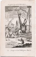
- Published / Created:
- [1769]
- Call Number:
- 769.09.00.01 Impression 1
- Image Count:
- 1
- Resource Type:
- still image
- Abstract:
- Temporal in New England”. A monkey on the quay
- Found in:
- Lewis Walpole Library > An attempt to land a bishop in America [graphic]