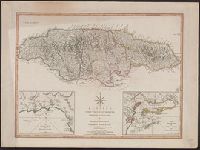
Harbour of Bluefields. and Harbours of Kingston and Port Royal.
Description:
Cross Collection no. 289., From Thomas Kitchin's New universal atlas. 6th ed. London : Robert Laurie and James Whitt, Prime meridians: Ferro and London., Printed no. on verso: 65., and Relief shown by hachures; soundings in fathoms.
Publisher:
Laurie & Whittle,
Subject (Geographic):
Jamaica--Maps--Early works to 1800, Kingston (Jamaica)--Maps--Early works to 1800, and Port Royal (Jamaica)--Maps--Early works to 1800
Subject (Name):
Kitchin, Thomas, 1718-1784. New universal atlas and Laurie & Whittle
Subject (Topic):
Harbors--Jamaica--Kingston--Maps--Early works to 1800 and Harbors--Jamaica--Port Royal--Maps--Early works to 1800
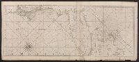
New and correct sea chart of the whole world shewing the variations of the compass as they were found in the year MDCC and Nova et accuratissima totius terrarum orbis tabula nautica, variationum magneticarum index juxta observationes anno. 1700
Description:
Text at bottom: "Sold by R. & W. Mount and T. Page in Postern Row, Tower Hill".
"B.F. 10" in upper right corner., Cross Collection no. 315., From Jefferys's American atlas. London : R. Sayer and J. Bennett, 1776., Prime meridians: Ferro and London., Relief shown pictorially; depths by soundings., and Stamped no. on verso: 26.
Publisher:
Printed for Robt. Sayer ...,
Subject (Geographic):
Central America--Maps--Early works to 1800, Honduras, Gulf of--Maps--Early works to 1800, and Mexico, Southeast--Maps--Early works to 1800
Subject (Name):
Jefferys, Thomas, d. 1771. American atlas and Sayer, Robert, 1725-1794
Subject (Topic):
Nautical charts--Honduras, Gulf of--Early works to 1800
Peninsula and Gulf of Florida or Channel of Bahama with the Bahama Islands
Description:
"DG.4.", From Jefferys's The American atlas ... London : Printed and sold by R. Sayer and J. Bennett, 1776., Hand colored., and Relief shown pictorially. Soundings shown in fathoms. "The soundings along the Florida coast, shoals, islands, and reefs are in feet."
Publisher:
Printed for Robt. Sayer, map and printseller ...,
Subject (Geographic):
Bahamas--Maps--Early works to 1800, Gulf Coast (Fla.)--Maps--Early works to 1800, and Gulf Coast (La.)--Maps--Early works to 1800
Subject (Name):
Jefferys, Thomas, d. 1771. American atlas and Sayer, Robert, 1725-1794
Peninsula and Gulf of Florida or Channel of Bahama with the Bahama Islands
Description:
"DG.4.", From Jefferys's The American atlas ... London : Printed and sold by R. Sayer and J. Bennett, 1776., Pictorial map, and Relief shown pictorially. Soundings shown in fathoms. "The soundings along the Florida coast, shoals, islands, and reefs are in feet."
Publisher:
Printed for Robt. Sayer, map and printseller ...,
Subject (Geographic):
Bahamas--Maps--Early works to 1800, Gulf Coast (Fla.)--Maps--Early works to 1800, and Gulf Coast (La.)--Maps--Early works to 1800
Subject (Name):
Jefferys, Thomas, d. 1771. American atlas and Sayer, Robert, 1725-1794
Peninsula and Gulf of Florida or Channel of Bahama with the Bahama Islands.
Description:
From Jefferys's The American atlas ... London : Printed and sold by R. Sayer and J. Bennett, 1776., Imperfect: detached along folds, with no loss of text. Sheets pasted together to form 1 sheet. Sheets measure 54 x 64 cm. and 54 x 66 cm., and Pictorial map.
Publisher:
Printed for Robt. Sayer, map and printseller ...,
Subject (Geographic):
Bahamas--Maps--Early works to 1800, Gulf Coast (Fla.)--Maps--Early works to 1800, and Gulf Coast (La.)--Maps--Early works to 1800
Subject (Name):
Jefferys, Thomas, d. 1771. American atlas and Sayer, Robert, 1725-1794
Atlas des Indes Occidentales. and The North American pilot.
Description:
From: The North American pilot. London, 1778-1779. Vol. 2, no. 13., Imperfect: chipped and torn, with no loss of text. Joined with Jeffrey's Island of Cuba with part of the Bahama banks & the Martyrs., Prime meridians: Ferro and London, Relief shown pictorially. Depths shown pictorially and by soundings., and Shows soundings, shoals and sailing channels.
Publisher:
Printed for Robt. Sayer, map & printseller, no. 53 Fleet Street, as the act directs,
Subject (Geographic):
Mexico, Gulf of--Maps--Early works to 1800, Yucatán Channel--Maps--Early works to 1800, and Yucatán Peninsula--Maps--Early works to 1800
Subject (Name):
Sayer, Robert, 1725-1794, publisher
Subject (Topic):
Nautical charts--Mexico, Gulf of--Early works to 1800 and Nautical charts--Yucatán Channel--Early works to 1800
Cuba with part of the Bahama banks & the Martyrs and The North American pilot.
Description:
From: The North American pilot. London, 1778-1779. Vol. 2, no. 13., Imperfect: chipped and torn, with no loss of text. Joined with Jeffrey's Coast of Yucatán from Campeche to Baha del Ascencion, with the west end of Cuba., Prime meridians: Ferro and London., Relief shown pictorially. Depths shown by soundings and shading., and Shows towns and roads in Cuba (except easternmost and westernmost parts) and part of Bahamas and Florida Keys.
Publisher:
Printed for Robt. Sayer,
Subject (Geographic):
Bahamas--Maps--Early works to 1800, Cuba--Maps--Early works to 1800, and Florida Keys (Fla.)--Maps--Early works to 1800