Copper engraving, colored to show coasts of Eng., Decorative cartouche containing royal arms; on respective countries - coats of arms; compass rose - n. to right; Neptune carrying union jack in upper left; 2 ships, a whale., and Removed fr. the Atlas Maritimus.
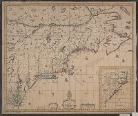
Map of New England, New Yorke, New Iersey, Mary-land & Virginia
Description:
"Separate publication ca. 1676" (McCorkle 38)., Includes hand colored illustration of American Indians., Relief shown pictorially., and Verso: Partially stamped "Yale University".
Publisher:
Sould by Robert Morden ... and by William Berry ... ,
Subject (Geographic):
Middle Atlantic States--Maps--Early works to 1800 and New England--Maps--Early works to 1800
Subject (Name):
Berry, William, fl. 1669-1708 and King, Gregory, 1648-1712, engraver
Accompanied by broadside text entitled: A description of New-England (4 p. ; 46 cm.)., Appears in author's Atlas maritimus, or, The sea-atlas, 1675., and Covers New England from the Penobscot River (Maine) region in the east to the Hudson River (New York) regio
Publisher:
And are to bee sold at his shop at the Hermitage in Wapping and by Iohn Hills in Exchange Alley in Cornhill,
Subject (Geographic):
New England--Maps--Early works to 1800
Subject (Name):
Hills, John, 17th cent and Seller, John, fl. 1658-1698. Atlas martitimus
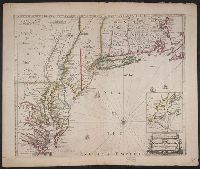
Map of Virginia, Maryland, New Jersey, New-York & New England and Mapp of New England
Description:
"Separate publication ca. 1673 ... Various dates have been assigned to the map, from 1673 to 1685" (McCorkle 33)., Inset: "A mapp of New England"., Relief shown p, and Reproduced in McCorkle, p. 33. Verso: Ink ms. annotations; numbered "57" in ink ms.
Publisher:
By John Thornton ... and by Robert Greene ... ,
Subject (Geographic):
Middle Atlantic States--Maps--Early works to 1800, New England--Maps--Early works to 1800, and New York (State)--Maps--Early works to 1800
"To the Rt. Honble Anthony Earle of Shaftesbury Baron Ashley of Wimbourne St. Giles and Lord Cooper of Pawlet....", Has watermark., Includes decorative cartouche and ill., and Relief shown pictorially.
Copper engraved sea chart, colored by hand to show coasts of English counties and French providinces, Flanders, Holland, etc ... Loxodromes, direction of compass, shoals, soundings, coastal towns., Decorative title, dedicatory, and scal, and Preliminary record.
"Imaginary plan of ancient Jerusalem within the outer wall oriented to the north"--Laor, E. Maps of the Holy Land., Has watermark., and Relief shown pictorially.
Publisher:
Printed for Ric. Chiswell,
Subject (Geographic):
Jerusalem--History--Maps and Jerusalem--Maps--Early works to 1800
Subject (Name):
Chiswell, Richard, Lightfoot, John, 1602-1675, and Lightfoot, John, 1602-1675. Works of the Reverend and learned John Lightfoot