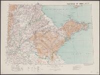
Great Britain. War Office. General Staff. Geographical Section
Published / Created:
1905
Call Number:
5616 1905
Container / Volume:
BRBL_00299
Image Count:
1
Resource Type:
Maps, Atlases & Globes
Alternative Title:
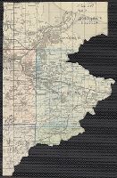
GSGS (Series) ; 1936., Province of Shandong, and T.S.G.S. ; no. 1936
Description:
Includes an English, Chinese explanation and a list of sources of information., Map of the Chinese province Shandong showing province and colonial boundaries, transportation, communications, ground and water features, missions and populated places., and Relief
Publisher:
Reproduced and printed for the Topographical Section, General Staff, at the Ordnance Survey Office,
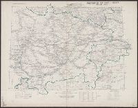
Great Britain. War Office. General Staff. Topographical Section
Published / Created:
1908]
Call Number:
5621 1908
Container / Volume:
BRBL_00299
Image Count:
1
Resource Type:
Maps, Atlases & Globes
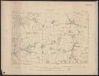
Description:
"Provisional issue without hills.", "T.S.G.S. No. 2048.", Eastern sheet -- Western sheet., Includes a Chinese, English explanation and a list of Sources of information., and Map of the Chinese province Ssŭ-ch'uan showing province boundaries, transportation, wate
Publisher:
Reproduced and printed for the Topographical Section, General Staff, at the Ordnance Survey Office,
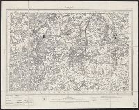
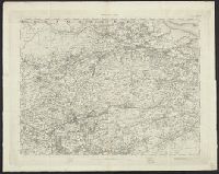
Geological Survey of Great Britain Great Britain. Ordnance Survey
Published / Created:
1864
Call Number:
32625 1865
Container / Volume:
BRBL_00071
Image Count:
5
Resource Type:
Maps, Atlases & Globes
Description:
Maps numbered in upper margin at right:, Relief shown by contours and spot heights., and Statement of attribution for geological information differs: Surveyed by Captain Pratt -- Contoured by Lt. Colonel Bayly -- Engraved under the direction of Colonel Cameron.
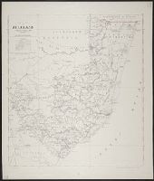
Great Britain. War Office. General Staff. Geographical Section
Published / Created:
1927
Call Number:
BrSides Folio 2018 131
Image Count:
1
Resource Type:
Maps, Atlases & Globes
Alternative Title:
GSGS (Series) ; 3857
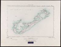
Description:
"250/27.", "Surveyed in 1898-99.", Bookseller's label at bottom of sheet: International Map Company, Inc. ... New York. N.Y., Relief shown by spot heights (in feet)., and Shows roads (2 categories) and parish boundaries.
Publisher:
Ordnance Survey Office,
Subject (Geographic):
Bermuda Islands--Maps.
Subject (Name):
Great Britain. Ordnance Survey and International Map Company