Skip to search
Skip to main content
Skip to first result
Search
You Searched For
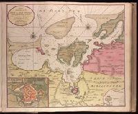
Publication Place
Tot Amsterdam
Search Results
Creator:
Published / Created:
[ca. 1734]
Call Number:
1973 Folio 18
Image Count:
1
Description:
BEIN 1973 Folio 18: Backed with paper. Ms. no. "10" in upper right-hand corner. Sheet measures 53.5 x 62.5 cm. No. 9 of 87 maps bound together.
Publisher:
By Gerard van Keulen
Subject (Geographic):
Wismar (Germany), Germany, and Wismar Bay
Subject (Topic):
Maps and Nautical charts
Found in:
Beinecke Rare Book and Manuscript Library > De Haven en Stad Wismar desselfs Districkt Belegering en Werken daer voor [cartographic material].
Creator:
Published / Created:
[ca. 1734?]
Call Number:
1973 Folio 18
Image Count:
1
Description:
BEIN 1973 Folio 18: Backed with paper. Ms. no. "58" in upper right-hand corner. Sheet measures 53.7 x 62.3 cm. No. 53 of 87 maps bound together.
Publisher:
By Gerard van Keulen
Subject (Geographic):
Sète (France), France, and Sète
Subject (Topic):
Maps and Nautical charts
Found in:
Beinecke Rare Book and Manuscript Library > De Haven van Cette in de Middelandse Zee in Langedoc [cartographic material].
Creator:
Published / Created:
[1734]
Call Number:
1973 Folio 18
Image Count:
1
Description:
BEIN 1973 Folio 18: Backed with paper. Ms. no. "13" in upper right-hand corner. Sheet measures 53.6 x 35.5 cm. No. 13 of 87 maps bound together.
Publisher:
By Gerard van Keulen ...
Subject (Geographic):
Rügen Island (Germany), Stralsund (Germany), and Baltic Sea
Subject (Topic):
Northern War, 1700-1721, Maps, and Nautical charts
Found in:
Beinecke Rare Book and Manuscript Library > De kust van Pomeren, hey eyland Rugen [cartographic material].
Creator:
Published / Created:
[1692?]
Call Number:
2008 +141
Image Count:
65
Abstract:
A series of sixty plates published in Amsterdam and with captions in Dutch and French, this work illustrates the Glorious Revolution in England, from the flight of James II through the coronation of William and Mary.
Alternative Title:
Engelands schouwtoneel and Theatre d’Angleterre
Publisher:
by Adr. Schoonebeek in de Kalverstraat
Subject (Geographic):
Great Britain --History --James II, 1685-1688 --Pictorial works, Great Britain --History --Revolution of 1688 --Pictorial works, and Great Britain --History --William and Mary, 1689-1702 --Pictorial works
Found in:
Beinecke Rare Book and Manuscript Library > Engelants schouwtoneel = Le theatre d’Angleterre
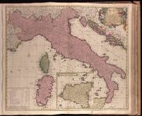
Creator:
Published / Created:
[169-?]
Call Number:
1973 Folio 18
Image Count:
1
Description:
BEIN 1973 Folio 18: Backed with paper. Ms. no. "65" in upper right corner. Sheet measures 53.7 x 62.5 cm. No. 60 of 87 maps bound together.
Publisher:
Gedrukt by C. Allard ...
Subject (Geographic):
Italy
Found in:
Beinecke Rare Book and Manuscript Library > Italia in suos quoscunq[ue] status divisa, iiq[ue] iterum in particulares ditiones distributi, huic accedunt insulae Sicilia, Sardinia, Corsica & c. quae suos ad principes nominatim referuntur / [cartographic material]
Creator:
Published / Created:
[173-?]
Call Number:
1973 Folio 18
Image Count:
2
Alternative Title:
Royaume de France divisé en toutes ses provinces
Description:
BEIN 1973 Folio 18: Imperfect: torn along fold, with no loss of text. Backed with paper. Ms. no. "50" in upper-right corner. No. 47 of 87 maps bound together.
Publisher:
By Gerard van Keulen ...
Subject (Geographic):
France
Found in:
Beinecke Rare Book and Manuscript Library > Le Royaume de France : distingué suivant l'estendue de toutes ses provinces et ses acquisitions, dans l'Espagne, dans l'Italie, dans l'Allemagne et dans les Pays Bas
Creator:
Published / Created:
[1716]
Call Number:
1973 Folio 18
Image Count:
1
Description:
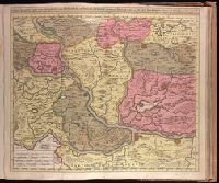
BEIN 1973 Folio 18: Backed with paper. Ms. no. "78" in upper right-hand corner. Sheet measures 53.6 x 62.8 cm. No. 72 of 87 maps bound together.
Publisher:
By Gerard van Keulen, met privel
Subject (Geographic):
Serbia
Subject (Topic):
Austro-Turkish War, 1716-1718 and Maps
Found in:
Beinecke Rare Book and Manuscript Library > Nieuwe accurate kaert van een gedeelte van Hongarie en Donau Stroom vertonende Belgrado en Peter Wardein, alwaer de Batalje is Voor gevallen tussen de Kyser en Groote Turk, den 5 Augustus 1716, als ook de Stad Temeswar nu door den Kyser ingenomen nevens de Daar omtrent geleegenen Provintien en Steeden / [cartographic material]
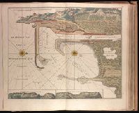
Creator:
Published / Created:
[ca. 1734]
Call Number:
1973 Folio 18
Image Count:
1
Alternative Title:
Haven en Stad Wismar
Description:
BEIN 1973 Folio 18: Backed with paper. Ms. no. "9" [partially trimmed] in upper right-hand corner. Sheet measures 53.5 x 62.5 cm. No. 8 of 87 maps bound together.
Publisher:
By Gerard van Keulen
Subject (Geographic):
Wismar (Germany), Germany, and Wismar Bay
Subject (Topic):
Maps and Nautical charts
Found in:
Beinecke Rare Book and Manuscript Library > Nieuwe afteekening van de Haven en Stad Wismar met desselfs inkoomende Zee Gaatten soo beoosten als bewesten Poel Eyland en beleegering van dito Stad. [cartographic material]
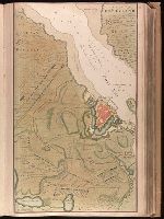
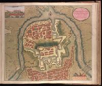
Creator:
Published / Created:
[1717]
Call Number:
1973 Folio 18
Image Count:
1
Description:
BEIN 1973 Folio 18: Backed with paper. Ms. no. "79" in upper right-hand corner. Sheet measures 53.6 x 62.5 cm. No. 73 of 87 maps bound together.
Publisher:
By Gerard van Keulen, aen de Nieuwen Brug
Subject (Geographic):
Belgrade (Serbia)
Subject (Topic):
Austro-Turkish War, 1716-1718
Found in:
Beinecke Rare Book and Manuscript Library > Nieuwe afteekening van de sterke stad Belgrado met desselfs Kasteel en alle de Buyten Werken in syn platte Grond ... berent den 24 Juny 1717 [cartographic material].
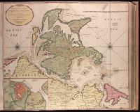
Creator:
Published / Created:
[1734]
Call Number:
1973 Folio 18
Image Count:
1
Description:
BEIN 1973 Folio 18: Backed with paper. Ms. no. "13" in upper right-hand corner. Sheet measures 53.6 x 62.8 cm. No. 12 of 87 maps bound together.
Publisher:
By Gerard van Keulen ...
Subject (Geographic):
Rügen Island (Germany), Stralsund (Germany), and Baltic Sea
Subject (Topic):
Maps and Nautical charts
Found in:
Beinecke Rare Book and Manuscript Library > Nieuwe afteekening van het eyland Rugen en de Straalsond als mede de stad Straalsond en t Nieuwe diep met alle desselfs gelegentheden int groot. [cartographic material]