Search
You Searched For
Search Results
- Creator:
- Great Britain. War Office. General Staff. Geographical Section
- Published / Created:
- 1943
- Call Number:
- 408 Sy76 1943
- Container / Volume:
- BRBL_00239
- Image Count:
- 1
- Resource Type:
- Maps, Atlases & Globes
- Found in:
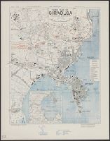
- Beinecke Rare Book and Manuscript Library > Town plan of Siracusa [cartographic material] / photolithographed by the Ordnance Survey, 1943.
- Creator:
- Great Britain. Army. Royal Engineers. Fd. Survey Coy., 512
- Published / Created:
- 1943
- Call Number:
- 40 T17 1943
- Image Count:
- 1
- Resource Type:
- Maps, Atlases & Globes
- Found in:
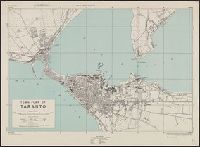
- Beinecke Rare Book and Manuscript Library > Town plan of Taranto [cartographic material] / reproduced by 512 Fd. Survey Coy., R.E., June, 1943, from W.O. pulls 1st edition, 1942, with revision from air photographs, dated 1943.
- Creator:
- Great Britain. War Office. General Staff. Geographical Section
- Published / Created:
- 1943
- Call Number:
- 40 T729 1943
- Image Count:
- 1
- Resource Type:
- Maps, Atlases & Globes
- Found in:
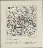
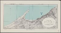
- Beinecke Rare Book and Manuscript Library > Town plan of Treviso [cartographic material].
- Creator:
- Great Britain. War Office. General Staff. Geographical Section
- Published / Created:
- 1943
- Call Number:
- 685 T83 1943
- Container / Volume:
- BRBL_00351
- Image Count:
- 1
- Resource Type:
- Maps, Atlases & Globes
- Found in:
- Beinecke Rare Book and Manuscript Library > Town plan of Tunis / drawn by War Office.
- Creator:
- Great Britain. War Office. General Staff. Geographical Section
- Published / Created:
- 1943
- Call Number:
- 40 Ud5 1943
- Image Count:
- 1
- Resource Type:
- Maps, Atlases & Globes
- Found in:
- Beinecke Rare Book and Manuscript Library > Town plan of Udine [cartographic material].
- Creator:
- Great Britain. Inter-service Topographical Dept
- Published / Created:
- 1943
- Call Number:
- 40 V652 1943
- Image Count:
- 1
- Resource Type:
- Maps, Atlases & Globes
- Found in:
- Beinecke Rare Book and Manuscript Library > Town plan of Vibo Valentia Marina [cartographic material] / compiled and drawn by Inter-Service Topographical Department ; produced under the Superintendence of Vice-Admiral John Edgell, hydrographer.
- Creator:
- Great Britain. War Office. General Staff. Geographical Section
- Published / Created:
- 1943
- Call Number:
- 40 V66 1943
- Image Count:
- 1
- Resource Type:
- Maps, Atlases & Globes
- Found in:
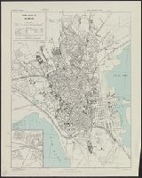
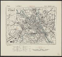
- Beinecke Rare Book and Manuscript Library > Town plan of Vicenza [cartographic material].
- Creator:
- Great Britain. War Office. General Staff. Geographical Section
- Published / Created:
- 1943
- Call Number:
- 408 V83 1943
- Container / Volume:
- BRBL_00239
- Image Count:
- 1
- Resource Type:
- Maps, Atlases & Globes
- Found in:
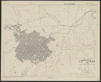
- Beinecke Rare Book and Manuscript Library > Town plan of Vittoria [cartographic material] / drawn and photolithographed by War Office, 1943.
- Creator:
- United States. Hydrographic Office
- Published / Created:
- Sep., 1914 [that is, 1916]
- Call Number:
- BrSides Elephant Folio 2018 22
- Image Count:
- 1
- Resource Type:
- Maps, Atlases & Globes
- Found in:
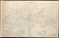
- Beinecke Rare Book and Manuscript Library > Tracks for full powered steam vessels with the shortest navigable distances in nautical miles from anchorage to anchorage, New York distances are measures to and from the Battery achorage.
- Creator:
- Great Britain. Army. Middle East Forces
- Published / Created:
- 1943
- Call Number:
- 69 T73 1943
- Container / Volume:
- BRBL_00352
- Image Count:
- 1
- Resource Type:
- Maps, Atlases & Globes
- Found in:
- Beinecke Rare Book and Manuscript Library > Tripoli : city plan / prepared under the direction of the Chief of Engineers, U.S. Army.