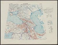
Great Britain. War Office. General Staff. Geographical Section United States. Army Map Service
Published / Created:
1942
Call Number:
354 1942
Container / Volume:
BRBL_00112
Image Count:
1
Resource Type:
Maps, Atlases & Globes
Alternative Title:
[G.S.G.S.] 4327 and GSGS (Series) ; 4327.
Description:
"Copied from a map produced by 512 (A. Fd. svy.) coy. R.E., January 1942 and collated by Mid-Asiatic bureau M.E.", In lower right corner of margin: Reprint November 1942., Relief shown by hachures and shading., and Two gauges of railroads, principal roads and tr
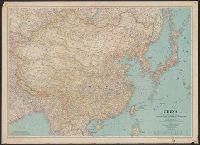
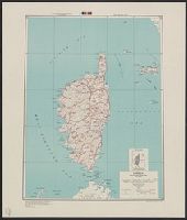
National Geographic Society (U.S.). Cartographic Section
Published / Created:
1945
Call Number:
56 1945
Container / Volume:
BRBL_00296
Image Count:
1
Resource Type:
Maps, Atlases & Globes
Description:
"June 1945.", Accompanied by: Index to Map of China / prepared in the Cartographic Department of the National Geographic Society for the National Geographic Society Magazine with 7,986 place names (35 p. ; 20 cm.)., and Relief shown by shading and spot heights.
Publisher:
Lithographed by A. Hoen and Co., and National Geographic Society ;
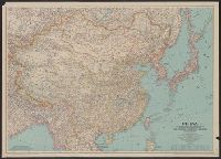
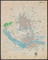
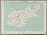
Fu-chou (Foochow) and Nan-t'ai, China, Fukien Province, Fu-chou and Nan-ta̓i, and L901
Description:
"Compiled in 1945 from China 1:50,000 Army Map Service 8833 II (Type C) 1945. Planimetric detail intensifie, Marginal maps: Coverage diagram -- Index to boundaries., Military grid., and Some streets and buildings are named; wooded and cultivated areas are shown.
Publisher:
U.S. Army Map Service,
Subject (Geographic):
Fuzhou (Fujian Sheng, China)--Maps and Nan-t'ai Shi (Fujian Sheng, China)--Maps
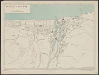
"3-43.", "Copied from French map, 1:50,000, Colmar F 37-18, revised to 1926.", "First edition 1943.", A few buildings are named., Military grid., Place names and buildings in French., and Relief show by spot heights.
France 1:5,800, Geographical Section, General Staff ; no. 4234, and GSGS (Series) ; 4234.
Description:
"1-44, 1944.", "First G.S.G.S. edition, 1943.", "Grid provisional, Nord de Guerre zone grid.", "War Office, 1943.", and Important streets and buildings are named.
Publisher:
Army Map Service, U.S. Army, and War Office ;
Subject (Geographic):
Deauville (France)--Maps and Trouville-sur-Mer (France)--Maps