Search
You Searched For
Search Results
- Creator:
- Ringgold, Cadwalader, 1802-1867
- Published / Created:
- [1851?]
- Call Number:
- 844cea Sa52 1850A
- Container / Volume:
- BRBL_00614
- Image Count:
- 1
- Resource Type:
- Maps, Atlases & Globes
- Found in:
- Beinecke Rare Book and Manuscript Library > Chart of the Farallones and entrance to the bay of San Francisco : California / by Cadwalader Ringgold, Commander, U.S. Navy ; assisted by Simon F. Blunt, Lieut., U.S. Navy, 1850.
- Creator:
- Ringgold, Cadwalader, 1802-1867
- Published / Created:
- [1851?]
- Call Number:
- 844cea Sa52 1850D
- Container / Volume:
- BRBL_00614
- Image Count:
- 1
- Resource Type:
- Maps, Atlases & Globes
- Found in:
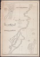
- Beinecke Rare Book and Manuscript Library > Chart of the Sacramento River from Suisun City to the American River : California / by Cadwalader Ringgold, Commander, U.S. Navy ; assisted by Edwin Cullberg, Lieut. of the Hydrotechnic Corps, Swedish Navy, and T.A. Emmet, civil engineer, 1850.
- Creator:
- Ringgold, Cadwalader, 1802-1867
- Published / Created:
- [1851?]
- Call Number:
- 844cea Sa52 1850D
- Container / Volume:
- BRBL_00614
- Image Count:
- 1
- Resource Type:
- Maps, Atlases & Globes
- Found in:
- Beinecke Rare Book and Manuscript Library > Chart of the Sacramento River from Suisun City to the American River : California / by Cadwalader Ringgold, Commander, U.S. Navy ; assisted by Edwin Cullberg, Lieut. of the Hydrotechnic Corps, Swedish Navy, and T.A. Emmet, civil engineer, 1850.
- Creator:
- Ringgold, Cadwalader, 1802-1867
- Published / Created:
- [1851?]
- Call Number:
- 844cea Sa52 1850B
- Container / Volume:
- BRBL_00614
- Image Count:
- 1
- Resource Type:
- Maps, Atlases & Globes
- Found in:
- Beinecke Rare Book and Manuscript Library > Chart of the bay of San Pablo, Straits of Carquines, and part of the bay of San Francisco : California / by Cadwalader Ringgold, Commander, U.S. Navy ; assisted by Simon F. Blunt, Lieut., U.S.N., 1850.
- Creator:
- National Geographic Society (U.S.). Cartographic Section
- Published / Created:
- 1945
- Call Number:
- 56 1945
- Container / Volume:
- BRBL_00296
- Image Count:
- 1
- Resource Type:
- Maps, Atlases & Globes
- Found in:
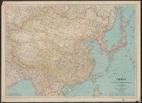
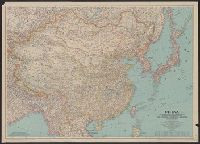
- Beinecke Rare Book and Manuscript Library > China [cartographic material] / compiled and drawn in the Cartographic Section of the National Geographic Society for the National Geographic Magazine ; James M. Darley, chief cartographer.
- Creator:
- National Geographic Society (U.S.). Cartographic Section
- Published / Created:
- 1945
- Call Number:
- 56 1945
- Container / Volume:
- BRBL_00296
- Image Count:
- 1
- Resource Type:
- Maps, Atlases & Globes
- Found in:
- Beinecke Rare Book and Manuscript Library > China [cartographic material] / compiled and drawn in the Cartographic Section of the National Geographic Society for the National Geographic Magazine ; James M. Darley, chief cartographer.
- Creator:
- United States. Army Map Service
- Published / Created:
- 1945
- Call Number:
- 56 F73 1945
- Container / Volume:
- BRBL_00296
- Image Count:
- 1
- Resource Type:
- Maps, Atlases & Globes
- Found in:
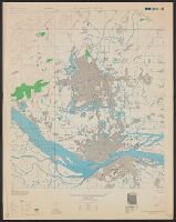
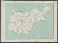
- Beinecke Rare Book and Manuscript Library > China city plans 1:12,500. Fu-chou and Nan-ta̓i / prepared under the direction of the Chief of Engineers by the Army Map Service (AM) ... 1945 [cartographic material].
- Creator:
- United States. Army Map Service
- Published / Created:
- 1942
- Call Number:
- 6547 C74 1945
- Container / Volume:
- BRBL_00344
- Image Count:
- 1
- Resource Type:
- Maps, Atlases & Globes
- Found in:
- Beinecke Rare Book and Manuscript Library > City plan of Conakry.