Skip to search
Skip to main content
Skip to first result
Search
You Searched For
Access
Public
Genre
Maps
Creator
Great Britain. War Office. General Staff. Geographical Section
Publication Place
Washington :
New Search
Search Results
Creator:
Published / Created:
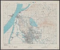
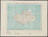
1945
Call Number:
56 N15 1945
Container / Volume:
BRBL_00297
Image Count:
1
Resource Type:
Maps, Atlases & Globes
Alternative Title:
[U.S. Army Map Service. A.M.S. ; L901], GSGS (Series) ; 3831., Its [G.S.G.S.] ; 3831, and Series (Standard map series designation system) ; L901.
Description:
"5-45.", "Contour interval 10 metres.", At head of title: China., Four classes of roads and paths are shown; some streets and buildings are named; areas of vegetation and cultivation are shown., and Military grid.
Publisher:
Army Map Service,
Subject (Geographic):
Nanjing (Jiangsu Sheng, China)--Maps
Subject (Name):
United States. Army Map Service
Found in:
Beinecke Rare Book and Manuscript Library > Nanking [cartographic material].
Creator:
Published / Created:
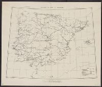
1943
Call Number:
39gme 1943
Container / Volume:
BRBL_00192
Image Count:
1
Resource Type:
Maps, Atlases & Globes
Alternative Title:
Geographical Section, General Staff ; no. 4170 and GSGS (Series) ; 4170.
Description:
In upper margin: C. B. 4096 D ... March 1941. and Railroads are classified as steam or electric, double or single track, and broad or other gauge.
Publisher:
Army Map Service, U. S. Army,
Subject (Topic):
Maps--Portugal--1943, Maps--Spain--1943, Railroads--Portugal--Maps, and Railroads--Spain--Maps
Found in:
Beinecke Rare Book and Manuscript Library > Railways in Spain and Portugal [cartographic material].
Creator:
Published / Created:
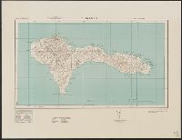
1943
Call Number:
213 Sa61 1943
Container / Volume:
BRBL_00015
Image Count:
1
Resource Type:
Maps, Atlases & Globes
Alternative Title:
G.S.,G.G., ; no. 4115 and GSGS (Series) ; 4115.
Description:
Elevations shown by form lines and spot heights., In upper margin: Cape Verde ids ..., and Military grid.
Publisher:
Army Map Service, U.S. Army,
Subject (Geographic):
São Nicolau Island (Cape Verde)--Maps, Topographic
Found in:
Beinecke Rare Book and Manuscript Library > S. Nicolau / drawn at War Office, 1940, from a Portuguese map of 1929.
Creator:
Published / Created:
1943
Call Number:
213 Sa611 1943
Image Count:
1
Resource Type:
Maps, Atlases & Globes
Alternative Title:
G.S.,G.S. 4116. and GSGS (Series) ; 4116.
Description:
In upper margin: Cape Verde Ids., Index map cataloged with G.S.G.S. 4111., Military grid., and Relief shown by form lines and contours.
Publisher:
Army Map Service,
Subject (Geographic):
São Tiago Island (Cape Verde)--Maps
Found in:
Beinecke Rare Book and Manuscript Library > S. Tiago / drawn at War Office, 1940, from a Portuguese map of 1932
Creator:
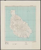
Published / Created:
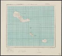
1943
Call Number:
213 Sa62 1943
Image Count:
1
Resource Type:
Maps, Atlases & Globes
Alternative Title:
G. S. G. S., ; 4119 and GSGS (Series) ; 4119.
Description:
Elevations shown by form lines and spot heights., In upper margin: Cape Verde Ids. ..., Index map cataloged with G. S. G. S. 4117., and Military grid.
Publisher:
Army Map Service, U.S. Army,
Subject (Geographic):
São Vicente Island (Cape Verde)--Maps, Topographic
Found in:
Beinecke Rare Book and Manuscript Library > S. Vicente : drawn at War Office, 1940, from a Portuguese map of 1932.
Creator:
Published / Created:
1943
Call Number:
213 Sa31 1943
Container / Volume:
BRBL_00015
Image Count:
1
Resource Type:
Maps, Atlases & Globes
Alternative Title:
G.S.,G.S. ; 4114 and GSGS (Series) ; 4114.
Description:
Elevations shown by form lines and spot heights., In upper margin: Cape Verde ids ..., Index map cataloged with G. S. G. S. 4111., and Military grid.
Publisher:
Army Map Service, U.S. Army,
Subject (Geographic):
Sal (Cape Verde)--Maps, Topographic
Found in:
Beinecke Rare Book and Manuscript Library > Sal / crawn at War Office, 1940, from a Portuguese map of 1930.
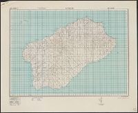
Creator:
Published / Created:
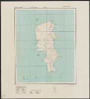
1943-44.
Call Number:
212 Sa58 1944
Container / Volume:
BRBL_00014
Image Count:
1
Resource Type:
Maps, Atlases & Globes
Alternative Title:
[Series] M789, A.M.S. M789, G.S.G.S. ; no. 4124, and GSGS (Series) ; 4124.
Description:
"Contours at 25 metres interval.", East sheet, 1943., Five classes of roads or paths are shown., In upper margin: Azores 1:50,000 ..., Index map cataloged with G. S. G. S. 4122, G9132.S2 1942.G7a., Insets: Azores islands.--Ponta Delgada [on West, and Military grid.
Publisher:
Army Map Service, U. S. Army,
Subject (Geographic):
São Miguel Island (Azores)--Maps, Topographic
Found in:
Beinecke Rare Book and Manuscript Library > San Miguel island / drawn by the War Office.
Creator:
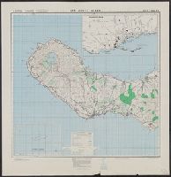
Published / Created:
1942
Call Number:
212 Sa59 1942
Container / Volume:
BRBL_00014
Image Count:
1
Resource Type:
Maps, Atlases & Globes
Alternative Title:
Geographical section, General staff. ; no. 4122 and GSGS (Series) ; 4122.
Description:
"Contours at 25 metres interval.", In upper margin: Azores 1:50,000 ..., Marginal map: Azores islands., and Military grid.
Publisher:
Army Map Service, U.S. Army,
Subject (Geographic):
Azores--Maps and Santa Maria Island (Azores)--Maps, Topographic
Found in:
Beinecke Rare Book and Manuscript Library > Santa Maria / drawn at the War Office, 1940.
Creator:
Published / Created:
1943
Call Number:
213 Sa59 1943
Container / Volume:
BRBL_00015
Image Count:
1
Resource Type:
Maps, Atlases & Globes
Alternative Title:
G.S.,G.S., ; 4118 and GSGS (Series) ; 4118.
Description:
Elevations shown by form lines and spot heights., In upper margin: Cape Verde ids. ..., Index map cataloged with G. S. G. S. 4117., and Military grid.
Publisher:
Army Map Service, U.S. Army,
Subject (Geographic):
Santa Luzia Island (Cape Verde)--Maps, Topographic
Found in:
Beinecke Rare Book and Manuscript Library > Sta. Luzia and islands / drawn at War Office, 1940, from a Portuguese map of 1932.
Creator:
Published / Created:
1943
Call Number:
213 Sa 58 1943
Container / Volume:
BRBL_00015
Image Count:
1
Resource Type:
Maps, Atlases & Globes
Alternative Title:
G.S.G.S. ; 4117 and GSGS (Series) ; 4117.
Description:
Elevations shown by form lines and spot heights., In upper margin: Cape Verde ids ..., and Military grid.
Publisher:
Army Map Service, U. S. Army,
Subject (Geographic):
Santo Antão Island (Cape Verde)--Maps, Topographic
Found in:
Beinecke Rare Book and Manuscript Library > Sto Antão / drawn at War Office, 1940, from a Portuguese map of 1930.
Branch:v1.61.8 ,Deployed:2024-06-20T11:15:04-04:00