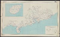
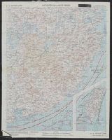
China Road Map 1:1,000,000, Series (Standard map series designation system) ; 301., and Series ; 301
Description:
"2-45.", "Compiled in 1944, from large-scale Chinese maps. Road classification based on Intelligence Reports, 1944.", "Kwangtung, China" in bottom right corner., Includes inset map indexed to political divisions and glossary., and Relief shown by altitude tints,
"A.M.S. 5301.", Cloth map (silk)., For further information see a Web site devoted to the history and identification of the AAF cloth maps., Heights and depths in meters., Includes: Index to boundarie, and Relief shown by gradient tints, contours, and spot heights.
Publisher:
Amy Map Service,
Subject (Geographic):
East Asia--Maps
Subject (Name):
UnitedStates. Army Map Service
Subject (Topic):
Military geography--Japan--Kagoshima--Maps, Military geography--Japan--Nagasaki--Maps, Military maps, Military topography--Japan--Kagoshima--Maps, and Military topography--Japan--Nagasaki--Maps
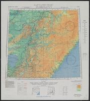
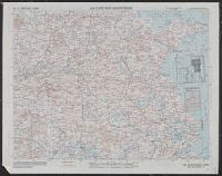
AAF cloth chart, AAF cloth chart., and Spassk-Dalʹniy
Description:
"Eastern Asia, 1:1,000,000"--Upper left corner., "N4400-E12600/400x600.", In, Includes index to boundaries, index to adjoining sheets, and conversion graph., On verso: Spassk-Dalʹniy, scale 1:1,000,000, sheet NL 53., and Relief shown by contours and spot heights.
Publisher:
The Service,
Subject (Geographic):
Harbin (China)--Maps and Primorskiĭ kraĭ (Russia)--Maps
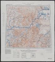
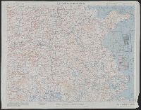
AAF cloth chart, AAF cloth chart., and Spassk-Dalʹniy
Description:
"Eastern Asia, 1:1,000,000"--Upper left corner., "N4400-E12600/400x600.", "Restricted, NL 52"--Upper right corner., Includes index to boundaries, index to adjoining sheets, and conversion graph., On verso: Spassk-Dalʹniy, scale 1:1,000,000, sheet NL 53., and Relie
Publisher:
The Service,
Subject (Geographic):
Harbin (China)--Maps and Spassk-Dalni (Russia)--Maps
A.M.S. [Series] 5301, Eastern Asia, Keijō., and Vladivostok.
Description:
"For use by War and navy Department Agencies only, not for sale or distribution., Printed on cloth (acetate rayon) with sheets back to back., Relief shown by gradient tints, contours and spot heights. Depths shown by contours and soundings., and Shows wind direc
Publisher:
Army Map Service, U.S. Army,
Subject (Geographic):
East Asia--Maps
Subject (Name):
United States. Aeronautical Chart Service and United States. Army Air Forces
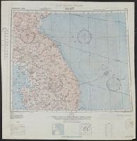
Shows roads, boundaries, railroads, power transmission lines, cities, towns, rivers, swamps, reefs and shoals.
Alternative Title:
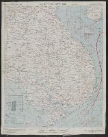
AAF cloth map. and Asiatic series
Description:
"Officers using this chart will mark hereon corrections and addition, Aviator's survival map, printed on cloth., No. 34. Southeast China -- no. 35. Northeast China., Relief shown by hachures and spot heights (China)., and Shows wind directions and ocean currents.
Publisher:
Army Map Service, U.S. Army,
Subject (Geographic):
China, Southeast--Maps and Southeast Asia--Maps
Subject (Name):
United States. Aeronautical Chart Service and United States. Army Air Forces
Subject (Topic):
Military maps, Ocean currents--China--Maps, and Winds--China--Maps
Shows roads, boundaries, railroads, power transmission lines, cities, towns, rivers, swamps, reefs and shoals.
Alternative Title:
AAF cloth map. and Asiatic series
Description:
"Officers using this chart will mark hereon corrections and additions which come to their attention and mail dire, No. 34. Southeast China -- no. 35. Northeast China., Originally issued as a restricted map., and Relief shown by hachures and spot heights (China).
Publisher:
Army Map Service, U.S. Army,
Subject (Geographic):
China, Southeast--Maps and Southeast Asia--Maps
Subject (Name):
United States. Aeronautical Chart Service and United States. Army Air Forces
Subject (Topic):
Military maps, Ocean currents--China--Maps, and Winds--China--Maps
Shows roads, boundaries, railroads, power transmission lines, cities, towns, rivers, swamps, reefs and shoals.
Alternative Title:
AAF cloth map. and Asiatic series
Description:
"Officers using this chart will mark hereon corrections and additions which come to their attention and mail direct to 'Aeronautical Chart Service, Headquarters Army Air Forces, Washington, D.C.'"--Lower and Relief shown by hachures and spot heights (China).
Publisher:
Army Map Service, U.S. Army,
Subject (Geographic):
China, Southeast--Maps and Southeast Asia--Maps
Subject (Name):
United States. Aeronautical Chart Service and United States. Army Air Forces
Subject (Topic):
Military maps, Ocean currents--China--Maps, and Winds--China--Maps
Shows roads, boundaries, railroads, power transmission lines, cities, towns, rivers, marsh, open water areas.
Alternative Title:
AAF cloth map. and Asiatic series
Description:
"Officers using this chart will mark her, Materials and list of maps in series from "US cloth maps of World War II" website., Originally issued as a restricted map., Relief shown by hachures and spot heights (China)., and Shows wind directions and ocean currents.
Publisher:
Army Map Service, U.S. Army,
Subject (Geographic):
China--Maps and Southeast Asia--Maps
Subject (Name):
United States. Aeronautical Chart Service and United States. Army Air Forces
Subject (Topic):
Military maps, Ocean currents--China--Maps, Ocean Currents--Southeast Asia--Maps, Winds--China--Maps, and Winds--Southeast Asia--Maps