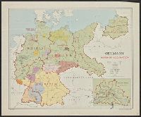
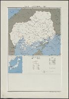
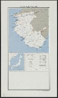
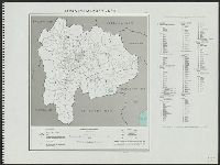
United States. Department of State. Division of Map Intelligence and Cartography
Published / Created:
1947
Call Number:
57134 1947A
Container / Volume:
BRBL_00308
Image Count:
1
Resource Type:
Maps, Atlases & Globes
Description:
"10077 February 1947.", Base from AMS L571, 1st ed., 1943, 1:250,000., Boundaries and center of population revised to Nov. 1943., and Includes ancillary map, glossary, and list of counties.
Publisher:
Dept. of State, Division of Map Intelligence and Cartography/CAHSA,
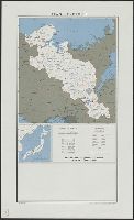
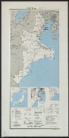
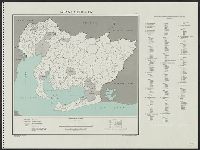
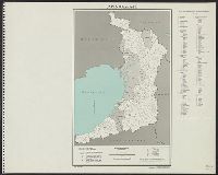
United States. Department of State. Division of Map Intelligence and Cartography
Published / Created:
[1946]
Call Number:
57144 1946
Container / Volume:
BRBL_00309
Image Count:
1
Resource Type:
Maps, Atlases & Globes
Description:
"10065 November 1946.", Base from A.M.S. L571, 1st ed., 1943, 1:250,000., Boundaries and centers of population revised to Nov. 1943., and Includes centers of population, list of gun, and location map of Japan.
Publisher:
Reproduction Branch, OSS,
Subject (Geographic):
Okayama-ken (Japan)--Maps
Subject (Name):
United States. Office of Strategic Services. Reproduction Branch
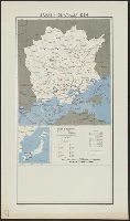
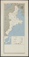
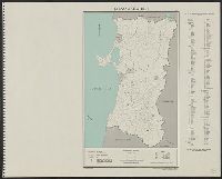
United States. Department of State. Division of Map Intelligence and Cartography
Published / Created:
[1946?]
Call Number:
5711 1946A
Container / Volume:
BRBL_00308
Image Count:
1
Resource Type:
Maps, Atlases & Globes
Description:
"10058 July 1946.", Base from A.M.S. L571, first edition, 1943 1:250,000; boundaries and centers of population revised to November 1943., and Includes ancillary map, glossary, and list of counties.
Publisher:
Dept. of State, Division of Map Intelligence and Cartography/CAHSA,
Subject (Geographic):
Aichi-ken (Japan)--Administrative and political divisions--Maps
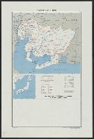
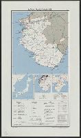
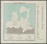
United States. Department of State. Division of Map Intelligence and Cartography
Published / Created:
[1946?]
Call Number:
57122 1946
Container / Volume:
BRBL_00308
Image Count:
1
Resource Type:
Maps, Atlases & Globes
Description:
"10064 November 1946.", Base from A.M.S. L571, first edition, 1943 1:250,000; boundaries and centers of population revised to November 1943., and Includes ancillary map, glossary, and list of gun.
Publisher:
Dept. of State, Division of Map Intelligence and Cartography/CAHSA,
Subject (Geographic):
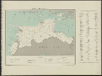
Hiroshima-ken (Japan)--Administrative and political divisions--Maps
United States. Department of State. Division of Map Intelligence and Cartography
Published / Created:
[1946?]
Call Number:
57135 1946
Container / Volume:
BRBL_00309
Image Count:
1
Resource Type:
Maps, Atlases & Globes
Description:
"10021 July 1946.", Base from A.M.S. L571, first edition, 1943 1:250,000., and Includes 3 ancillary maps, glossary, reliability table, and list of gun.
Publisher:
Dept. of State, Division of Map Intelligence and Cartography/CAHSA,
Subject (Geographic):
Mie-ken (Japan)--Administrative and political divisions--Maps
United States. Department of State. Division of Map Intelligence and Cartography
Published / Created:
[1946?]
Call Number:
57135 1946A
Container / Volume:
BRBL_00309
Image Count:
1
Resource Type:
Maps, Atlases & Globes
Description:
"10070 July 1946.", Base from A.M.S. L571, first edition, 1943 1:250,000; boundaries and centers of population revised to November 1943., and Includes ancillary map, glossary, and list of counties.
Publisher:
Dept. of State, Division of Map Intelligence and Cartography/CAHSA,
Subject (Geographic):
Mie-ken (Japan)--Administrative and political divisions--Maps
United States. Department of State. Division of Map Intelligence and Cartography
Published / Created:
[1946?]
Call Number:
57141gm 1946
Container / Volume:
BRBL_00309
Image Count:
1
Resource Type:
Maps, Atlases & Globes
Description:
"10027 July 1946.", Base from A.M.S. L571, first edition, 1943 1:250,000., and Includes 3 ancillary maps, glossary, reliability table, and list of counties.
Publisher:
Dept. of State, Division of Map Intelligence and Cartography/CAHSA,
Subject (Geographic):
Nara-ken (Japan)--Administrative and political divisions--Maps
United States. Department of State. Division of Map Intelligence and Cartography
Published / Created:
[1946?]
Call Number:
57158 1946
Container / Volume:
BRBL_00309
Image Count:
1
Resource Type:
Maps, Atlases & Globes
Description:
"10022 August 1946.", "Base from A.M.S. L571, first edition, 1943 1:250,000.", and Includes 3 ancillary maps, glossary, reliability table, and list of counties.
Publisher:
Dept. of State, Division of Map Intelligence and Cartography/CAHSA,
Subject (Geographic):
Wakayama-ken (Japan)--Administrative and political divisions--Maps
United States. Department of State. Division of Map Intelligence and Cartography
Published / Created:
[1946?]
Call Number:
57158 1946A
Container / Volume:
BRBL_00309
Image Count:
1
Resource Type:
Maps, Atlases & Globes
Description:
"10071 August 1946.", "Base from A.M.S. L571, first edition, 1943 1:250,000; boundaries and centers of population revised to November 1943.", and Includes ancillary map, glossary, and list of gun.
Publisher:
Dept. of State, Division of Map Intelligence and Cartography/CAHSA,
Subject (Geographic):
Wakayama-ken (Japan)--Administrative and political divisions--Maps
United States. Department of State. Division of Map Intelligence and Cartography
Published / Created:
1947
Call Number:
5711 1947
Container / Volume:
BRBL_00308
Image Count:
1
Resource Type:
Maps, Atlases & Globes
Alternative Title:
Aichi-ken
Description:
"10222 April 1947.", "Base map: Aichi-ken, Dai Nippon Bunken Chizu, Tökyō, 1938. (Base map contains scale errors up to 15 per cent.)", "Boundaries revised from Japanese General Staff 1:50,000.", and "Code used for the Ken, Gun, and Shi is based on that used on
Publisher:
Dept. of State, Map Division,
Subject (Geographic):
Aichi-ken (Japan)--Administrative and political divisions--Maps
United States. Department of State. Division of Map Intelligence and Cartography
Published / Created:
1947
Call Number:
57112 1947
Container / Volume:
BRBL_00308
Image Count:
1
Resource Type:
Maps, Atlases & Globes
Alternative Title:
Akita-ken
Description:
"10204 January 1947.", "Base map: Akita-ken, Dai Nippon Bunken Chizu, Tökyō, 1938.", "Boundaries revised from Japanese General Staff 1:50,000.", "Code used for the Ken, Gun, and Shi is based on that used on A.M.S. 1:250,000 series and gazetteer.", and "Map no.
Publisher:
Dept. of State, Map Division,
Subject (Geographic):
Akita-ken (Japan)--Administrative and political divisions--Maps
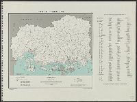
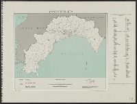
United States. Department of State. Division of Map Intelligence and Cartography
Published / Created:
1946
Call Number:
57113 1947
Container / Volume:
BRBL_00308
Image Count:
1
Resource Type:
Maps, Atlases & Globes
Alternative Title:
Aomori-ken
Description:
"10201 September 1946.", "Base map: Aomori-ken, Dai Nippon Bunken Chizu, Tökyō, 1938.", "Boundaries revised from Japanese General Staff 1:50,000.", "Code used for the Ken, Gun, and Shi is based on that used on A.M.S. 1:250,000 series and gazetteer.", and "Map n
Publisher:
Dept. of State, Map Division,
Subject (Geographic):
Aomori-ken (Japan)--Administrative and political divisions--Maps
United States. Department of State. Division of Map Intelligence and Cartography
Published / Created:
1947
Call Number:
5733 1947
Container / Volume:
BRBL_00310
Image Count:
1
Resource Type:
Maps, Atlases & Globes
Alternative Title:
Ehime-ken
Description:
"10237 November 1947.", "Base map: Ehime-ken, Dai Nippon Bunken Chizu, Tökyō, 1938. (Base map contains slight errors, especially in peripheral areas.)", "Boundaries revised from Japanese General Staff 1:50,000.", and "Code used for the ken, gun, and shi is bas
Publisher:
Dept. of State, Map Division,
Subject (Geographic):
Ehime-ken (Japan)--Administrative and political divisions--Maps
United States. Department of State. Division of Map Intelligence and Cartography
Published / Created:
1947
Call Number:
5722 1947
Container / Volume:
BRBL_00310
Image Count:
1
Resource Type:
Maps, Atlases & Globes
Alternative Title:
Ehime-ken
Description:
"10237 November 1947.", "Base map: Ehime-ken, Dai Nippon Bunken Chizu, Tökyō, 1938. (Base map contains slight errors, especially in peripheral areas.)", "Boundaries revised from Japanese General Staff 1:50,000.", and "Code used for the ken, gun, and shi is bas
Publisher:
Dept. of State, Map Division,
Subject (Geographic):
Ehime-ken (Japan)--Administrative and political divisions--Maps
United States. Department of State. Division of Map Intelligence and Cartography
Published / Created:
1947
Call Number:
57116 1947
Container / Volume:
BRBL_00308
Image Count:
1
Resource Type:
Maps, Atlases & Globes
Alternative Title:
Fukui-ken
Description:
"10217 January 1947.", "Base map: Fukui-ken, Dai Nippon Bunken Chizu, Tökyō, 1938. (Slight errors in scale may exist, especially in peripheral areas.)", "Boundaries revised from Japanese General Staff 1:50,000.", and "Code used for the Ken, Gun, and Shi is bas
Publisher:
Dept. of State, Map Division,
Subject (Geographic):
Fukui-ken (Japan)--Administrative and political divisions--Maps
United States. Department of State. Division of Map Intelligence and Cartography
Published / Created:
1947
Call Number:
5731 1947
Container / Volume:
BRBL_00310
Image Count:
1
Resource Type:
Maps, Atlases & Globes
Alternative Title:
Fukuoka-ken
Description:
"10239 November 1947.", "Base map: Fukuoka-ken, Dai Nippon Bunken Chizu, Tökyō, 1938. (Base map contain slight errors in scale, especially in peripheral areas.)", "Boundaries revised from Japanese General Staff 1:50,000.", and "Code used for the ken, gun, and
Publisher:
Dept. of State, Map Division,
Subject (Geographic):
Fukuoka-ken (Japan)--Administrative and political divisions--Maps
United States. Department of State. Division of Map Intelligence and Cartography
Published / Created:
1947
Call Number:
57118 1947
Container / Volume:
BRBL_00308
Image Count:
1
Resource Type:
Maps, Atlases & Globes
Alternative Title:
Fukushima-ken
Description:
"10206 February 1947.", "Base map: Fukushima-ken, Dai Nippon Bunken Chizu, Tökyō, 1938.", "Boundaries revised from Japanese General Staff 1:50,000.", "Code used for the Ken, Gun, and Shi is based on that used on A.M.S. 1:250,000 series and gazetteer.", and "Map
Publisher:
Dept. of State, Map Division,
Subject (Geographic):
Fukushima-ken (Japan)--Administrative and political divisions--Maps
United States. Department of State. Division of Map Intelligence and Cartography
Published / Created:
1947
Call Number:
57119 1947
Container / Volume:
BRBL_00308
Image Count:
1
Resource Type:
Maps, Atlases & Globes
Alternative Title:
Gifu-ken
Description:
"10220 January 1947.", "Base map: Gifu-ken, Dai Nippon Bunken Chizu, Tökyō, 1938.", "Boundaries revised from Japanese General Staff 1:50,000.", "Code used for the Ken, Gun, and Shi is based on that used on A.M.S. 1:250,000 series and gazetteer.", and "Map no. 2
Publisher:
Dept. of State, Map Division,
Subject (Geographic):
Gifu-ken (Japan)--Administrative and political divisions--Maps
United States. Department of State. Division of Map Intelligence and Cartography
Published / Created:
1947
Call Number:
57121 1947
Container / Volume:
BRBL_00308
Image Count:
1
Resource Type:
Maps, Atlases & Globes
Alternative Title:
Gumma-ken
Description:
"10209 February 1947.", "Base map: Gumma-ken, Dai Nippon Bunken Chizu, Tökyō, 1938.", "Boundaries revised from Japanese General Staff 1:50,000.", "Code used for the Ken, Gun, and Shi is based on that used on A.M.S. 1:250,000 series and gazetteer.", and "Map no.
Publisher:
Dept. of State, Map Division,
Subject (Geographic):
Gumma-ken (Japan)--Administrative and political divisions--Maps
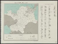
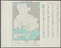
United States. Department of State. Division of Map Intelligence and Cartography
Published / Created:
1947
Call Number:
57122 1947
Container / Volume:
BRBL_00308
Image Count:
1
Resource Type:
Maps, Atlases & Globes
Alternative Title:
Hiroshima-ken
Description:
"10233 April 1947.", "Base map: Hiroshima-ken, Dai Nippon Bunken Chizu, Tökyō, 1938. (Base map contains scale errors up to 10 per cent.)", and "Boundaries revised from Japanese General Staff 1:50,000."
Publisher:
Dept. of State, Map Division,
Subject (Geographic):
Hiroshima-ken (Japan)--Administrative and political divisions--Maps
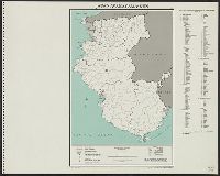
United States. Department of State. Division of Map Intelligence and Cartography
Published / Created:
1947
Call Number:
57124 1947
Container / Volume:
BRBL_00308
Image Count:
1
Resource Type:
Maps, Atlases & Globes
Alternative Title:
Hyōgo-ken
Description:
"10227 February 1947.", "Base map: Hyōgo-ken, Dai Nippon Bunken Chizu, Tökyō, 1938. (Base map contains scale errors up to 10 per cent.)", "Boundaries revised from Japanese General Staff 1:50,000.", and "Code used for the Ken, Gun, and Shi is based on that use
Publisher:
Dept. of State, Map Division,
Subject (Geographic):
Hyōgo-ken (Japan)--Administrative and political divisions--Maps
United States. Department of State. Division of Map Intelligence and Cartography
Published / Created:
1947
Call Number:
5732 1947
Container / Volume:
BRBL_00310
Image Count:
1
Resource Type:
Maps, Atlases & Globes
Alternative Title:
Kagoshima-ken
Description:
"10245 April 1947.", "Base map: Kagoshima-ken, Dai Nippon Bunken Chizu, Tökyō, 1938. (Base map contain slight errors in scale, especially in peripheral areas.)", "Boundaries revised from Japanese General Staff 1:50,000.", and "Code used for the ken, gun, and s
Publisher:
Dept. of State, Map Division,
Subject (Geographic):
Kagoshima-ken (Japan)--Administrative and political divisions--Maps
United States. Department of State. Division of Map Intelligence and Cartography
Published / Created:
1947
Call Number:
57131 1947
Container / Volume:
BRBL_00308
Image Count:
1
Resource Type:
Maps, Atlases & Globes
Alternative Title:
Kanagawa-ken
Description:
"10213 February 1947.", "Base map: Kanagawa-ken, Dai Nippon Bunken Chizu, Tökyō, 1938. (Slight errors in scale may exist, especially in peripheral areas.)", "Boundaries revised from Japanese General Staff 1:50,000.", and "Code used for the Ken, Gun, and Shi is
Publisher:
Dept. of State, Map Division,
Subject (Geographic):
Kanagawa-ken (Japan)--Administrative and political divisions--Maps
United States. Department of State. Division of Map Intelligence and Cartography
Published / Created:
1947
Call Number:
5726 1947
Container / Volume:
BRBL_00310
Image Count:
1
Resource Type:
Maps, Atlases & Globes
Alternative Title:
Kōchi-ken
Description:
"10238 February 1947.", "Base map: Kōchi-ken, Dai Nippon Bunken Chizu, Tökyō, 1938. (Base map contains slight errors in scale.)", "Boundaries revised from Japanese General Staff 1:50,000.", and "Code used for the ken, gun, and shi is based on that used on A.M
Publisher:
Dept. of State, Map Division,
Subject (Geographic):
Kōchi-ken (Japan)--Administrative and political divisions--Maps
United States. Department of State. Division of Map Intelligence and Cartography
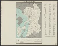
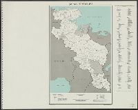
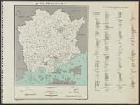
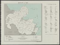
Published / Created:
1947
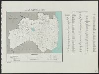
Call Number:
57134 1947
Container / Volume:
BRBL_00308
Image Count:
1
Resource Type:
Maps, Atlases & Globes
Alternative Title:
Kyōto-fu
Description:
"10225 February 1947.", "Base map: Kyōto-fu, Dai Nippon Bunken Chizu, Tökyō, 1938. (Base map contains scale errors up to 10 per cent.)", "Boundaries revised from Japanese General Staff 1:50,000.", and "Code used for the Ken, Gun, and Shi is based on that used
Publisher:
Dept. of State, Map Division,
Subject (Geographic):
Kyōto-fu (Japan)--Administrative and political divisions--Maps
United States. Department of State. Division of Map Intelligence and Cartography
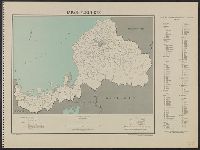
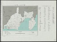
Published / Created:
1947
Call Number:
57135 1947
Container / Volume:
BRBL_00309
Image Count:
1
Resource Type:
Maps, Atlases & Globes
Alternative Title:
Mie-ken
Description:
"10223 February 1947.", "Base map: Mie-ken, Dai Nippon Bunken Chizu, Tökyō, 1938. (Base map contains scale errors, especially in peripheral areas.)", "Boundaries revised from Japanese General Staff 1:50,000.", and "Code used for the Ken, Gun, and Shi is based
Publisher:
Dept. of State, Map Division,
Subject (Geographic):
Mie-ken (Japan)--Administrative and political divisions--Maps
United States. Department of State. Division of Map Intelligence and Cartography
Published / Created:
1947
Call Number:
57136 1947
Container / Volume:
BRBL_00309
Image Count:
1
Resource Type:
Maps, Atlases & Globes
Alternative Title:
Miyagi-ken
Description:
"10203 February 1947.", "Base map: Miyagi-ken, Dai Nippon Bunken Chizu, Tökyō, 1938. (Base map contains slight errors in scale, especially in peripheral areas.)", "Boundaries revised from Japanese General Staff 1:50,000.", and "Code used for the Ken, Gun, and
Publisher:
Dept. of State, Map Division,
Subject (Geographic):
Miyagi-ken (Japan)--Administrative and political divisions--Maps
United States. Department of State. Division of Map Intelligence and Cartography
Published / Created:
1947
Call Number:
5735 1947
Container / Volume:
BRBL_00310
Image Count:
1
Resource Type:
Maps, Atlases & Globes
Alternative Title:
Nagasaki-ken
Description:
"10241 April 1947.", "Base map: Nagasaki-ken, Dai Nippon Bunken Chizu, Tökyō, 1938. (Base map contain scale errors up to 10 per cent.)", "Boundaries revised from Japanese General Staff 1:50,000.", and "Code used for the ken, gun, and shi is based on that used
Publisher:
Dept. of State, Map Division,
Subject (Geographic):
Nagasaki-ken (Japan)--Administrative and political divisions--Maps
United States. Department of State. Division of Map Intelligence and Cartography
Published / Created:
1947
Call Number:
57141 1947
Container / Volume:
BRBL_00309
Image Count:
1
Resource Type:
Maps, Atlases & Globes
Alternative Title:
Nara-ken
Description:
"10228 February 1947.", "Base map: Nara-ken, Dai Nippon Bunken Chizu, Tökyō, 1938. (Base map contains scale errors up to 20 per cent.)", "Boundaries revised from Japanese General Staff 1:50,000.", and "Code used for the Ken, Gun, and Shi is based on that used
Publisher:
Dept. of State, Map Division,
Subject (Geographic):
Nara-ken (Japan)--Administrative and political divisions--Maps
United States. Department of State. Division of Map Intelligence and Cartography
Published / Created:
1947
Call Number:
57144 1947
Container / Volume:
BRBL_00309
Image Count:
1
Resource Type:
Maps, Atlases & Globes
Alternative Title:
Okayama-ken
Description:
"10232 April 1947.", "Base map: Okayama-ken, Dai Nippon Bunken Chizu, Tökyō, 1938. (Base map contains scale errors up to 20 per cent.)", "Boundaries revised from Japanese General Staff 1:50,000.", and "Code used for the Ken, Gun, and Shi is based on that used
Publisher:
Dept. of State, Map Division,
Subject (Geographic):
Okayama-ken (Japan)--Administrative and political divisions--Maps
United States. Department of State. Division of Map Intelligence and Cartography
Published / Created:
1947
Call Number:
577 1947
Container / Volume:
BRBL_00313
Image Count:
1
Resource Type:
Maps, Atlases & Globes
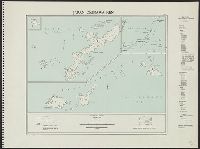
Alternative Title:
Okinawa-ken
Description:
"10246 April 1947.", "Base map: Okinawa-ken, Dai Nippon Bunken Chizu, Tökyō, 1938.", "Boundaries revised from Japanese General Staff 1:50,000.", "Code used for the ken, gun, and shi is based on that used on A.M.S. 1:250,000 series and gazetteer.", and "Map no.
Publisher:
Dept. of State, Map Division,
Subject (Geographic):
Okinawa-ken (Japan)--Administrative and political divisions--Maps
United States. Department of State. Division of Map Intelligence and Cartography
Published / Created:
1947
Call Number:
5736 1947
Container / Volume:
BRBL_00311
Image Count:
1
Resource Type:
Maps, Atlases & Globes
Alternative Title:
Ōita-ken
Description:
"10243 April 1947.", "Base map: Ōita-ken, Dai Nippon Bunken Chizu, Tökyō, 1938. (Base map contain slight errors in scale, especially in peripheral areas.)", "Boundaries revised from Japanese General Staff 1:50,000.", and "Code used for the ken, gun, and shi i
Publisher:
Dept. of State, Map Division,
Subject (Geographic):
Ōita-ken (Japan)--Administrative and political divisions--Maps
United States. Department of State. Division of Map Intelligence and Cartography
Published / Created:
1947
Call Number:
57146 1947
Container / Volume:
BRBL_00309
Image Count:
1
Resource Type:
Maps, Atlases & Globes
Alternative Title:
Ōsaka-fu
Description:
"10226 February 1947.", "Base map: Ōsaka-fu, Dai Nippon Bunken Chizu, Tökyō, 1938.", "Boundaries revised from Japanese General Staff 1:50,000.", "Code used for the Ken, Gun, and Shi is based on that used on A.M.S. 1:250,000 series and gazetteer.", and "Map no.
Publisher:
Dept. of State, Map Division,
Subject (Geographic):
Ōsaka-fu (Japan)--Administrative and political divisions--Maps
United States. Department of State. Division of Map Intelligence and Cartography
Published / Created:
1947
Call Number:
57148 1947
Container / Volume:
BRBL_00309
Image Count:
1
Resource Type:
Maps, Atlases & Globes
Alternative Title:
Saitama-ken
Description:
"10210 April 1947.", "Base map: Saitama-ken, Dai Nippon Bunken Chizu, Tökyō, 1938.", "Boundaries revised from Japanese General Staff 1:50,000.", "Code used for the Ken, Gun, and Shi is based on that used on A.M.S. 1:250,000 series and gazetteer.", and "Map no.
Publisher:
Dept. of State, Map Division,
Subject (Geographic):
Saitama-ken (Japan)--Administrative and political divisions--Maps
United States. Department of State. Division of Map Intelligence and Cartography
Published / Created:
1947
Call Number:
57149 1947
Container / Volume:
BRBL_00309
Image Count:
1
Resource Type:
Maps, Atlases & Globes
Alternative Title:
Shiga-ken
Description:
"10224 January 1947.", "Base map: Okinawa-ken, Dai Nippon Bunken Chizu, Tökyō, 1938.", "Boundaries revised from Japanese General Staff 1:50,000.", "Code used for the Ken, Gun, and Shi is based on that used on A.M.S. 1:250,000 series and gazetteer.", and "Map no
Publisher:
Dept. of State, Map Division,
Subject (Geographic):
Shiga-ken (Japan)--Administrative and political divisions--Maps
United States. Department of State. Division of Map Intelligence and Cartography
Published / Created:
1947
Call Number:
57152 1947
Container / Volume:
BRBL_00309
Image Count:
1
Resource Type:
Maps, Atlases & Globes
Alternative Title:
Shizuoka-ken
Description:
"10221 February 1947.", "Base map: Shizuoka-ken, Dai Nippon Bunken Chizu, Tökyō, 1938.", "Boundaries revised from Japanese General Staff 1:50,000.", "Code used for the ken, gun, and shi is based on that used on A.M.S. 1:250,000 series and gazetteer.", and "Map
Publisher:
Dept. of State, Map Division
Subject (Geographic):
Shizuoka-ken (Japan)--Administrative and political divisions--Maps
United States. Department of State. Division of Map Intelligence and Cartography
Published / Created:
1947
Call Number:
5728 1947
Container / Volume:
BRBL_00310
Image Count:
1
Resource Type:
Maps, Atlases & Globes
Alternative Title:
Tokushima-ken
Description:
"10235 April 1947.", "Base map: Tokushima-ken, Dai Nippon Bunken Chizu, Tökyō, 1938. (Base map contains slight errors in scale, especially in peripheral areas.)", "Boundaries revised from Japanese General Staff 1:50,000.", and "Code used for the ken, gun, and
Publisher:
Dept. of State, Map Division,
Subject (Geographic):
Tokushima-ken (Japan)--Administrative and political divisions--Maps
United States. Department of State. Division of Map Intelligence and Cartography
Published / Created:
1947
Call Number:
57158 1947
Container / Volume:
BRBL_00310
Image Count:
1
Resource Type:
Maps, Atlases & Globes
Alternative Title:
Wakayama-ken
Description:
"10229 January 1947.", "Base map: Wakayama-ken, Dai Nippon Bunken Chizu, Tökyō, 1938. (Base map contains slight errors in scale.)", "Boundaries revised from Japanese General Staff 1:50,000.", and "Code used for the ken, gun, and shi is based on that used on A.
Publisher:
Dept. of State, Map Division
Subject (Geographic):
Wakayama-ken (Japan)--Administrative and political divisions--Maps
United States. Department of State. Division of Map Intelligence and Cartography
Published / Created:
1947
Call Number:
57159 1947
Container / Volume:
BRBL_00310
Image Count:
1
Resource Type:
Maps, Atlases & Globes
Alternative Title:
Yamagata-ken
Description:
"10205 January 1947.", "Base map: Yamagata-ken, Dai Nippon Bunken Chizu, Tökyō, 1938.", "Boundaries revised from Japanese General Staff 1:50,000.", "Code used for the ken, gun, and shi is based on that used on A.M.S. 1:250,000 series and gazetteer.", and "Map n
Publisher:
Dept. of State, Map Division
Subject (Geographic):
Yamagata-ken (Japan)--Administrative and political divisions--Maps
United States. Department of State. Division of Map Intelligence and Cartography
Published / Created:
1947
Call Number:
57161 1947
Container / Volume:
BRBL_00310
Image Count:
1
Resource Type:
Maps, Atlases & Globes
Alternative Title:
Yamaguchi-ken
Description:
"10234 February 1947.", "Base map: Yamaguchi-ken, Dai Nippon Bunken Chizu, Tökyō, 1938. (Base map contains slight errors in scale, especially in peripheral areas.)", "Boundaries revised from Japanese General Staff 1:50,000.", and "Code used for the ken, gun, a
Publisher:
Dept. of State, Map Division
Subject (Geographic):
Yamaguchi-ken (Japan)--Administrative and political divisions--Maps
United States. Department of State. Division of Map Intelligence and Cartography
Published / Created:
1947
Call Number:
57162 1947
Container / Volume:
BRBL_00310
Image Count:
1
Resource Type:
Maps, Atlases & Globes
Alternative Title:
Yamanashi-ken
Description:
"10218 February 1947.", "Base map: Yamanashi-ken, Dai Nippon Bunken Chizu, Tökyō, 1938. (Base map contains slight errors in scale, especially in peripheral areas.)", "Boundaries revised from Japanese General Staff 1:50,000.", and "Code used for the ken, gun, a
Publisher:
Dept. of State, Map Division
Subject (Geographic):
Yamanashi-ken (Japan)--Administrative and political divisions--Maps