Adam and Charles Black (Firm) Aikman, George, engraver Barlow, Peter, 1776-1862
Published / Created:
1854]
Call Number:
11 1854
Container / Volume:
BRBL_00009
Image Count:
1
Resource Type:
Maps, Atlases & Globes
Description:
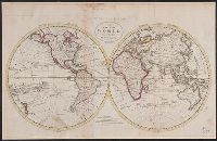
In lower right margin: Engd. by G. Aikman., Plate III-I from: General atlas of the world. Edinburgh : A. and C. Black, 1854., Prime meridian: Greenwich., and World map showing magnetic curves.
United States. Department of the Treasury. Bureau of Statistics
Published / Created:
[1900]
Call Number:
BrSides Double Folio 2019 2
Image Count:
1
Resource Type:
Maps, Atlases & Globes
Description:
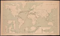
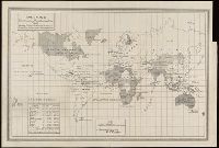
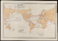
Also shows area and population notes, railroads in colonies, submarine cables, steamship lines with distances, and canals., Includes table of submarine telegraph connections., and Manuscript note in lower right corner: Colonial systems. Scale statement written in manuscript at bottom.
Decorated with sea monsters, mermaids, exotic animals, and cannibals, this wood cut map provides a marked contrast to the simplistic diagrams considered the earliest printed world maps. While the latter presented a world view based in Judeo-Christian theo
Alternative Title:
Typus cosmographicus universalis and Typvs cosmographicvs vniversalis
Description:
Appears in Johann Huttich's Novus orbis regionum. Basel. 1532. and Relief shown pictorially.
Publisher:
[publisher not identified],
Subject (Name):
Holbein, Hans, 1497-1543 and Huttich, Johann, 1480?-1544. Novus orbis regionum.