From The Gentleman's magazine and historical chronicle (November, 1776), vol. 46., Prime meridian: London., Relief shown pictorially., Sheet measures 21.2 x 25 cm. Cross Collection no. 199., and Shows Fairfield, New Haven, and New London counties in Connecticut, towns, roads, rivers, and place names in Connecticut, Rhode Island and part of Long Island. Includes copper mine near Simsbury, Conn. Also shows relief.
Publisher:
Gentleman's Magazine,
Subject (Geographic):
Connecticut--Maps--Early works to 1800, Long Island Sound (N.Y. and Conn.)--Maps--Early works to 1800, and Rhode Island--Maps--Early works to 1800
From The Gentleman's magazine and historical chronicle (November, 1776), vol. 46., Prime meridian: London., Relief shown pictorially., Sheet measures 22.2 x 26.3 cm. Cross Collection no. 200., and Shows Fairfield, New Haven, and New London counties in Connecticut, towns, roads, rivers, and place names in Connecticut, Rhode Island and part of Long Island. Includes copper mine near Simsbury, Conn. Also shows relief.
Publisher:
Gentleman's Magazine,
Subject (Geographic):
Connecticut--Maps--Early works to 1800, Long Island Sound (N.Y. and Conn.)--Maps--Early works to 1800, and Rhode Island--Maps--Early works to 1800
From Robert Sayer and John Bennett's American military pocket atlas (1776)., Imperfect: torn at bottom middle along fold, with some loss of text. Manuscript number of vero: 3., Relief shown pictorially., and Watermark.
Subject (Geographic):
NewEngland--Maps--Early works to 1800
Subject (Name):
Holland, Samuel, 1728-1801, Pownall, Thomas, 1722-1805, and Robert Sayer and John Bennett (Firm). American military pocket atlas
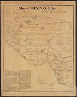
Ms. note "Yale College, from Cyrus Woodman, Cambridge Mass: September 26, 1871". and Surveyor's map showing divisions, ranges and lots, roads, railroads, sites of houses prior to 1800, etc.
Publisher:
NewEngland Lith. Co. ,
Subject (Geographic):
Buxton (Maine)--Maps
Subject (Name):
Woodman, Cyrus,--1814-1889--Presentation inscription to Yale College
"Observations on which this map is grounded.", Copy 2: Imperfect: southern sheet wanting., Includes compilation data and insets of "A plan of the town of Boston" and "A plan of the town of Boston Harbor from an accurate sur, and Prime meridian: London and Ferro.
Publisher:
November 29th 1774 Published according to Act by Thos. Jefferys geographer to His Royal Highness the Prince of Wales near Charing Cross,
"Observations on which this map is grounded.", Dissected and mounted on linen., Includes compilation data and insets of "A plan of the town of Boston" and "A plan of the town of Boston Harbor from, Prime meridian: London and Ferro., and Relief shown pictorially.
Publisher:
November 29th 1774 Published according to Act by Thos. Jefferys geographer to His Royal Highness the Prince of Wales near Charing Cross,
"Observations on which this map is grounded.", Copy 2: Imperfect: southern sheet wanting., Includes compilation data and insets of "A plan of the town of Boston" and "A plan of the town of Boston Harbor from an accurate survey," ca. 1:150,000., and Prime meridia
Publisher:
November 29th 1774 Published according to Act by Thos. Jefferys geographer to His Royal Highness the Prince of Wales near Charing Cross,
"Observations on which this map is grounded.", Copy 1: Dissected and mounted on linen., Includes compilation data and insets of "A plan of the town of Boston" and "A plan of the town of Boston Harbor from an accurate survey," ca. 1:150,000., and Prime meridian:
Publisher:
November 29th 1774 Published according to Act by Thos. Jefferys geographer to His Royal Highness the Prince of Wales near Charing Cross,
Includes eastern Connecticut ; Massachusetts as far north as Boston, including Cape Cod, Martha's Vineyard, and Nantucket ; and the eastern end of Long Island.
Alternative Title:
Colony of Rhode Island and Rhode Island
Description:
"London Magazine 1778"--Top margin., From The London Magazine (November 1778)., Publisher from bottom margin., Relief shown pictorially., and Sheet measures 21 x 28.4 cm. Inscription on verso: William Akers. Cross Collection no. 198.
Publisher:
Printed for R. Baldwin at the Rose, Pater Noster Row,
Subject (Geographic):
NewEngland--Maps--Early works to 1800
Subject (Name):
Akers, William--Autograph and Baldwin, R. (Robert), 1737-1810