Skip to search
Skip to main content
Skip to first result
Search
You Searched For
Extent of Digitization
Completely digitized
Genre
Maps
New Search
Search Results
Creator:
Published / Created:
[1921]
Call Number:
1992 Folio 7
Image Count:
1
Resource Type:
Books, Journals & Pamphlets
Found in:
Beinecke Rare Book and Manuscript Library > Librairie six, 5, avenue Lowendal, Paris 7e, Exposition dada Man Ray, du 3 au 31 decembre 1921 ...
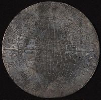
Creator:
Published / Created:
[1589]
Call Number:
Taylor 15
Image Count:
5
Resource Type:
Maps, Atlases & Globes
Found in:
Beinecke Rare Book and Manuscript Library > [Silver map of the world showing the track of Sir Francis Drakes circumnavigation engraved or struck on a flat silver disc by Michael Mercator]
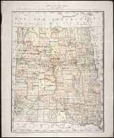
Creator:
Published / Created:
c1884
Call Number:
BrSides Zc35 876rae
Image Count:
1
Resource Type:
Maps, Atlases & Globes
Found in:
Beinecke Rare Book and Manuscript Library > Map of Dakota / printed expressly for E.P. Gates, president Merchants Bank and negotiator of farm loans, Grand Forks, Dakota
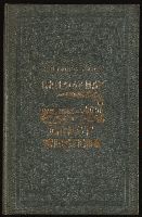
Creator:
Published / Created:
undated
Call Number:
Zc18 A11 856db
Image Count:
2
Resource Type:
Books, Journals & Pamphlets
Found in:
Beinecke Rare Book and Manuscript Library > D.B. Cooke & Cos great western railway guide : exhibiting all stations with distances from each other.
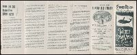
Creator:
Published / Created:
1934]
Call Number:
ZZa L588 G934
Image Count:
2
Resource Type:
Maps, Atlases & Globes
Found in:
Beinecke Rare Book and Manuscript Library > A map of Sinclair Lewis United States as it appears in his novels
Published / Created:
[1897?]
Call Number:
Zc86 897cq
Image Count:
5
Resource Type:
Books, Journals & Pamphlets
Found in:
Beinecke Rare Book and Manuscript Library > Copper River, Alaska : Pacific Steam Whaling Co., all American Route ...
Creator:
Published / Created:
1875-1908
Call Number:
WA MSS S-1314
Collection Title:
Charles F. Bates papers
Container / Volume:
Box 15 | Folder 200
Image Count:
109
Found in:
Beinecke Rare Book and Manuscript Library > [Scrapbook]
Creator:
Published / Created:
[United States : and 1989]
Call Number:
BrSides Folio 2005 20
Image Count:
1
Resource Type:
Maps, Atlases & Globes
Found in:
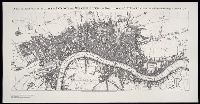
Beinecke Rare Book and Manuscript Library > A new and exact plan of the cities of London and Westminster, and borough of Southwark, with the additional buildings to the year 1756
Creator:
Published / Created:
1806 January
Call Number:
ZZ35 5 4
Image Count:
1
Resource Type:
Maps, Atlases & Globes
Found in:
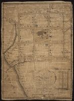
Beinecke Rare Book and Manuscript Library > A plan of the town of New Haven with all the buildings in 1748 taken by the Hon. Gen. Wadsworth of Durham ... : respectfully inscribed to the Connecticut Academy of Arts and Sciences / by ... Wm. Lyon
Creator:
Published / Created:
1860 February 17-November 26
Call Number:
WA MSS S-2490
Collection Title:
William Downie papers relating to exploration of British Columbia
Container / Volume:
Box 1 | 1a
Image Count:
153
Resource Type:
Archives or Manuscripts
Found in:
Beinecke Rare Book and Manuscript Library > Family Register, manuscript diary
Creator:
Published / Created:
[1886?]
Call Number:
BrSides Zc39 886fr
Image Count:
2
Resource Type:
Books, Journals & Pamphlets
Found in:
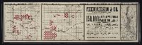
Beinecke Rare Book and Manuscript Library > Frederiksen & Co. own and offer for sale in central Kansas : 150,000 acres of the choicest farming lands ...
Creator:
Published / Created:
1795
Call Number:
Osborn pc259
Image Count:
4
Resource Type:
Maps, Atlases & Globes
Found in:
Beinecke Rare Book and Manuscript Library > Bowles's European geographical amusement, or, Game of geography ; designed from The grand tour of Europe, by Dr. Nugent
Creator:
Published / Created:
ca. 1892]
Call Number:
Zc70 885nof 949
Image Count:
3
Resource Type:
Maps, Atlases & Globes
Found in:
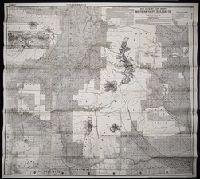
Beinecke Rare Book and Manuscript Library > Sectional land map showing the lands of the Northern Pacific Railroad Co. in western Washington and northern Oregon : with condensed information relating to the Pacific Northwest
Creator:
Published / Created:
[1680?]
Call Number:
1973 Folio 10
Image Count:
1
Resource Type:
Maps, Atlases & Globes
Found in:
Beinecke Rare Book and Manuscript Library > Insula sive regnum Siciliae
Creator:
Published / Created:
[ca. 1670]
Call Number:
1973 Folio 10
Image Count:
1
Resource Type:
Maps, Atlases & Globes
Found in:
Beinecke Rare Book and Manuscript Library > Barbaria
Creator:
Published / Created:
1680
Call Number:
1973 Folio 10
Image Count:
1
Resource Type:
Maps, Atlases & Globes
Found in:
Beinecke Rare Book and Manuscript Library > A mapp of all the world in two hemispheres in which are exactly described all the parts of the earth and seas
Creator:
Published / Created:
1680
Call Number:
1973 Folio 10
Image Count:
1
Resource Type:
Maps, Atlases & Globes
Found in:
Beinecke Rare Book and Manuscript Library > Europe divided into its principall states, which are subdivided into their principall provinces
Creator:
Published / Created:
[ca. 1700]
Call Number:
1973 Folio 10
Image Count:
1
Resource Type:
Maps, Atlases & Globes
Found in:
Beinecke Rare Book and Manuscript Library > A new mapp of the sea coasts of England, Scotland, and Ireland: with the adjacent coasts of France, Holand, Denmark & Norway, shewing the scituation and distance of the several ports, harbors, havens, creeks, sands &c
Creator:
Published / Created:
[1689?]
Call Number:
1973 Folio 10
Image Count:
1
Resource Type:
Maps, Atlases & Globes
Found in:
Beinecke Rare Book and Manuscript Library > A new mapp of the kingdome of England and Wales: containing all the cities, market towns, with the roades from town to town, and the numbers of reputed miles between them, are given by inspection without scale or compass
Creator:
Published / Created:
1700
Call Number:
1973 Folio 10
Image Count:
1
Resource Type:
Maps, Atlases & Globes
Found in:
Beinecke Rare Book and Manuscript Library > This actuall survey of London, Westminster & Southwark is humbly dedicated to ye Ld. Mayor [and] Court of Aldermen by Ro. Morden, Phil. Lea, Chr. Browne
Creator:
Published / Created:
[169-?]
Call Number:
1973 Folio 10
Image Count:
1
Resource Type:
Maps, Atlases & Globes
Found in:
Beinecke Rare Book and Manuscript Library > A new chart of the sea coasts of France: together with the English Chanell describing ye severall harbors, sands, rocks, and anchoridges, etc. on the said coasts
Creator:
Published / Created:
[ca. 1689]
Call Number:
1973 Folio 10
Image Count:
1
Resource Type:
Maps, Atlases & Globes
Found in:
Beinecke Rare Book and Manuscript Library > Exactissima Regni Scotiae tabula tam in septentrionalem et meriodionalem quam in minores earundem provincias, insulasq[ue], ei undique praetensas accurate divisa
Creator:
Published / Created:
[ca. 1700]
Call Number:
1973 Folio 10
Image Count:
1
Resource Type:
Maps, Atlases & Globes
Found in:
Beinecke Rare Book and Manuscript Library > A new map of Ireland
Creator:
Published / Created:
[1704?]
Call Number:
1973 Folio 10
Image Count:
1
Resource Type:
Maps, Atlases & Globes
Found in:
Beinecke Rare Book and Manuscript Library > The war in Portugall and Spain: with the harbours of the Groyne, Vigo & Bayonna, Porto, Lisbon [and] St. Ubes, Cadiz, and a chart from England to the streights
Creator:
Published / Created:
[1682]
Call Number:
1973 Folio 10
Image Count:
1
Resource Type:
Maps, Atlases & Globes
Found in:
Beinecke Rare Book and Manuscript Library > Spain divided into its severall kingdoms and principalities, according as they are comprehended under the crowns of Castile and Aragon, in the possession of his Catholick Majesty and under the crown of Portugal, in the possession of the king of Portugal
Creator:
Published / Created:
[168-]
Call Number:
1973 Folio 10
Image Count:
1
Resource Type:
Maps, Atlases & Globes
Found in:
Beinecke Rare Book and Manuscript Library > Principality of Catalonia: in which are comprehended the counties of Rossillion and of Cerdagne divided into its severall vigueries or provost-ship
Creator:
Published / Created:
[168-]
Call Number:
1973 Folio 10
Image Count:
1
Resource Type:
Maps, Atlases & Globes
Found in:
Beinecke Rare Book and Manuscript Library > The kingdom of France: distinguished according to the extent of all its provinces and conquests in Spain, Italy, Germany, Flanders, Artoise, Haynoult, Namur, and Luxembourg, provinces of the low countries
Creator:
Published / Created:
[168-?]
Call Number:
1973 Folio 10
Image Count:
1
Resource Type:
Maps, Atlases & Globes
Found in:
Beinecke Rare Book and Manuscript Library > Lutetiae Parisiorum universae Galliae metropolis novissima [et] accuratissima
Creator:
Published / Created:
[ca. 1700]
Call Number:
1973 Folio 10
Image Count:
1
Resource Type:
Maps, Atlases & Globes
Found in:
Beinecke Rare Book and Manuscript Library > Gouvernement General de Languedoc: divise en ses vint deux Diocesez
Creator:
Published / Created:
1693
Call Number:
1973 Folio 10
Image Count:
1
Resource Type:
Maps, Atlases & Globes
Found in:
Beinecke Rare Book and Manuscript Library > La Suisse divisee en ses treze cantons, ses alliez [et] ses sujets
Creator:
Published / Created:
1682
Call Number:
1973 Folio 10
Image Count:
1
Resource Type:
Maps, Atlases & Globes
Found in:
Beinecke Rare Book and Manuscript Library > Italy: distinguished according to the extent of all the states, kingdoms, republicks, dukedoms, principalities etc. that doe at present divide it
Creator:
Published / Created:
[168-?]
Call Number:
1973 Folio 10
Image Count:
1
Resource Type:
Maps, Atlases & Globes
Found in:
Beinecke Rare Book and Manuscript Library > A new map of the estates of Savoy [and] Piedmont: with the countries adjacent
Creator:
Published / Created:
[ca. 1701]
Call Number:
1973 Folio 10
Image Count:
1
Resource Type:
Maps, Atlases & Globes
Found in:
Beinecke Rare Book and Manuscript Library > H. Jalliots map of the seat of war in Italy cont. ye duchyes of Milan, Mantua, Parma, etc. with the Venetian territoryes
Creator:
Published / Created:
[ca. 1680]
Call Number:
1973 Folio 10
Image Count:
1
Resource Type:
Maps, Atlases & Globes
Found in:
Beinecke Rare Book and Manuscript Library > Status ecclesiasticus et magnus ducatus Thoscanae
Creator:
Published / Created:
[ca. 1700?]
Call Number:
1973 Folio 10
Image Count:
1
Resource Type:
Maps, Atlases & Globes
Found in:
Beinecke Rare Book and Manuscript Library > A new mapp of Rome shewing its antient and present scituation
Creator:
Published / Created:
[1706?]
Call Number:
1973 Folio 10
Image Count:
1
Resource Type:
Maps, Atlases & Globes
Found in:
Beinecke Rare Book and Manuscript Library > Regnum Neapolis: in quo sunt Aprutium ulterius et citerius, Comitatus Molisius, Terra Laboris, Capitaniata Principatus ulterior et citerior, Terra Bariensis et Hidruntina, Basilicata, Calabria citerior et ulterior
Creator:
Published / Created:
[ca. 1680]
Call Number:
1973 Folio 10
Image Count:
1
Resource Type:
Maps, Atlases & Globes
Found in:
Beinecke Rare Book and Manuscript Library > Mediterranean Sea divided into its principal parts or seas
Creator:
Published / Created:
1683
Call Number:
1973 Folio 10
Image Count:
1
Resource Type:
Maps, Atlases & Globes
Found in:
Beinecke Rare Book and Manuscript Library > The states of the empire of the Turks in Europe: subdivided according to ye extent of its governments
Creator:
Published / Created:
[168-?]
Call Number:
1973 Folio 10
Image Count:
1
Resource Type:
Maps, Atlases & Globes
Found in:
Beinecke Rare Book and Manuscript Library > The kingdom of Hungary and the states that have been subject to it which are now the northern parts of Turkey in Europe
Creator:
Published / Created:
[ca. 1686]
Call Number:
1973 Folio 10
Image Count:
1
Resource Type:
Maps, Atlases & Globes
Found in:
Beinecke Rare Book and Manuscript Library > The empire of Germany divided according to the extent of all the estates, principalities and soveraignities that are or have been comprehended under the name of Germany
Creator:
Published / Created:
[ca. 1686]
Call Number:
1973 Folio 10
Image Count:
1
Resource Type:
Maps, Atlases & Globes
Found in:
Beinecke Rare Book and Manuscript Library > Part of the circle of Austria viz the Archdukedom of Austria, divided into the higher and lower
Creator:
Published / Created:
1688
Call Number:
1973 Folio 10
Image Count:
1
Resource Type:
Maps, Atlases & Globes
Found in:
Beinecke Rare Book and Manuscript Library > Part of the circle of Austria in which are the Dukedomes of Stiria, and Carinthia, of Carniola, and other heriditary countrys of the house of Austria
Creator:
Published / Created:
[ca. 1686]
Call Number:
1973 Folio 10
Image Count:
1
Resource Type:
Maps, Atlases & Globes
Found in:
Beinecke Rare Book and Manuscript Library > The circle of Bavaria subdivided into all ye territories it's composed of
Creator:
Published / Created:
1696
Call Number:
1973 Folio 10
Image Count:
1
Resource Type:
Maps, Atlases & Globes
Found in:
Beinecke Rare Book and Manuscript Library > Le cercle de Franconie : subdivise en tous les estats qui le composent
Creator:
Published / Created:
[ca. 1686]
Call Number:
1973 Folio 10
Image Count:
1
Resource Type:
Maps, Atlases & Globes
Found in:
Beinecke Rare Book and Manuscript Library > The circle of Swabia subdivided into all the territories it's composed of
Creator:
Published / Created:
1689
Call Number:
1973 Folio 10
Image Count:
1
Resource Type:
Maps, Atlases & Globes
Found in:
Beinecke Rare Book and Manuscript Library > The circle and electorat of the Rhine : subdivided into all the states that it's composed off [sic]
Creator:
Published / Created:
[ca. 1689]
Call Number:
1973 Folio 10
Image Count:
1
Resource Type:
Maps, Atlases & Globes
Found in:
Beinecke Rare Book and Manuscript Library > The course of the river Rhine : from its fountain to its runing into the sea in which is distinguish't all the estates and soveraignities which are upon it and about it
Creator:
Published / Created:
[ca. 1689]
Call Number:
1973 Folio 10
Image Count:
1
Resource Type:
Maps, Atlases & Globes
Found in:
Beinecke Rare Book and Manuscript Library > The circle of Westphalia : divided into all it's states and soveranities
Creator:
Published / Created:
[ca. 1684?]
Call Number:
1973 Folio 10
Image Count:
1
Resource Type:
Maps, Atlases & Globes
Found in:
Beinecke Rare Book and Manuscript Library > The dukedom and electorat of Brandenbourg: which is part of the circle of the higher Saxony, divided into its principall parts
Creator:
Published / Created:
[ca. 1689?]
Call Number:
1973 Folio 10
Image Count:
1
Resource Type:
Maps, Atlases & Globes
Found in:
Beinecke Rare Book and Manuscript Library > The dukedom of Pomerania : divided into it's principall parts
Branch:v1.60.98 ,Deployed:2024-04-24T10:14:36-04:00