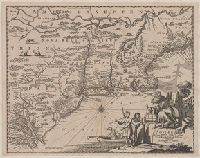
"Separate publication ca. 1676" (McCorkle 38)., Includes hand colored illustration of American Indians., Relief shown pictorially., and Verso: Partially stamped "Yale University".
Publisher:
Sould by Robert Morden ... and by William Berry ... ,
Subject (Geographic):
NewEngland--Maps--Early works to 1800
Subject (Name):
Berry, William, fl. 1669-1708 and King, Gregory, 1648-1712, engraver
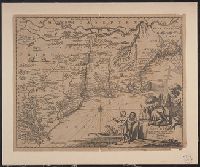
Author statement from McCorkle, p. 40., Includes ill. of animals and coat of arms., Relief shown pictorially., Verso: P. nos. "46", "45"; titles "The Description of New Neatherlands ... ", "The Description, and Verso: Stamped "Yale University Library".
Publisher:
Sold by Tho: Basset in Fleetstreet, and Richard Chiswell in St. Pauls Church Yard,
Subject (Geographic):
NewEngland--Maps--Early works to 1800
Subject (Name):
Bassett, Thomas, bookseller, Chiswell, Richard, Lamb, Francis, and Speed, John, 1552?-1629. Prospect of the most famous parts of the world
Imperfect. Verso: Stamped "Yale Horace Brown 1900S"., Inset map: "East Florida continued.", Shows areas occupied by many Native American tribes., and Top margin: "Engrav'd for Guthrie's new geographical grammar." Appears in: William Guthrie, New system
Subject (Geographic):
North America--Maps--Early works to 1800
Subject (Name):
Guthrie, William, 1708-1770. New system of modern geography
Subject (Topic):
Indians of North America--Maps--Early works to 1800
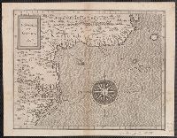
1st state. Cross collection no. 20. No. 3 of 3 maps mounted on linen., Appeared in Arnoldus Montanus's De Nieuwe en onbekende weereld., Includes ill., and Relief shown pictorially.
Publisher:
Jacob von Meurs?,
Subject (Geographic):
NewEngland--Maps--Early works to 1800
Subject (Name):
Montanus, Arnoldus, 1625?-1683. Nieuwe en onbekende weereld
Appeared in Arnoldus Montanus's De Nieuwe en onbekende weereld., Copy 2: 1st state. Uncolored. Mounted on linen. Dimensions: 29 x 37 cm., on sheet 36 x 44 cm. Verso: Stamped "Yale"., Includes ill., and Relief shown pictorially.
Publisher:
Jacob von Meurs?,
Subject (Geographic):
NewEngland--Maps--Early works to 1800
Subject (Name):
Montanus, Arnoldus, 1625?-1683. Nieuwe en onbekende weereld
Appears in the author's Descriptionis Ptolemaicae augmentum. 1597., Covers the Atlantic coast of North America from Nova Scotia to Virginia., Has watermark., In upper right: 17., and Relief shown pictorially.
Publisher:
J. Bogard],
Subject (Geographic):
Atlantic Coast (U.S.)--Maps--Early works to 1800
Subject (Name):
Bogard, Jean, d. ca. 1634 and Wytfliet, Corneille. Descriptionis Ptolemaicae augmentum
Subject (Topic):
Coasts--Maritime Provinces--Maps--Early works to 1800