Search
You Searched For
Search Results
- Published / Created:
- [1730?]
- Call Number:
- 894 1730
- Container / Volume:
- BRBL_00659
- Image Count:
- 1
- Resource Type:
- Maps, Atlases & Globes
- Found in:
- Beinecke Rare Book and Manuscript Library > ... This draught. being part of ye Spanish & Musketor Shore & the Bay of Honduras with. ye Islands adjacent; ... by ... Samuel Penthalow.
- Published / Created:
- [1730]
- Call Number:
- 18 1730A
- Container / Volume:
- BRBL_00012
- Image Count:
- 1
- Resource Type:
- Maps, Atlases & Globes
- Found in:
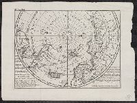
- Beinecke Rare Book and Manuscript Library > A Polar map of part of the northern hemisphere from the latitude of 40 degrees to the Pole.
- Creator:
- W. Mount and T. Page
- Published / Created:
- [between 1732 and 1749]
- Call Number:
- 71cea 1723
- Container / Volume:
- BRBL_00688
- Image Count:
- 1
- Resource Type:
- Maps, Atlases & Globes
- Found in:
- Beinecke Rare Book and Manuscript Library > A chart of the sea coast of New Found Land, New Scotland, New England, New York, New Jersey, with Virginia and Maryland.
- Published / Created:
- [1737?] [1758?]
- Call Number:
- 771 N49 1737
- Container / Volume:
- BRBL_00484
- Image Count:
- 1
- Resource Type:
- Maps, Atlases & Globes
- Found in:
- Beinecke Rare Book and Manuscript Library > A draught of New York from the Hook to New York Town by Mark Tiddeman. Printed for W. Mount and T. Page upon Tower Hill Lomdon
- Creator:
- Anville, Jean Baptiste Bourguignon d', 1697-1782
- Published / Created:
- 17--?]
- Call Number:
- 71 1769A
- Container / Volume:
- BRBL_00364
- Image Count:
- 1
- Resource Type:
- Maps, Atlases & Globes
- Found in:
- Beinecke Rare Book and Manuscript Library > A map of North America : from D'Anville, 1769.
- Creator:
- Popple, Henry, -1743
- Published / Created:
- 1733
- Call Number:
- 89 1720
- Container / Volume:
- BRBL_00697
- Image Count:
- 1
- Resource Type:
- Maps, Atlases & Globes
- Found in:
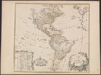
- Beinecke Rare Book and Manuscript Library > A map of the British Empire in America, with the French and Spanish settlements adjacent thereto / by Henry Popple.
- Creator:
- Moll, Herman, -1732
- Published / Created:
- [1736?]
- Call Number:
- 18 1739
- Container / Volume:
- BRBL_00682
- Image Count:
- 1
- Resource Type:
- Maps, Atlases & Globes
- Found in:
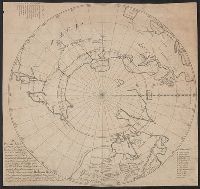
- Beinecke Rare Book and Manuscript Library > A map of the North Pole : with all the territories that lye near it, known to us &c. : according to the latest discoveries, and most exact observations : agreeable to modern history / by H. Moll geographer.
- Creator:
- Delarochette, L. (Louis), 1731-1802
- Published / Created:
- 17--?]
- Call Number:
- 70 1770
- Container / Volume:
- BRBL_00356
- Image Count:
- 1
- Resource Type:
- Maps, Atlases & Globes
- Found in:
- Beinecke Rare Book and Manuscript Library > A map of the whole continent of America : according to D'Anville & Bellin / by L. Delarochette ; Bayly, sculpt.
- Published / Created:
- [17--?]
- Call Number:
- 39 C11 1702
- Container / Volume:
- BRBL_00189
- Image Count:
- 1
- Resource Type:
- Maps, Atlases & Globes
- Found in:
- Beinecke Rare Book and Manuscript Library > A mapp of the bay and towne of Cadiz : with all it's fortifications as it was ye 15th. of August 1702, at the time of Sr. George Rooke's coming before it / H. Hulsbergh, scu.
- Published / Created:
- 1734
- Call Number:
- 771 N49 1734
- Container / Volume:
- BRBL_00713
- Image Count:
- 1
- Resource Type:
- Maps, Atlases & Globes
- Found in:
- Beinecke Rare Book and Manuscript Library > A mapp or survey of the swamp or Crupel-bush in Montgomerie Ward in the city of New York ... 1734. Copied ... 1823, 1830 ... 1899 by W.F. Osborne.