Skip to search
Skip to main content
Skip to first result
Search
You Searched For
Extent of Digitization
Completely digitized
Genre
World maps
Language
English
Search Results
Published / Created:
[1795?]
Call Number:
11 1795A
Container / Volume:
BRBL_00006
Image Count:
1
Resource Type:
Maps, Atlases & Globes
Description:
2 copies.
Subject (Geographic):
World--Maps--Early works to 1800
Found in:
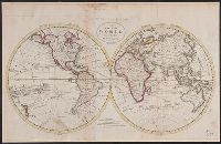
Beinecke Rare Book and Manuscript Library > A Chart of the World, According to Mercator's Projection, showing the latest discoveries of Capt. Cook.
Published / Created:
[1795?]
Call Number:
11 1795A
Container / Volume:
BRBL_00006
Image Count:
1
Resource Type:
Maps, Atlases & Globes
Description:
2 copies.
Subject (Geographic):
World--Maps--Early works to 1800
Found in:
Beinecke Rare Book and Manuscript Library > A Chart of the World, According to Mercator's Projection, showing the latest discoveries of Capt. Cook.
Published / Created:
1795
Call Number:
11 1795
Container / Volume:
BRBL_00006
Image Count:
1
Resource Type:
Maps, Atlases & Globes
Description:
From Carey's American Edition of Guthrie's Geography Improved.
Publisher:
Mathew Carey,
Subject (Geographic):
World--Maps--Early works to 1800
Found in:
Beinecke Rare Book and Manuscript Library > A Map of the World from the best Authorities.
Creator:
Published / Created:
1854]
Call Number:
11 1854
Container / Volume:
BRBL_00009
Image Count:
1
Resource Type:
Maps, Atlases & Globes
Description:
In lower right margin: Engd. by G. Aikman.
Publisher:
A. & C. Black,
Subject (Geographic):
World--maps
Subject (Topic):
Magnetic declination--Maps and World maps
Found in:
Beinecke Rare Book and Manuscript Library > A chart of magnetic curves of equal variation / by Peter Barlow.
Creator:
Published / Created:
1853
Call Number:
11DB 1851A-2
Container / Volume:
BRBL_00774
Image Count:
1
Resource Type:
Maps, Atlases & Globes
Alternative Title:
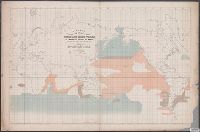
[Maury map collection ; ser. F5] and Sperm and right whale
Description:
"By authority of Commo: Charles Morris U.S.N., Chief of Bureau of Ordnance and Hydrography, 1853."
Publisher:
United States Hydrographical Office,
Subject (Name):
Endicott & Co. (New York, N.Y.), Maury, Matthew Fontaine, 1806-1873. Wind and current charts, Morris, Charles, 1784-1856, United States. Bureau of Ordnance and Hydrography, United States. Hydrographic Office, and Wyman, R. H. (Robert Harris), 1822-1882
Subject (Topic):
Right whales--Maps, Sperm whale--Maps, Whales--Behavior--Maps, and Whaling--Maps
Found in:
Beinecke Rare Book and Manuscript Library > A chart showing the favorite resort of the sperm and right whale [cartographic material] / by M.F. Maury L.L.D. Lieut. U.S. Navy ; constructed from Maury's whale chart of the world by Robt. H. Wyman Lieut. U.S.N.
Creator:
Published / Created:
1909
Call Number:
BrSides Double Folio 2018 95
Image Count:
1
Resource Type:
Maps, Atlases & Globes
Alternative Title:
G.S.G.S. ; No. 1849 and GSGS (Series) ; No. 1849
Description:
Backed with linen.
Publisher:
War Office,
Subject (Topic):
Cables, Submarine--Maps., Telegraph, Telegraph--Maps., and World maps
Found in:
Beinecke Rare Book and Manuscript Library > Cable map of the world [cartographic material].
Creator:
Published / Created:
[1900]
Call Number:
BrSides Double Folio 2019 2
Image Count:
1
Resource Type:
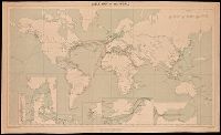
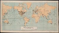
Maps, Atlases & Globes
Description:
Also shows area and population notes, railroads in colonies, submarine cables, steamship lines with distances, and canals.
Publisher:
Norris Peters Co., Photo-Litho
Subject (Name):
Norris Peters Co
Subject (Topic):
Colonies--Maps.
Found in:
Beinecke Rare Book and Manuscript Library > Colonial systems of the world / U.S. Treasury Department, Bureau of Statistics ; O.P. Austin, chief of Bureau.
Creator:
Published / Created:
[1898]
Call Number:
BrSides Folio 2019 4
Image Count:
1
Resource Type:
Maps, Atlases & Globes
Description:
Includes list of countries with colonies, number, size and population of colonies.
Publisher:
U.S. Treasury Dept., Bureau of Statistics,
Subject (Topic):
Colonies, Colonies--Maps, Protectorates, and Protectorates--Maps
Found in:
Beinecke Rare Book and Manuscript Library > Colonies, dependencies and protectorates of the world [cartographic material] : showing area and population of the colonies, dependencies, protectorates and spheres of influence.
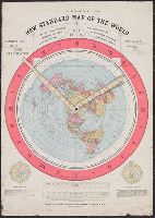
Published / Created:
1892.
Call Number:
11 1892
Image Count:
2
Resource Type:
cartographic image
Abstract:
Map of the globe stretched and flattened into a circular plane (azimuthal projection), with two movable arms to calculate time in places around the world
Alternative Title:
New standard map of the world
Description:
Map of the globe stretched and flattened into a circular plane.
Publisher:
Buffalo Electrotype and Engraving Co.
Subject (Topic):
Map projections and World maps
Found in:
Beinecke Rare Book and Manuscript Library > Gleason's new standard map of the world : on the projection of J.S. Christopher, Modern College, Blackheath, England ; scientifically and practically correct ; as "it is."
Creator:
Published / Created:
[1905?]
Call Number:
BrSides Double Folio 2018 91
Image Count:
1
Resource Type:
Maps, Atlases & Globes
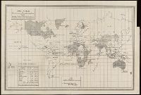
Description:
Manuscript note in right margin: Transportation routes.
Publisher:
Department of Commerce and Labor, Bureau of Statistics,
Subject (Name):
Norris Peters Co
Subject (Topic):
Transportation--Maps and World maps
Found in:
Beinecke Rare Book and Manuscript Library > Principal transportation routes of the world.
Branch:v1.68.6 ,Deployed:2025-07-02T08:09:28-04:00