Search
You Searched For
Search Results
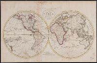
- Published / Created:
- [1795?]
- Call Number:
- 11 1795A
- Container / Volume:
- BRBL_00006
- Image Count:
- 1
- Resource Type:
- Maps, Atlases & Globes
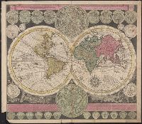
- Found in:
- Beinecke Rare Book and Manuscript Library > A Chart of the World, According to Mercator's Projection, showing the latest discoveries of Capt. Cook.
- Published / Created:
- [1795?]
- Call Number:
- 11 1795A
- Container / Volume:
- BRBL_00006
- Image Count:
- 1
- Resource Type:
- Maps, Atlases & Globes
- Found in:
- Beinecke Rare Book and Manuscript Library > A Chart of the World, According to Mercator's Projection, showing the latest discoveries of Capt. Cook.
- Published / Created:
- 1795
- Call Number:
- 11 1795
- Container / Volume:
- BRBL_00006
- Image Count:
- 1
- Resource Type:
- Maps, Atlases & Globes
- Found in:
- Beinecke Rare Book and Manuscript Library > A Map of the World from the best Authorities.
- Creator:
- Adam and Charles Black (Firm)
Aikman, George, engraver
Barlow, Peter, 1776-1862
- Published / Created:
- 1854]
- Call Number:
- 11 1854
- Container / Volume:
- BRBL_00009
- Image Count:
- 1
- Resource Type:
- Maps, Atlases & Globes
- Found in:
- Beinecke Rare Book and Manuscript Library > A chart of magnetic curves of equal variation / by Peter Barlow.
- Creator:
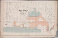
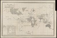
- Maury, Matthew Fontaine, 1806-1873
- Published / Created:
- 1853
- Call Number:
- 11DB 1851A-2
- Container / Volume:
- BRBL_00774
- Image Count:
- 1
- Resource Type:
- Maps, Atlases & Globes
- Found in:
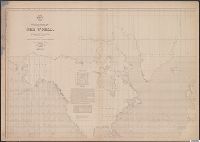
- Beinecke Rare Book and Manuscript Library > A chart showing the favorite resort of the sperm and right whale [cartographic material] / by M.F. Maury L.L.D. Lieut. U.S. Navy ; constructed from Maury's whale chart of the world by Robt. H. Wyman Lieut. U.S.N.
- Creator:
- Great Britain. War Office. General Staff. Geographical Section
- Published / Created:
- 1909
- Call Number:
- BrSides Double Folio 2018 95
- Image Count:
- 1
- Resource Type:
- Maps, Atlases & Globes
- Found in:
- Beinecke Rare Book and Manuscript Library > Cable map of the world [cartographic material].
- Creator:
- International Telecommunication Union. Bureau
- Published / Created:
- 1896
- Call Number:
- BrSides Folio 2018 130
- Image Count:
- 1
- Resource Type:
- Maps, Atlases & Globes
- Found in:
- Beinecke Rare Book and Manuscript Library > Carte générale des grandes communications télégraphiques du monde / dressée d'après des documents officiels par le Bureau International des Administrations Télégraphiques ; dessinée et gravée par C. v. Hoven.
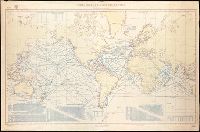
- Creator:
- United States. Department of the Treasury. Bureau of Statistics
- Published / Created:
- [1900]
- Call Number:
- BrSides Double Folio 2019 2
- Image Count:
- 1
- Resource Type:
- Maps, Atlases & Globes
- Found in:
- Beinecke Rare Book and Manuscript Library > Colonial systems of the world / U.S. Treasury Department, Bureau of Statistics ; O.P. Austin, chief of Bureau.
- Creator:
- United States. Bureau of Statistics
- Published / Created:
- [1898]
- Call Number:
- BrSides Folio 2019 4
- Image Count:
- 1
- Resource Type:
- Maps, Atlases & Globes
- Found in:
- Beinecke Rare Book and Manuscript Library > Colonies, dependencies and protectorates of the world [cartographic material] : showing area and population of the colonies, dependencies, protectorates and spheres of influence.
- Creator:
- Bougainville, Louis-Antoine de, comte, 1729-1811
- Published / Created:
- [1771]
- Call Number:
- BrSides Folio 2019 83
- Collection Title:
- Voyage autour du monde par la frégate du Roi la Boudeuse, et la flûte l'Etoile, en 1766, 1767, 1768
- Image Count:
- 1
- Resource Type:
- Maps, Atlases & Globes
- Found in:
- Beinecke Rare Book and Manuscript Library > Dévelopement de la route des Vaisseaux du Roy la Boudeuse et l'Etiole autour du monde / [by Louis Antoine de Bougainville].
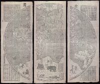
- Creator:
- Verbiest, Ferdinand, 1623-1688.
- Published / Created:
- [Xianfeng geng shen [1860]] and [咸豐庚申[1860]]
- Call Number:
- 11 1860
- Image Count:
- 8
- Resource Type:
- Maps, Atlases & Globes
- Found in:
- Beinecke Rare Book and Manuscript Library > Kun yu quan tu [cartographic material] : [er juan] / [Verbiest, Ferdinand].
- Creator:
- Plancius, Petrus, 1552-1622
- Published / Created:
- [1594]
- Call Number:
- 11 1594
- Container / Volume:
- BRBL_00002
- Image Count:
- 1
- Resource Type:
- Maps, Atlases & Globes
- Found in:
- Beinecke Rare Book and Manuscript Library > Orbis terrarum typus de integro multis in locis emendatus [cartographic material] / auctore Petro Plancio, 1594 ; Ioannes à Duetecum iunior fecit.
- Creator:
- Zuerner, Adam Friedrich, 1680-1742
- Published / Created:
- [1709?]
- Call Number:
- 11 1709
- Container / Volume:
- BRBL_00680
- Image Count:
- 1
- Resource Type:
- Maps, Atlases & Globes
- Found in:
- Beinecke Rare Book and Manuscript Library > Planisphaerium terrestre cum utroque coelesti hemisphaerio, sive diversa orbis terraquei = Vlakke aard-kloot met het beide hemelsch half-rond, of de onder scheidene verbeelding van de land-water-waereld / opera et studio A.F. Zürneri.
- Creator:
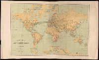
- United States. Department of Commerce and Labor. Bureau of Statistics
- Published / Created:
- [1905?]
- Call Number:
- BrSides Double Folio 2018 91
- Image Count:
- 1
- Resource Type:
- Maps, Atlases & Globes
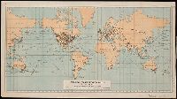
- Found in:
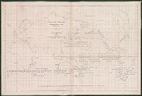
- Beinecke Rare Book and Manuscript Library > Principal transportation routes of the world.
- Published / Created:
- [1895]
- Call Number:
- BrSides Double Folio 2019 1
- Image Count:
- 1
- Resource Type:
- Maps, Atlases & Globes
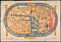
- Found in:
- Beinecke Rare Book and Manuscript Library > S. Beati Liebanensis mappam mundi ad exemplar ecclesiae Snacto Severi, quod nunc Parisiis asservatur, primum integram edidit Conradus Miller.
- Published / Created:
- [1898]
- Call Number:
- BrSides Folio 2019 2
- Image Count:
- 1
- Resource Type:
- Maps, Atlases & Globes
- Found in:
- Beinecke Rare Book and Manuscript Library > Sphaera jvlii honorii.
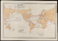
- Creator:
- United States. Department of the Treasury. Bureau of Statistics
- Published / Created:
- [1899]
- Call Number:
- BrSides Folio 2019 64
- Image Count:
- 1
- Resource Type:
- Maps, Atlases & Globes
- Found in:
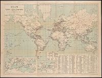
- Beinecke Rare Book and Manuscript Library > Submarine and land telegraph systems of the world [cartographic material].
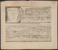
- Published / Created:
- 1652?]
- Call Number:
- 11 1652
- Container / Volume:
- BRBL_00732
- Image Count:
- 4
- Resource Type:
- Maps, Atlases & Globes
- Found in:
- Beinecke Rare Book and Manuscript Library > Tabvla itineraria ex illustri Peutingerorum, bibliotheca quae Augustae Vindelicorum / beneficio Marci Velseri, septem-viri Augustani in lucem edita.
- Creator:
- Horn, Georg, 1620-1670
Jansson, Jan, 1588-1664. Accuratissima Orbis antiqui delineatio... [1652?]
Jansson, Jan, 1588-1664. Novus Atlas
Peutinger, Konrad, 1465-1546 or 7
Welser, Marcus, 1558-1614
- Published / Created:
- 1652?]
- Call Number:
- 314 1654
- Container / Volume:
- BRBL_00038
- Image Count:
- 4
- Resource Type:
- Maps, Atlases & Globes
- Found in:
- Beinecke Rare Book and Manuscript Library > Tabvla itineraria ex illustri Peutingerorum, bibliotheca quae Augustae Vindelicorum / beneficio Marci Velseri, septem-viri Augustani in lucem edita.
- Creator:
- Harper & Brothers, cartographer, publisher
- Call Number:
- 11 1840C
- Image Count:
- 1
- Resource Type:
- Maps, Atlases & Globes
- Found in:
- Beinecke Rare Book and Manuscript Library > The world on Mercator's projection : intermediate series / engraved by Charles Copley.
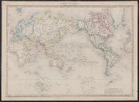
- Creator:
- Wyld, James, 1812-1887, creator
- Published / Created:
- 1852
- Call Number:
- 11 1852A
- Container / Volume:
- BRBL_00009
- Image Count:
- 1
- Resource Type:
- Maps, Atlases & Globes
- Found in:
- Beinecke Rare Book and Manuscript Library > The world, on Mercator's projection.
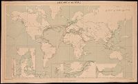
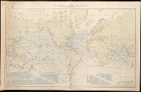
- Creator:
- United States. Hydrographic Office
- Published / Created:
- Sep., 1914 [that is, 1916]
- Call Number:
- BrSides Elephant Folio 2018 22
- Image Count:
- 1
- Resource Type:
- Maps, Atlases & Globes
- Found in:
- Beinecke Rare Book and Manuscript Library > Tracks for full powered steam vessels with the shortest navigable distances in nautical miles from anchorage to anchorage, New York distances are measures to and from the Battery achorage.
- Creator:
- United States. Hydrographic Office
- Published / Created:
- Sep., 1914 [that is, 1918]
- Call Number:
- BrSides Elephant Folio 2018 21
- Image Count:
- 1
- Resource Type:
- Maps, Atlases & Globes
- Found in:
- Beinecke Rare Book and Manuscript Library > Tracks for full powered steam vessels with the shortest navigable distances in nautical miles from anchorage to anchorage, New York distances are measures to and from the Battery achorage.
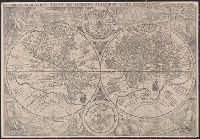
- Creator:
- Münster, Sebastian, 1489-1552
- Published / Created:
- [1532]
- Call Number:
- 11 1509A
- Image Count:
- 1
- Resource Type:
- Maps, Atlases & Globes
- Found in:
- Beinecke Rare Book and Manuscript Library > Typus cosmographicus uniuersalis.
- Creator:
- Gea verlag
- Published / Created:
- [1911?]
- Call Number:
- BrSides Double Folio 2018 94
- Image Count:
- 1
- Resource Type:
- Maps, Atlases & Globes
- Found in:
- Beinecke Rare Book and Manuscript Library > Weltkarte der Funken- u. Kabel-Telegraphie.
- Creator:
- Maury, Matthew Fontaine, 1806-1873
- Published / Created:
- 1851
- Call Number:
- 11DB 1851A-1
- Container / Volume:
- BRBL_00774
- Image Count:
- 1
- Resource Type:
- Maps, Atlases & Globes
- Found in:
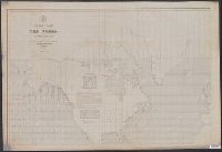
- Beinecke Rare Book and Manuscript Library > Whale chart [cartographic material] : preliminary sketch / by M.F. Maury, A.M. Lieut., U.S. Navy ; constructed by Lts. Leigh. Herndon & Fleming & Pd. Midn. Jackson.
- Creator:
- Maury, Matthew Fontaine, 1806-1873
- Published / Created:
- 1852
- Call Number:
- 11cfk 1850F
- Container / Volume:
- BRBL_00774
- Image Count:
- 4
- Resource Type:
- Maps, Atlases & Globes
- Found in:
- Beinecke Rare Book and Manuscript Library > Whale chart of the world [cartographic material] / by M.F. Maury, L.L.D. Lieut. U.S. Navy, superin'dt. of U.S.N. Observatory ; compiled from materials in the Bureau of Ordnance and Hydrography by P.M. A.C. Jackson.
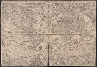
- Creator:
- Mercator, Gerhard, 1512-1594, cartographer
- Published / Created:
- [19--]
- Call Number:
- 11 1538B
- Image Count:
- 1
- Resource Type:
- Maps, Atlases & Globes
- Found in:
- Beinecke Rare Book and Manuscript Library > [Mapamundi of 1538] [cartographic material].