Search
You Searched For
Search Results
- Creator:
- Abreu de Galindo, Juan de.
- Published / Created:
- MDCCLXIV [1764]
- Call Number:
- BrSides 2019 4
- Image Count:
- 9
- Resource Type:
- Maps, Atlases & Globes
- Found in:
- Beinecke Rare Book and Manuscript Library > The history of the discovery and conquest of the Canary Islands : translated from a Spanish manuscript lately found in the island of Palma : with an enquiry into the origin of the ancient inhabitants : to which is added, A description of the Canary Island
- Creator:
- Ringgold, Cadwalader, 1802-1867
- Published / Created:
- [1851?]
- Call Number:
- 844cea Sa52 1850A
- Container / Volume:
- BRBL_00614
- Image Count:
- 1
- Resource Type:
- Maps, Atlases & Globes
- Found in:
- Beinecke Rare Book and Manuscript Library > Chart of the Farallones and entrance to the bay of San Francisco : California / by Cadwalader Ringgold, Commander, U.S. Navy ; assisted by Simon F. Blunt, Lieut., U.S. Navy, 1850.
- Creator:
- Ringgold, Cadwalader, 1802-1867
- Published / Created:
- [1851?]
- Call Number:
- 844cea Sa52 1850B
- Container / Volume:
- BRBL_00614
- Image Count:
- 1
- Resource Type:
- Maps, Atlases & Globes
- Found in:
- Beinecke Rare Book and Manuscript Library > Chart of the bay of San Pablo, Straits of Carquines, and part of the bay of San Francisco : California / by Cadwalader Ringgold, Commander, U.S. Navy ; assisted by Simon F. Blunt, Lieut., U.S.N., 1850.
- Creator:
- Ringgold, Cadwalader, 1802-1867
- Published / Created:
- [1851?]
- Call Number:
- 844cea Sa52 1850A
- Container / Volume:
- BRBL_00614
- Image Count:
- 1
- Resource Type:
- Maps, Atlases & Globes
- Found in:
- Beinecke Rare Book and Manuscript Library > Chart of the Farallones and entrance to the bay of San Francisco : California / by Cadwalader Ringgold, Commander, U.S. Navy ; assisted by Simon F. Blunt, Lieut., U.S. Navy, 1850.
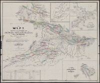
- Creator:
- Hendges, M
- Published / Created:
- 1904
- Call Number:
- 70gme 1904
- Container / Volume:
- BRBL_00359
- Image Count:
- 1
- Resource Type:
- Maps, Atlases & Globes
- Found in:
- Beinecke Rare Book and Manuscript Library > Intercontinental railway map : prepared under the direction of the permanent Pan American Railway Committee authorized by the Second International Conference of American States / M. Hendges.
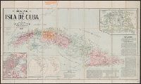
- Creator:
- Smith, John L., 1846-1921
- Published / Created:
- 1897
- Call Number:
- 855 1897B
- Container / Volume:
- BRBL_00641
- Image Count:
- 1
- Resource Type:
- Maps, Atlases & Globes
- Found in:
- Beinecke Rare Book and Manuscript Library > Mapa de la isla de Cuba.
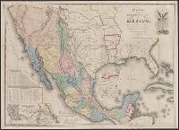
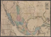
- Creator:
- Disturnell, John, 1801-1877
- Published / Created:
- 1847
- Call Number:
- 88 1847G
- Container / Volume:
- BRBL_00645
- Image Count:
- 1
- Resource Type:
- Maps, Atlases & Globes
- Found in:
- Beinecke Rare Book and Manuscript Library > Mapa de los Estados Unidos de Méjico / segun lo organizado y definido por las varias actas del Congreso de dicha República y construido por las mejores autoridades.
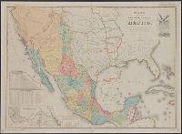
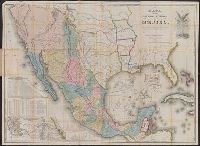
- Creator:
- Disturnell, John, 1801-1877
- Published / Created:
- 1935
- Call Number:
- 88 1847H
- Container / Volume:
- BRBL_00645
- Image Count:
- 1
- Resource Type:
- Maps, Atlases & Globes
- Found in:
- Beinecke Rare Book and Manuscript Library > Mapa de los Estados Unidos de Méjico / segun lo organizado y definido por las varias actas del Congreso de dicha República y construido por las mejores autoridades ; lo publican, J. Disturnell.
- Published / Created:
- 1845]
- Call Number:
- 88 1845D
- Container / Volume:
- BRBL_00645
- Image Count:
- 1
- Resource Type:
- Maps, Atlases & Globes
- Found in:
- Beinecke Rare Book and Manuscript Library > Carta geografica general de la republica Mexicana / formada el ano de 1845, con los datos que reunio la seccion de Geografia del Ministerio de la Guerra, por el General de Brigada Pedro Garcia Conde.
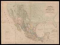
- Creator:
- Disturnell, John, 1801-1877
- Published / Created:
- 1846
- Call Number:
- 88 1846G
- Container / Volume:
- BRBL_00645
- Image Count:
- 1
- Resource Type:
- Maps, Atlases & Globes
- Found in:
- Beinecke Rare Book and Manuscript Library > Mapa de los Estados Unidos de Méjico / según lo organizado y definido por las varias actas del Congreso de dicha República y construido por las mejores autoridades ; lo publican J. Disturnell.
- Creator:
- Disturnell, John, 1801-1877
- Published / Created:
- 1847
- Call Number:
- 88 1847N
- Container / Volume:
- BRBL_00645
- Image Count:
- 1
- Resource Type:
- Maps, Atlases & Globes
- Found in:
- Beinecke Rare Book and Manuscript Library > Mapa de los Estados Unidos de Méjico / segun lo organizado y definido por las varias actas del Congreso de dicha Républica y construido por las mejores autoridades.
- Creator:
- E. & G.W. Blunt (Firm)
- Published / Created:
- 1849
- Call Number:
- 88cea 1849
- Container / Volume:
- BRBL_00648
- Image Count:
- 1
- Resource Type:
- Maps, Atlases & Globes
- Found in:
- Beinecke Rare Book and Manuscript Library > West coast of North America from the Gulf of Dulce to San Francisco.
- Creator:
- Cox, Gustavo
- Published / Created:
- 1865
- Call Number:
- 88192gfc 1865
- Container / Volume:
- BRBL_00653
- Image Count:
- 1
- Resource Type:
- Maps, Atlases & Globes
- Found in:
- Beinecke Rare Book and Manuscript Library > Mapa de los distritos minerales de San Antonio, El Triunfo, Las Cacachilas y Isla de Carmen : Baja California, República de México / recopilado y delineado por Don Gustavo Cox, ingeniero de minas.
- Creator:
- Ferrer, Fermin
- Published / Created:
- 1855
- Call Number:
- 895 1855
- Container / Volume:
- BRBL_00659
- Image Count:
- 1
- Resource Type:
- Maps, Atlases & Globes
- Found in:
- Beinecke Rare Book and Manuscript Library > Geographical map of the Republic of Nicaragua : with three plans and views / by Fermin Ferrer, Governor of the Western Dept.
- Creator:
- Trudeau, Charles Laveau, ca. 1750-1816
- Published / Created:
- 1808]
- Call Number:
- BrSide4o Zc22 808thha
- Image Count:
- 4
- Resource Type:
- Maps, Atlases & Globes
- Found in:
- Beinecke Rare Book and Manuscript Library > [Plans of New Orleans to accompany J.B.S. Thierry's Examen des droits des Etats Unis et des pretentions de Mr. Edouard Livingston sur la batture de Mr. Edouard Livingston sur la batture en face du faubourg Ste. Marie].
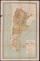
- Creator:
- Martínez, Alberto B
- Published / Created:
- 1910
- Call Number:
- 94 1910B
- Container / Volume:
- BRBL_00675
- Image Count:
- 2
- Resource Type:
- Maps, Atlases & Globes
- Found in:
- Beinecke Rare Book and Manuscript Library > Mapa general de la República Argentina [cartographic material] / Alberto B. Martinez.
- Creator:
- Baluarte, Rafael E
- Published / Created:
- 1903
- Call Number:
- 97 1903
- Container / Volume:
- BRBL_00677
- Image Count:
- 2
- Resource Type:
- Maps, Atlases & Globes
- Found in:
- Beinecke Rare Book and Manuscript Library > Map of Peru / published by D.E. Larrabure y Unánue, Minister of Foreign Affairs.
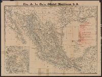
- Creator:
- Rand McNally and Company
- Published / Created:
- c1904.
- Call Number:
- 88gme 1904
- Container / Volume:
- BRBL_00649
- Image Count:
- 2
- Resource Type:
- Maps, Atlases & Globes
- Found in:
- Beinecke Rare Book and Manuscript Library > Mexico.
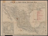
- Creator:
- Rand McNally and Company
- Published / Created:
- c1904.
- Call Number:
- 88gme 1904
- Container / Volume:
- BRBL_00649
- Image Count:
- 2
- Resource Type:
- Maps, Atlases & Globes
- Found in:
- Beinecke Rare Book and Manuscript Library > Mexico.