Search
You Searched For
Search Results
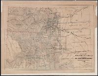
- Creator:
- Hollister, Ovando James, 1834-1892
- Published / Created:
- 1866
- Call Number:
- 834 1866
- Container / Volume:
- BRBL_00587
- Image Count:
- 1
- Resource Type:
- Maps, Atlases & Globes
- Found in:
- Beinecke Rare Book and Manuscript Library > Map of Colorado Territory to accompany Hollisters "Mines of Colorado" corrected from the Public Surveys of 1866.
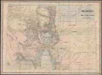
- Creator:
- Ebert, Frederick J
- Published / Created:
- 1865, c1862
- Call Number:
- 834 1865
- Container / Volume:
- BRBL_00587
- Image Count:
- 1
- Resource Type:
- Maps, Atlases & Globes
- Found in:
- Beinecke Rare Book and Manuscript Library > Map of Colorado territory, shewing the system of parks / drawn by Frederick J. Ebert.
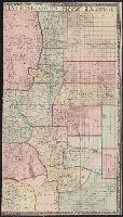
- Creator:
- Bonsall, J. H
- Published / Created:
- 1872
- Call Number:
- 834 1872
- Container / Volume:
- BRBL_00587
- Image Count:
- 2
- Resource Type:
- Maps, Atlases & Globes
- Found in:
- Beinecke Rare Book and Manuscript Library > Map of Colorado, with plans of its principal towns / compiled from official authorities by J.H. Bonsall and E.H. Kellogg.
- Creator:
- De Werthern, H
- Published / Created:
- 1869]
- Call Number:
- 836 1869
- Container / Volume:
- BRBL_00592
- Image Count:
- 1
- Resource Type:
- Maps, Atlases & Globes
- Found in:
- Beinecke Rare Book and Manuscript Library > Map of Utah and Colorado / prepared by order of Lieut. Genl. W.T. Sherman ; drawn by H. De Werthern.
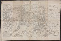
- Creator:
- Pratt, John J., b. 1833
- Published / Created:
- 1862
- Call Number:
- 834gfc C33 1862
- Container / Volume:
- BRBL_00590
- Image Count:
- 4
- Resource Type:
- Maps, Atlases & Globes
- Found in:
- Beinecke Rare Book and Manuscript Library > Map of the gold regions in the vicinity of Central City, Gilpin County, Colorado Territory / from actual survey by John J. Pratt and Bela S. Buell, civil engineers and surveyors.
- Creator:
- Nell, Louis
- Published / Created:
- 1903
- Call Number:
- 834 1903
- Container / Volume:
- BRBL_00588
- Image Count:
- 1
- Resource Type:
- Maps, Atlases & Globes
- Found in:
- Beinecke Rare Book and Manuscript Library > Nell's topographical map of the state of Colorado.
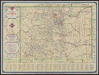
- Creator:
- H.M. Gousha Company
- Published / Created:
- [1935].
- Call Number:
- 834gmb 1935
- Container / Volume:
- BRBL_00591
- Image Count:
- 2
- Resource Type:
- Maps, Atlases & Globes
- Found in:
- Beinecke Rare Book and Manuscript Library > Official road map, Colorado / Conoco Travel Bureau.
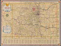
- Creator:
- H.M. Gousha Company
- Published / Created:
- [1937]
- Call Number:
- 834gmb 1937
- Container / Volume:
- BRBL_00591
- Image Count:
- 2
- Resource Type:
- Maps, Atlases & Globes
- Found in:
- Beinecke Rare Book and Manuscript Library > Official road map, Colorado / [prepared for] Shell.
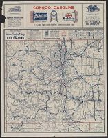
- Creator:
- Rand McNally and Company
- Published / Created:
- c1924.
- Call Number:
- 834gmb 1924
- Container / Volume:
- BRBL_00591
- Image Count:
- 2
- Resource Type:
- Maps, Atlases & Globes
- Found in:
- Beinecke Rare Book and Manuscript Library > Rand McNally official 1924 : auto trails map of Colorado.
- Creator:
- Rand McNally and Company
- Published / Created:
- 1891
- Call Number:
- 834 1891
- Container / Volume:
- BRBL_00587
- Image Count:
- 1
- Resource Type:
- Maps, Atlases & Globes
- Found in:
- Beinecke Rare Book and Manuscript Library > Rand, McNally & Co.'s Colorado.