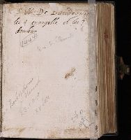
Manuscript on paper (unidentified watermarks in gutter; upper margin, trimmed) of a Ritual, possibly written for a nunnery.
Description:
Binding: Sixteenth century. Original sewing on three double, tawed supports laced into the wooden boards. The spine is heavily rounded, with the sewing supports well defined by blind-tooled lines. Covered in dark brown calf with a panel of the Annunciation, in a border of birds, animals and flowers blind-stamped on each board inside outer frames of lines. There is a brass catch on the upper board and a long, thin brass clasp on a leather strap attached to the lower with a brass plate. The leather is slightly torn at the head of the spine but otherwise the book is in fine condition, with no trace of sophistication. Front and back pastedowns from a 15th-century Latin liturgical manuscript., Calligraphic initials, 5- to 3-line, in green or red with red or grey flourishes, often extending the length of the written area. Initials, 3- to 1-line, underlining, strokes on 1-line initials, and headings in red., and Script: Written by three people in what Lieftinck calls Littera brevitura. Scribe 1, ff. 1r-87v and 98r-153v, writes in a large and rather careless hand; 2, ff. 90r-97v, in a small even hand; 3, ff. 154r-272v, in a large uneven hand.
Subject (Name):
Catholic Church--Liturgy
Subject (Topic):
Manuscripts, Medieval--Connecticut--New Haven, Medieval and Renaissance Manuscripts in Beinecke Library, Monastic and religious life--Early works to 1800, and Rituals (Liturgical books)
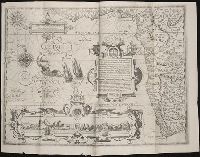
Descriptio ac delineatio geographica detectionis freti, sive, transitus ad occasum supra terras
Image Count:
1
Abstract:
Map depicts the Coat of Arms of the United Kingdom (era of the Union of the Crowns), reigning between the years 1603-1707.
Alternative Title:
Tabula nautica, qua repraesentantur orae maritimae, meatus, ac freta, noviter a H. Hudsono Anglo ad Caurum supra Novam Franciam
Description:
Bound in after p. [2]., In pencil on recto: 170., Map cut and folded irregularly., Map has multiple small stains on both the recto and verso., and Scale [ca. 1:9,000,000].
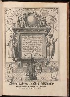
Nauigatio ac itinerarium Iohannis Hugonis Linscotani in Orientalem siue Lusitanorum Indiam
Image Count:
1
Description:
[Scale ca. 1:13,000,000]., Bound in following title page of "Descriptio totius Guineae tractus ...", In ink on top left panel of left verso: 3., and Map has several small tears now repaired on verso.
Subject (Geographic):
Africa, West --Maps --Early works to 1800
Subject (Name):
Claesz, Cornelis, ca. 1546-1609, publisher, Elzevier, Gillis, bookseller, and Hendricksz, Aelbrecht, fl. 1573-1605, printer
Subject (Topic):
Voyages and travels --Early works to 1800
Collection Created:
Hagae-Comitis : Ex officina Alberti Henrici, impensis authoris & Cornelii Nicolai, prostantque apud Aegidium Elseuirum, anno 1599