Distributed as a supplement to De Stijl and also sold separately., In Dutch, English, French or German., and Issues for 1922 published without numbering but called yellow, blue, red and constitute no. 1-3; issue for 1923 numbered 4/5 and also called white.
Distributed as a supplement to De Stijl and also sold separately., In Dutch, English, French or German., and Issues for 1922 published without numbering but called yellow, blue, red and constitute no. 1-3; issue for 1923 numbered 4/5 and also called white.
Distributed as a supplement to De Stijl and also sold separately., In Dutch, English, French or German., and Issues for 1922 published without numbering but called yellow, blue, red and constitute no. 1-3; issue for 1923 numbered 4/5 and also called white.
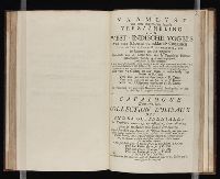
... Iohn Hvighen van Linschoten. his Discours of Voyages into ye Easte & West Indies. Deuided into
Image Count:
1
Abstract:
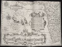
Engraved map depicts part of the south and west edge of Africa and also the islands of Ascension and Saint Helena within a special border.
Description:
[Scale ca. 1:13,000,000]., Bound in following title page of the second book., Map has been repaired with tape on verso., Map has black line on verso in center., Map has mirror image of brown marks on verso on bottom folded panels., and Map properly belongs to the Dutch edition of 1596.
Subject (Geographic):
Africa --Maps --Early works to 1800, Africa, West --Description and travel --Early works to 1800, Africa, West --Maps --Early works to 1800, Ascension Island (Atlantic Ocean) --Description and travel, and Saint Helena --Description and travel
Subject (Topic):
Voyages and travels --Early works to 1800
Collection Created:
Printed at London by Iohn Wolfe Printer to ye Honorable Cittie of London [1598]
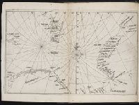
Descriptio ac delineatio geographica detectionis freti, sive, transitus ad occasum supra terras
Image Count:
1
Description:
Bound in after p. [40]., Map has water stain on recto in upper right corner., Printed on recto in lower right corner: F., and Scale [ca. 1:10,000,000].
Subject (Geographic):
Barents Sea --Maps --Early works to 1800. and Norwegian Sea --Maps --Early works to 1800
Collection Created:
Amsterodami Ex officina Hesse lij Gerardi. Anno 1613