Search
You Searched For
Search Results
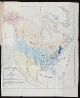
- Call Number:
- 1974 +231
- Collection Title:
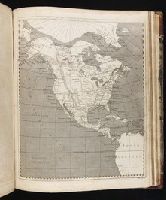
- A new and elegant general atlas, comprising all the new discoveries, to the present time
- Image Count:
- 1
- Subject (Geographic):
- North America--Maps
- Found in:
- Beinecke Rare Book and Manuscript Library > [Map of North America]
- Creator:
- Tanner, Henry Schenck, 1786-1858
- Published / Created:
- 1822
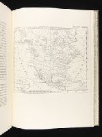
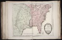
- Call Number:
- 2003 Folio 81
- Collection Title:
- The New American Atlas ...
- Container / Volume:
- No. IV [4]
- Image Count:
- 1
- Subject (Geographic):
- North America--Maps
- Found in:
- Beinecke Rare Book and Manuscript Library > A Map of North America, Constructed According to the Latest Information by H. S. Tanner
- Creator:
- Bowles, Carington, 1724-1793
Bowles, John, 1701-1779
Delarochette, L. (Louis), 1731-1802, creator
Palairet, Jean, 1697-1774
- Published / Created:
- 1765
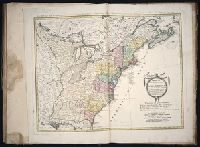
- Call Number:
- 2003 Folio 85
- Image Count:
- 1
- Description:
- LC Maps of North America, 1750-1789,
- Subject (Geographic):
- North America -- Maps -- Early works to
- Found in:
- Beinecke Rare Book and Manuscript Library > A map of North America
- Call Number:
- 1976 1233
- Collection Title:
- Forty-two new maps of Asia, Africa, and America ... : all engrav’d, according to the latest
- Image Count:
- 1
- Subject (Geographic):
- North America --Maps --Early works to
- Found in:
- Beinecke Rare Book and Manuscript Library > A new map of North America according to the newest observations
- Creator:
- Morse, Jedidiah, 1761-1826
- Published / Created:
- 1797
- Call Number:
- GA405 +W44 (LC)
- Collection Title:
- Mapping the transmississippi West, 1540-1861
- Image Count:
- 1
- Subject (Geographic):
- North America--Maps
- Found in:
- Beinecke Rare Book and Manuscript Library > A new map of North America shewing all the new discoveries [facsimile]
- Creator:
- Bowen, Emanuel, d. 1767
Gibson, J. (John)
Overton, Henry, fl. 1706-1764
Sayer, Robert, 1725-1794
- Published / Created:
- [between 1755 and 1775?]
- Call Number:
- 2003 Folio 85
- Image Count:
- 1
- Subject (Geographic):
- North America -- Maps -- Early works to
- Found in:
- Beinecke Rare Book and Manuscript Library > An accurate map of North America: describing and distinguishing the British, Spanish and French dominions on this great continent; exhibiting the present seat of war, and the French encroachments. Also all the West India Islands belonging to, and possesse
- Creator:
- Gussefeld, F. L. (Franz Ludwig), 1744-1807
Homann Erben (Firm)
Schmidt, I. M.
- Published / Created:
- ao. 1784
- Call Number:
- 1983 Folio 23
- Collection Title:
- [Atlas factice of 50 maps, primarily by Johann Baptist Homann and/or issued by the Homann Erben
- Image Count:
- 1
- Subject (Geographic):
- North America --Maps --Early works to
- Found in:
- Beinecke Rare Book and Manuscript Library > Charte ueber die XIII vereinigte Staaten von Nord-Amerika / [cartographic material] / entworfen durch F.L. Guessefeld ; und herausgegeben von den Homaennischen Erben
- Call Number:
- 1974 +231
- Collection Title:
- A new and elegant general atlas, comprising all the new discoveries, to the present time
- Image Count:
- 1
- Subject (Geographic):
- North America--Maps
- Found in:
- Beinecke Rare Book and Manuscript Library > [Map of the United States of America]
- Creator:
- Des Barres, Joseph F. W. (Joseph Frederick Wallet), 1722-1824
- Published / Created:
- 1775?-1781?]
- Call Number:
- 1983 Folio 25
- Image Count:
- 3
- Resource Type:
- Maps, Atlases & Globes
- Subject (Geographic):
- North America--Maps
- Found in:
- Beinecke Rare Book and Manuscript Library > [The Atlantic Neptune : published for the use of the Royal Navy Great Britain / by Joseph F.W. Des Barres, esq.].
- Published / Created:
- ca. 1783
- Call Number:
- GA405 +W44 (LC)
- Collection Title:
- Mapping the transmississippi West, 1540-1861
- Image Count:
- 1
- Subject (Geographic):
- North America--Maps
- Found in:
- Beinecke Rare Book and Manuscript Library > Mapa de las provincias internas de la America septentrional [facsimile]
- Creator:
- Hooker, William
Jones, Benjamin
- Call Number:
- 1974 +231
- Collection Title:
- A new and elegant general atlas, comprising all the new discoveries, to the present time
- Image Count:
- 1
- Subject (Geographic):
- North America--Maps
- Found in:
- Beinecke Rare Book and Manuscript Library > British possessions in America
- Creator:
- Arrowsmith, Aaron, 1750-1823
Lewis, Samuel, 1753 or 4-1822
- Published / Created:
- 1804
- Call Number:
- GA405 +W44 (LC)
- Collection Title:
- Mapping the transmississippi West, 1540-1861
- Image Count:
- 1
- Subject (Geographic):
- North America--Maps
- Found in:
- Beinecke Rare Book and Manuscript Library > Louisiana
- Creator:
- Collot, Georges-Henri-Victor, 1750-1805
Tardieu, P. F. (Pierre François), 1757-1822
- Published / Created:
- 1796
- Call Number:
- GA405 +W44 (LC)
- Collection Title:
- Mapping the transmississippi West, 1540-1861
- Image Count:
- 1
- Subject (Geographic):
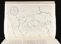
- North America--Maps
- Found in:
- Beinecke Rare Book and Manuscript Library > Map of the Missouri; of the higher parts of the Mississippi; and of the elevated Plain, where the Waters divide, which run, Eastward into the River St. Lawrence; North East into Hudson's Bay; North North West into the Frozen Sea; and South into the Gulf o
- Creator:
- Lewis, Samuel, 1753 or 4-1822
- Call Number:
- 1974 +231
- Collection Title:
- A new and elegant general atlas, comprising all the new discoveries, to the present time
- Image Count:
- 1
- Subject (Geographic):
- North America--Maps
- Found in:
- Beinecke Rare Book and Manuscript Library > [Map of the Louisiana Territory]
- Creator:
- Pike, Zebulon Montgomery, 1779-1813
- Published / Created:
- 1810
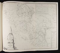
- Call Number:
- GA405 +W44 (LC)
- Collection Title:
- Mapping the transmississippi West, 1540-1861
- Image Count:
- 1
- Subject (Geographic):
- North America--Maps
- Found in:
- Beinecke Rare Book and Manuscript Library > A Chart of the Internal Part of Louisiana, Including all the hitherto unexplored Countries, lying between the River La Platte of the Missouri on the N: and the Red River on the S: the Mississippi East and the Mountains of Mexico West; with a Part of New M
- Published / Created:
- Undated
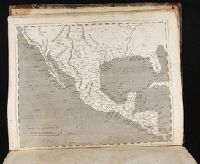
- Call Number:
- Taylor 355
- Collection Title:
- America painted to the life. The true history of the Spaniards proceedings in the conquests of the
- Image Count:
- 1
- Subject (Geographic):
- North America --Maps --Early works to
- Found in:
- Beinecke Rare Book and Manuscript Library > Americae descrip
- Creator:
- Houbloup, L
- Published / Created:
- 1836
- Call Number:
- 1997 876
- Collection Title:
- De la democracia en la America del Norte / por Alejo de Tocqueville, abogado de la real audiencia
- Image Count:
- 1
- Resource Type:
- Books, Journals & Pamphlets
- Subject (Geographic):
- North America --Maps
- Found in:
- Beinecke Rare Book and Manuscript Library > Mapa para la obra intitulada De la Democracia en America por A. de Tocqueville
- Creator:
- Houbloup, L
- Published / Created:
- 1836
- Call Number:
- 1992 230
- Image Count:
- 1
- Resource Type:
- Books, Journals & Pamphlets
- Subject (Geographic):
- North America --Maps
- Found in:
- Beinecke Rare Book and Manuscript Library > Mapa para la obra intitulada De la Democracia en America por A. de Tocqueville
- Creator:
- Bellin, Jacques Nicolas, 1703-1772, creator
France, Depot des cartes et plans de la marine
- Published / Created:
- 1755?
- Call Number:
- 2003 Folio 85
- Image Count:
- 1
- Description:
- LC Maps of North America, 1750-1789,
- Subject (Geographic):
- North America -- Maps -- Early works to
- Found in:
- Beinecke Rare Book and Manuscript Library > Carte de la Louisiane et des pays voisins: dediee a M. Rouille, secretaire d'Etat, ayant le Departement de la marine
- Creator:
- Evans, Lewis, 1700?-1756
Gibson, J. (John), creator
Jefferys, Thomas, d. 1771
- Published / Created:
- 1758
- Call Number:
- 2003 Folio 85
- Image Count:
- 1
- Description:
- LC Maps of North America, 1750-1789,
- Subject (Geographic):
- North America -- Maps -- Early works to
- Found in:
- Beinecke Rare Book and Manuscript Library > A general map of the middle British colonies in America: viz. Virginia, Maryland, Delaware, Pensilvania, New-Jersey, New-York, Connecticut and Rhode-Island : of Aquanishuonigy the country of the confederate Indians comprehending Aquanishuonigy proper, the
- Creator:
- Soulard, Anthoine, 1766-1825
- Published / Created:
- 1795
- Call Number:
- GA405 +W44 (LC)
- Collection Title:
- Mapping the transmississippi West, 1540-1861
- Image Count:
- 1
- Subject (Geographic):
- North America--Maps
- Found in:
- Beinecke Rare Book and Manuscript Library > Ydea Topografica de los Altos del Missisipi y del Missouri ...
- Creator:
- Hooker, William
Jones, Benjamin
- Call Number:
- 1974 +231
- Collection Title:
- A new and elegant general atlas, comprising all the new discoveries, to the present time
- Image Count:
- 1
- Subject (Geographic):
- North America--Maps
- Found in:
- Beinecke Rare Book and Manuscript Library > Spanish dominions in North America
- Creator:
- Marshall, Thomas
- Call Number:
- 1974 +231
- Collection Title:
- A new and elegant general atlas, comprising all the new discoveries, to the present time
- Image Count:
- 1
- Subject (Geographic):
- North America--Maps
- Found in:
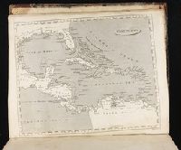
- Beinecke Rare Book and Manuscript Library > West Indies
- Creator:
- Anville, Jean Baptiste Bourguignon d', 1697-1782
Haye, G. de la
- Published / Created:
- Novembre 1755
- Call Number:
- 2003 Folio 85
- Image Count:
- 1
- Subject (Geographic):
- North America -- Maps -- Early works to
- Found in:
- Beinecke Rare Book and Manuscript Library > Canada, Louisiane et terres angloises
- Call Number:
- 1976 1233
- Collection Title:
- Forty-two new maps of Asia, Africa, and America ... : all engrav’d, according to the latest
- Image Count:
- 1
- Subject (Geographic):
- North America --Maps --Early works to
- Found in:
- Beinecke Rare Book and Manuscript Library > A map of America according to ye newest and most exact observations
- Published / Created:
- [1565]
- Call Number:
- 2001 +204 3
- Collection Title:
- Terzo volume delle nauigationi et viaggi / raccolto gia da m. Gio. Battista Ramusio
- Image Count:
- 1
- Subject (Geographic):
- North America--Maps--Early works to
- Found in:
- Beinecke Rare Book and Manuscript Library > Universale della parte del mondo, nuouamente ritrovata
- Published / Created:
- [1565]
- Call Number:
- Taylor 115 3
- Collection Title:
- Terzo volume delle nauigationi et viaggi / raccolto gia da m. Gio. Battista Ramusio
- Container / Volume:
- v. 3
- Image Count:
- 1
- Subject (Geographic):
- North America--Maps--Early works to
- Found in:
- Beinecke Rare Book and Manuscript Library > Universale della parte del mondo, nuouamente ritrovata
- Published / Created:
- 1763 April
- Call Number:
- Z17 299b
- Collection Title:
- Universal museum; or, Gentleman's and ladies polite magazine of history politicks and literature.
- Image Count:
- 1
- Resource Type:
- Books, Journals & Pamphlets
- Subject (Geographic):
- North America -- Maps -- Early works to
- Found in:
- Beinecke Rare Book and Manuscript Library > Theodolite's Pattern, shewing the advantages obtained by the peace to England, particularly in North America.
- Call Number:
- 1974 Folio 72
- Collection Title:
- The English pilot: describing the West-India navigation, from Hudson's-Bay to the river Amazones
- Image Count:
- 1
- Subject (Geographic):
- Atlantic Coast (North America) --Maps
- Found in:
- Beinecke Rare Book and Manuscript Library > A chart of the sea coast of Newfoundland, New Scotland, New England, New York, New Jersey, with Virginia and Maryland
- Published / Created:
- 1720
- Call Number:
- 1974 Folio 72
- Collection Title:
- The English pilot: describing the West-India navigation, from Hudson's-Bay to the river Amazones
- Image Count:
- 1
- Subject (Geographic):
- Atlantic Coast (North America) --Maps
- Found in:
- Beinecke Rare Book and Manuscript Library > The harbour of Casco Bay and islands adjacent
- Creator:
- Gibson, J. (John)
- Call Number:
- 1973 Folio 67
- Collection Title:
- The West-India pilot: containing piloting directions for Port Royal and Kingston harbours in
- Image Count:
- 1
- Subject (Topic):
- Harbors --Atlantic Coast (North America
- Found in:
- Beinecke Rare Book and Manuscript Library > Aiguiade de Port o Rico
- Call Number:
- 1973 Folio 67
- Collection Title:
- The West-India pilot: containing piloting directions for Port Royal and Kingston harbours in
- Image Count:
- 1
- Subject (Topic):
- Harbors --Atlantic Coast (North America
- Found in:
- Beinecke Rare Book and Manuscript Library > Chart of the Bay of Honduras
- Call Number:
- 1973 Folio 67
- Collection Title:
- The West-India pilot: containing piloting directions for Port Royal and Kingston harbours in
- Image Count:
- 1
- Subject (Topic):
- Harbors --Atlantic Coast (North America
- Found in:
- Beinecke Rare Book and Manuscript Library > Island of Old Providence
- Call Number:
- 1973 Folio 67
- Collection Title:
- The West-India pilot: containing piloting directions for Port Royal and Kingston harbours in
- Image Count:
- 1
- Subject (Topic):
- Harbors --Atlantic Coast (North America
- Found in:
- Beinecke Rare Book and Manuscript Library > Plan de la Rade du Port Paix
- Call Number:
- 1973 Folio 67
- Collection Title:
- The West-India pilot: containing piloting directions for Port Royal and Kingston harbours in
- Image Count:
- 1
- Subject (Topic):
- Harbors --Atlantic Coast (North America
- Found in:
- Beinecke Rare Book and Manuscript Library > Plan du Cap Francois
- Call Number:
- 1973 Folio 67
- Collection Title:
- The West-India pilot: containing piloting directions for Port Royal and Kingston harbours in
- Image Count:
- 1
- Subject (Topic):
- Harbors --Atlantic Coast (North America
- Found in:
- Beinecke Rare Book and Manuscript Library > Plan du cul de sac de Leogane ou le Port au Prince
- Call Number:
- 1973 Folio 67
- Collection Title:
- The West-India pilot: containing piloting directions for Port Royal and Kingston harbours in
- Image Count:
- 1
- Subject (Topic):
- Harbors --Atlantic Coast (North America
- Found in:
- Beinecke Rare Book and Manuscript Library > Plan du port de Gouadaquini now called Jekil Sound in the province of Georgia in North America
- Creator:
- Bowen, Thomas, d. 1790
- Published / Created:
- 1773
- Call Number:
- 1973 Folio 67
- Collection Title:
- The West-India pilot: containing piloting directions for Port Royal and Kingston harbours in
- Image Count:
- 1
- Subject (Topic):
- Harbors --Atlantic Coast (North America
- Found in:
- Beinecke Rare Book and Manuscript Library > Plan of Black River on the Mosquito Shore
- Call Number:
- 1973 Folio 67
- Collection Title:
- The West-India pilot: containing piloting directions for Port Royal and Kingston harbours in
- Image Count:
- 1
- Subject (Topic):
- Harbors --Atlantic Coast (North America
- Found in:
- Beinecke Rare Book and Manuscript Library > Plan of Blewfield's Harbour on the island of Jamaica
- Creator:
- Bowen, Thomas, d. 1790
- Call Number:
- 1973 Folio 67
- Collection Title:
- The West-India pilot: containing piloting directions for Port Royal and Kingston harbours in
- Image Count:
- 1
- Subject (Topic):
- Harbors --Atlantic Coast (North America
- Found in:
- Beinecke Rare Book and Manuscript Library > Plan of Blewfields Harbour on the Mosquito Shore
- Call Number:
- 1973 Folio 67
- Collection Title:
- The West-India pilot: containing piloting directions for Port Royal and Kingston harbours in
- Image Count:
- 1
- Subject (Topic):
- Harbors --Atlantic Coast (North America
- Found in:
- Beinecke Rare Book and Manuscript Library > Plan of Cape Nichola Mole at the n.w. end of the island of Hispaniola
- Creator:
- Bayly, J
- Published / Created:
- 1771
- Call Number:
- 1973 Folio 67
- Collection Title:
- The West-India pilot: containing piloting directions for Port Royal and Kingston harbours in
- Image Count:
- 1
- Subject (Topic):
- Harbors --Atlantic Coast (North America
- Found in:
- Beinecke Rare Book and Manuscript Library > Plan of Carthagena Harbour and city
- Call Number:
- 1973 Folio 67
- Collection Title:
- The West-India pilot: containing piloting directions for Port Royal and Kingston harbours in
- Image Count:
- 1
- Subject (Topic):
- Harbors --Atlantic Coast (North America
- Found in:
- Beinecke Rare Book and Manuscript Library > Plan of Lucia Harbour on the north side of Jamaica
- Call Number:
- 1973 Folio 67
- Collection Title:
- The West-India pilot: containing piloting directions for Port Royal and Kingston harbours in
- Image Count:
- 1
- Subject (Topic):
- Harbors --Atlantic Coast (North America
- Found in:
- Beinecke Rare Book and Manuscript Library > Plan of Mantica Bay on the north side of Jamaica
- Call Number:
- 1973 Folio 67
- Collection Title:
- The West-India pilot: containing piloting directions for Port Royal and Kingston harbours in
- Image Count:
- 1
- Subject (Topic):
- Harbors --Atlantic Coast (North America
- Found in:
- Beinecke Rare Book and Manuscript Library > Plan of Port Antonio on the north-east side of Jamaica
- Call Number:
- 1973 Folio 67
- Collection Title:
- The West-India pilot: containing piloting directions for Port Royal and Kingston harbours in
- Image Count:
- 1
- Subject (Topic):
- Harbors --Atlantic Coast (North America
- Found in:
- Beinecke Rare Book and Manuscript Library > Plan of Port Royal harbour Rattan
- Creator:
- Gibson, J. (John)
- Call Number:
- 1973 Folio 67
- Collection Title:
- The West-India pilot: containing piloting directions for Port Royal and Kingston harbours in
- Image Count:
- 1
- Subject (Topic):
- Harbors --Atlantic Coast (North America
- Found in:
- Beinecke Rare Book and Manuscript Library > Plan of Vera Cruz
- Call Number:
- 1973 Folio 67
- Collection Title:
- The West-India pilot: containing piloting directions for Port Royal and Kingston harbours in
- Image Count:
- 1
- Subject (Topic):
- Harbors --Atlantic Coast (North America
- Found in:
- Beinecke Rare Book and Manuscript Library > Plan of port of St. Fernando de Omoa near Honduras
- Creator:
- Gibson, J. (John)
- Call Number:
- 1973 Folio 67
- Collection Title:
- The West-India pilot: containing piloting directions for Port Royal and Kingston harbours in
- Image Count:
- 1
- Subject (Topic):
- Harbors --Atlantic Coast (North America
- Found in:
- Beinecke Rare Book and Manuscript Library > Plan of the Bay of Matanzas
- Call Number:
- 1973 Folio 67
- Collection Title:
- The West-India pilot: containing piloting directions for Port Royal and Kingston harbours in
- Image Count:
- 1
- Subject (Topic):
- Harbors --Atlantic Coast (North America
- Found in:
- Beinecke Rare Book and Manuscript Library > Plan of the entrance into Cape Fear harbour, North Carolina
- Creator:
- Bayly, J
- Call Number:
- 1973 Folio 67
- Collection Title:
- The West-India pilot: containing piloting directions for Port Royal and Kingston harbours in
- Image Count:
- 1
- Subject (Topic):
- Harbors --Atlantic Coast (North America
- Found in:
- Beinecke Rare Book and Manuscript Library > Plan of the fortification now finishing in the port of St. Fernando de Omoa
- Creator:
- Bayly, J
- Call Number:
- 1973 Folio 67
- Collection Title:
- The West-India pilot: containing piloting directions for Port Royal and Kingston harbours in
- Image Count:
- 1
- Subject (Topic):
- Harbors --Atlantic Coast (North America
- Found in:
- Beinecke Rare Book and Manuscript Library > Plan of the harbour and city of Havanah
- Call Number:
- 1973 Folio 67
- Collection Title:
- The West-India pilot: containing piloting directions for Port Royal and Kingston harbours in
- Image Count:
- 1
- Subject (Topic):
- Harbors --Atlantic Coast (North America
- Found in:
- Beinecke Rare Book and Manuscript Library > Plan of the harbour of Port Royal in the island of Jamaica
- Creator:
- Gibson, J. (John)
- Call Number:
- 1973 Folio 67
- Collection Title:
- The West-India pilot: containing piloting directions for Port Royal and Kingston harbours in
- Image Count:
- 1
- Subject (Topic):
- Harbors --Atlantic Coast (North America
- Found in:
- Beinecke Rare Book and Manuscript Library > Plan of the harbour of St. Juan de Port o Rico
- Creator:
- Gibson, J. (John)
- Call Number:
- 1973 Folio 67
- Collection Title:
- The West-India pilot: containing piloting directions for Port Royal and Kingston harbours in
- Image Count:
- 1
- Subject (Topic):
- Harbors --Atlantic Coast (North America
- Found in:
- Beinecke Rare Book and Manuscript Library > Plan of the town harbour of Puerto Vello
- Creator:
- Gibson, J. (John)
- Call Number:
- 1973 Folio 67
- Collection Title:
- The West-India pilot: containing piloting directions for Port Royal and Kingston harbours in
- Image Count:
- 1
- Subject (Topic):
- Harbors --Atlantic Coast (North America
- Found in:
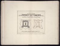
- Beinecke Rare Book and Manuscript Library > References for the plan of the city and suburbs of Carthagena
- Creator:
- Bowen, Thomas, d. 1790
- Published / Created:
- 1774 September 6
- Call Number:
- 1973 Folio 67
- Collection Title:
- The West-India pilot: containing piloting directions for Port Royal and Kingston harbours in
- Image Count:
- 1
- Subject (Topic):
- Harbors --Atlantic Coast (North America
- Found in:
- Beinecke Rare Book and Manuscript Library > View of Truxillo Bay and city on the coast of Honduras
- Creator:
- Thornton, John, 1641-1708
- Call Number:
- 1973 Folio 76
- Collection Title:
- The English pilot: describing the sea-coasts, capes, head-lands, rivers, bays, roads, havens
- Image Count:
- 1
- Subject (Geographic):
- North America --Maps --Early works to
- Found in:
- Beinecke Rare Book and Manuscript Library > A chart of ye north part of America
- Call Number:
- 1974 Folio 72
- Collection Title:
- The English pilot: describing the West-India navigation, from Hudson's-Bay to the river Amazones
- Image Count:
- 1
- Subject (Geographic):
- North America --Maps --Early works to
- Found in:
- Beinecke Rare Book and Manuscript Library > A new and correct chart of the western and southern oceans
- Call Number:
- 1973 Folio 116
- Collection Title:
- The English pilot: describing the West-India navigation, from Hudson's-Bay to the river Amazones
- Image Count:
- 2
- Subject (Geographic):
- North America --Maps --Early works to
- Found in:
- Beinecke Rare Book and Manuscript Library > A new and correct chart of the western and southern oceans
- Call Number:
- 1973 Folio 114
- Collection Title:
- The English pilot: describing the West-India navigation, from Hudson's-Bay to the river Amazones
- Image Count:
- 1
- Resource Type:
- Maps, Atlases & Globes
- Subject (Geographic):
- North America --Maps --Early works to
- Found in:
- Beinecke Rare Book and Manuscript Library > A new and correct chart of the western and southern oceans ...
- Creator:
- Harris, I., d. 1739
- Call Number:
- 1978 Folio 10
- Collection Title:
- The English pilot: describing the West-India navigation, from Hudson's-Bay to the river Amazones
- Image Count:
- 1
- Subject (Geographic):
- North America --Maps --Early works to
- Found in:
- Beinecke Rare Book and Manuscript Library > A new and correct chart shewing the variations of the compass in the western & southern oceans
- Call Number:
- 1974 Folio 72
- Collection Title:
- The English pilot: describing the West-India navigation, from Hudson's-Bay to the river Amazones
- Image Count:
- 2
- Subject (Geographic):
- Atlantic Coast (North America) --Maps
- Found in:
- Beinecke Rare Book and Manuscript Library > A generall chart of the western ocean
- Call Number:
- 1974 Folio 72
- Collection Title:
- The English pilot: describing the West-India navigation, from Hudson's-Bay to the river Amazones
- Image Count:
- 1
- Subject (Geographic):
- North America --Maps --Early works to
- Found in:
- Beinecke Rare Book and Manuscript Library > A new generall chart for the West Indies
- Call Number:
- 1978 Folio 10
- Collection Title:
- The English pilot: describing the West-India navigation, from Hudson's-Bay to the river Amazones
- Image Count:
- 1
- Subject (Geographic):
- North America --Maps --Early works to
- Found in:
- Beinecke Rare Book and Manuscript Library > A new generall chart for the West Indies
- Call Number:
- 1973 Folio 116
- Collection Title:
- The English pilot: describing the West-India navigation, from Hudson's-Bay to the river Amazones
- Image Count:
- 1
- Subject (Geographic):
- North America --Maps --Early works to
- Found in:
- Beinecke Rare Book and Manuscript Library > A new generall chart for the West Indies
- Call Number:
- 1973 Folio 114
- Collection Title:
- The English pilot: describing the West-India navigation, from Hudson's-Bay to the river Amazones
- Image Count:
- 2
- Resource Type:
- Maps, Atlases & Globes
- Subject (Geographic):
- North America --Maps --Early works to
- Found in:
- Beinecke Rare Book and Manuscript Library > A new generall chart for the West Indies
- Creator:
- Thornton, John, 1641-1708
- Call Number:
- 1973 Folio 76
- Collection Title:
- The English pilot: describing the sea-coasts, capes, head-lands, rivers, bays, roads, havens
- Image Count:
- 1
- Subject (Geographic):
- North America --Maps --Early works to
- Found in:
- Beinecke Rare Book and Manuscript Library > A generall chart of the West Indies