Maps numbered in manuscript 1 to 97; wanting 2, 42, 45, 51, 52, 74, 85, 89, 92 and 93., Some maps dated 1704-1717, others without date., Some maps first published in J. van Keulen's De nieuwe groote lichtende zee-fackel and G. van Keulen's De groote nieuwe vermeerderde zee-atlas., Title devised by cataloger., and With engraved title-page: "Gedruckt tot Amsterdam bÿ Ioannes van Keulen, boeck zee-kaardt verkooper en graad-boogh maker aande oost zÿde vande Nieuwebrug inde gekroonde Lootsman. Met previlegie ... 1718"; engraved title-page has same illustration as J. van Keulen's De groote nieuwe vermeerderde zee-atlas ofte water-werelt ... 1681.
Publisher:
s.n.,
Subject (Name):
Keulen, Gerard van., Keulen, Johannes van, 1654-1715. Groote nieuwe vermeerderde zee-atlas ofte water-waereld., Keulen, Johannes van, 1654-1715. Nieuwe groote lichtende zee-fakkel., Schenk, Peter, 1660-1718 or 1719., and Valck, G. (Gerard), 1651 or 1652-1726.
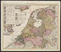
Appeared in Willem and Joan Blaeu's Theatrum orbis terrarum., Backed with linen., Coordinates not present on map and are approximated., Relief shown pictorially., and With north oriented towards the upper right.
Subject (Geographic):
Netherlands--Maps--Early works to 1800
Subject (Name):
Blaeu, Joan, 1596-1673. Theatrum orbis terrarum, Blaeu, Willem Janszoon, 1571-1638. Theatrum orbis terrarum, and Ende, Josua van den, approximately 1584-approximately 1634, engraver
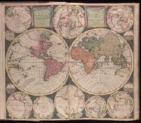
Vlakke aard-kloot gemeenlyk genaamd de geheele waereld
Description:
Backed with paper. Sheet measures 53.6 x 61.9 cm. No. 1 of 87 maps bound together., Includes twelve ancillary maps., Relief shown pictorially., Scale determined by using graticule method., and Watermark.
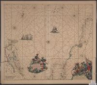
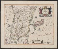
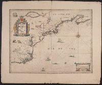
Terra neuf, en de custen van Nieu Vranckryck, Nieu Engeland, Nieu Nederland, Nieu Andalusia, Guiana en Venezuela
Description:
At upper right corner: Fol. 26., Covers the Atlantic Ocean west of, From Renard's Atlas de la navigation et du commerce ... Amsterdam : Chez Louis Renard, 1715., In Latin and Dutch., Includes two decorative cartouches and ill., and Oriented with north to the left.
Publisher:
Gedruckt by L. Renard,
Subject (Geographic):
North Atlantic Ocean--Maps--Early works to 1800
Subject (Name):
Renard, Louis. Atlas de la navigation et du commerce
Subject (Topic):
Nautical charts--North Atlantic Ocean--Early works to 1800
Terra Neuf, en de custen van Nieu Engeland, Nieu Nederland, Nieu Andalusia, Guiana en Venezuela
Description:
Covers the Atlantic Ocean west of the Azores and Cape Verde Islands, and the coasts of northeastern North America and northern South Amerca., Fr, In Latin and Dutch., Includes two decorative cartouches and ill., North oriented to left., and With "22" at top right.
Publisher:
Gedruckt by Fredrick de Wit in de Kalverstrae,
Subject (Geographic):
Atlantic Provinces--Maps--Early works to 1800 and North Atlantic Ocean--Maps--Early works to 1800
Subject (Name):
Wit, Frederik de. Orbis Maritimus ofte Zee Atlas
Subject (Topic):
Nautical charts--Atlantic Ocean--Early works to 1800
"Cum privil.", "I. Bormeester, eccu.", Bar scales given in "Gemene Duÿtsche Mÿlen 15 in een Graedt" and "Uren gaens de 4 maken 3 Mÿlen"., BEIN 1973 Folio 18: Backed with paper. Ms. no. "41" in upper-right corner. Sheet measures 53.6 x 62.7 cm. No. 40 of 87 maps bound together., Inset: De resterende Eÿlanden van Hollant alhier bÿgevoecht., North oriented to the upper-right., Prime meridian: Ferro., Relief shown pictorially., and Title in Latin; place names in Dutch.
Cross Collection no. 350., From Jodocus Hondius's Appendix Atlantis majoris. [Amsterdam] : Per Iodocum Hondium, 1630., Imperfect: mutilated along fold at bottom, with no loss of text. Mounted on linen., Map of the Straits of Magellan, South America., Relief shown pictorially., and Title in Latin; place names in Dutch.
Publisher:
Judocus Hondius excudit,
Subject (Geographic):
Magellan, Strait of (Chile and Argentina)--Maps--Early works to 1800
Subject (Name):
Gryp, Dirck, engraver and Hondius, Jodocus, 1594 or 1595-1629. Appendix Atlantis majoris
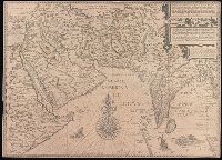
Afbeeldinge der custen van Abex, der engte van Mecha, anders ghenaempt de Roode Zee, Item de custen van Arabien, Ormus, Persen tot Sinde toe and Deliniantur in hac tabula, Orae maritimae Abexiae, freti Mecani ; al. Maris Rubri ; Arabiae, Ormi, Persiae, suprà Sindam usque Fluminis Indi, Cambaiae Indiae et Malabaris, Insulae Ceylon, Choromandeliae, et Orixae, fluvii Gangis, et Regni Bengalae, situs item Sinuum, Insularum
Description:
Backed with paper., From the author's Itinerario, voyage ofte schipvaert van Jan Huygen van Linschoten naer Oost ofte Portugaels Indien., Includes decorative cartouche and compass rose., Relief shown pictorially., and Title in Latin and Dutch. Place names in Latin and Dutch.
Publisher:
[Cornelis Claesz?],
Subject (Geographic):
Africa, Eastern--Maps--Early works to 1800., India--Maps--Early works to 1800., and Iran--Maps--Early works to 1800.
Subject (Name):
Langren, Henricus F. ab (Henricus Florentius), approximately 1574-1648. and Linschoten, Jan Huygen van, 1563-1611. Itinerario, voyage ofte schipvaert van Jan. Huygen van Linschoten naer Oost ofte Portugaels Indien.
Exacta et accurata delineatis cum orarum maritimarum tum etjam locorum terrestrium and Waarachtige wtworpinghe ofte afbeeldinge van alle dje custen end landen
Description:
Appears in the author's Itinerario. 1596., Backed with paper., Has watermark., Includes ill., Latin and Dutch., Oriented with north to the left., and Relief shown pictorially.
Publisher:
C. Claesz,
Subject (Geographic):
Southeast Asia--Maps--Early works to 1800
Subject (Name):
Langren, Arnold Florent van, 1580-1644, Langren, Henricus F. ab (Henricus Florentius), ca. 1574-1648, engraver, Linschoten, Jan Huygen van, 1563-1611, and Linschoten, Jan Huygen van, 1563-1611. Itinerario, voyage ofte schipvae
Subject (Topic):
Nautical charts--South China Sea--Early works to 1800 and Nautical charts--Southeast Asia--Early works to 1800
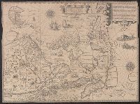
Appears in various eds. of Jansson's Nieuwen atlas., Dutch text on verso., Includes ill. of ships and sea monsters, and insets showing "Polus Arcticus" region and "Terra Australis incognita.", Relief shown pictorially., and Sheet measures 50.1 x 60.9 cm.
Covers North America, Cent, Dutch text on verso, with signature "Bb.", Relief shown pictorially., and State 2, first issued in 1641, according to Burden; matches description of Dutch text versions appearing in Nieuwen atlas editions 1645, '47, '52, '53, and '58.
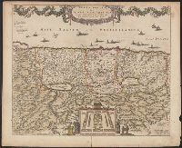
Coordinates not present on map and are approximated., From Joan Blaeu's Atlas maior (1662)., Latin text on verso; paginated ij-j, with caption Belgica., Relief shown pictorially., and With north oriented towards the upper right.
Subject (Geographic):
Netherlands--Maps--Early works to 1800
Subject (Name):
Blaeu, Joan, 1596-1673. Atlas maior, Ende, Josua van den, approximately 1584-approximately 1634, engraver, and Typographia Blaviani
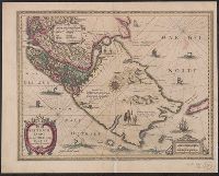
Dutch text on verso, with running and caption title "Virginia," signature 2D, and catchword "riviere.", Hendrik Hondius' derivative of John Smith's map of Virginia, 1612., Oriented with north toward the right., Relief shown pictorially., and Royal arms in upper r
Publisher:
Ex officina Henrici Hondii,
Subject (Geographic):
Chesapeake Bay (Md. and Va.)--Maps--Early works to 1800, Maryland--Maps--Early works to 1800, and Virginia--Maps--Early works to 1800
Subject (Name):
Jansson, Jan, 1588-1664. Atlas novus. Dutch and Smith, John, 1580-1631
Appears in various Dutch eds. of Blaeu's Theatrum orbis terrarum., Bar scales in "Miliaria Germanica communia" and "Miliaria Gallica communia.", In Dutch on verso, with caption title "Peru" and signature Y., Oriented with north to the left., Relief shown pictorially., and Sheet measures 47.3 x 61.4 cm.
Publisher:
Guiljelmus Blaeuw excudit,
Subject (Geographic):
Peru--Maps--Early works to 1800
Subject (Name):
Blaeu, Willem Janszoon, 1571-1638. Theatrum orbis terrarum. Dutch
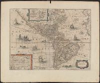
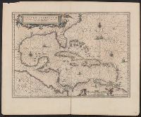
Insulae Americanae in Oceano Septentrionali cum terris adjacentibus and Insvlae Americanae in Oceano Septentrionali cum terris adiacentibus
Description:
Appears in various Dutch eds. of Jansson's Nieuwen atlas., Includes scales in milliaria germanica and mill, and Shows southeast coast of North America from Virginia to north coast of South America to east of Trinidad, west coast of Central America, West Indies.
Publisher:
Apud Ioannem Ianssonium,
Subject (Geographic):
Caribbean Area--Maps--Early works to 1800, Mexico, Gulf of--Maps--Early works to 1800, and West Indies--Maps--Early works to 1800
Subject (Name):
Jansson, Jan, 1588-1664. Atlas novus. Dutch
Subject (Topic):
Coasts--North America--Maps--Early works to 1800 and Coasts--South America--Maps--Early works to 1800
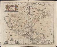
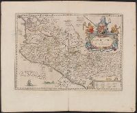
Dutch text of verso, with caption title "Nieuvv Spanien" and signature 2G., From Jansson's Nieuwen atlas ... Amstelodami : Apud Ioannem Ianssonium, 1647., Includes ill., index, and text., and Relief shown pictorially.
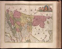
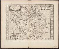
Atlas novus. and Gallia vetus ad Julij Caesaris commentaria
Description:
Latin text on recto; Dutch text on verso., Lower left corner: "Amstelodami apud Ioannem Ianβonium.", Published in Dutch editions of Jansson's Atlas novus (Dutch title: Nieuwen atlas, ofte vveerelts-beschrijvinge), vol. 6, ca. 1662, and Relief shown pictorially.
Publisher:
Jan Jansson,
Subject (Geographic):
France--History--To 987--Maps--Early works to 1800 and Gaul--Maps--Early works to 1800
Appears in Dutch editions of Jansson's Atlas novus., Dutch text on verso, with catchword "West-Indien" and signature 2C., Hand col. Sheet measures 50 x 60.5 cm., Ill. of animals and Indian village., and Relief shown pictorially.
Publisher:
Johannes Janssonius excudit,
Subject (Geographic):
Atlantic States--Maps--Early works to 1800 and Maritime Provinces--Maps--Early works to 1800
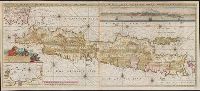
Also shows p, Includes text, col. view of Jakarta, inset of Jakarta, and some cities are marked with gilt., Library copy joined to form 1 sheet., Pars occidentalis --, Prime meridian: Ferro., and Title and notes in Latin. Place-names and scale statements in Dutch.
Publisher:
by Gerard van Keulen aan de Nieuwe brug met previlegie,
Subject (Geographic):
Jakarta (Indonesia)--Maps--Early works to 1800 and Java (Indonesia)--Maps--Early works to 1800
"Cum privil.", Appears in Schenk's Atlas contractus ... [Amsterdam : Peter Schenk, ca. 1700]., Imperfect: Mutilated, with some loss of text. Sheet measures 53.5 x 62 cm. Verso: "19" (?) in ink ms., Insets: Batavorum colon, and Relief shown pictorially.
Publisher:
Peter Schenk?
Subject (Geographic):
East Indies--Maps--Early works to 1800, Netherlands--Maps--Early works to 1800, and New Netherland--Maps--Early works to 1800
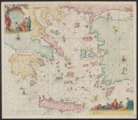
"Met priviligie voor 15 Iaar.", Appears in the author's De groote niewe vermeerderde zee-atlas ofte water-waereld., Dutch, with Latin place names., Has watermark., and Includes col. ill., decorative cartouche, and rhumb lines.
Publisher:
By Ioannes van Keulen, boeck verkooper en graad boogh maker, aen de N:Brugh inde gekroonde Loots,
Subject (Geographic):
Aegean Islands (Greece and Turkey)--Maps--Early works to 1800 and Crete (Greece)--Maps--Early works to 1800
Subject (Name):
Keulen, Johannes van, 1654-1715. Groote nieuwe vermeerderde zee-atlas ofte water-waereld
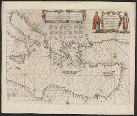
"20" in upper right corner., Along the top of the map is a garland supported by a cherubim; at bottom center, the encapment of the tribes flanked by Moses and Aaron is pictured., Appears in various editions of Wit's Atlas., Relief shown pictorially., and Sheet me
Publisher:
Gedruckt tot Amsterdam by Frederick de Wit in de Calverstraet by den Dam inde Witte Paskaert,
Subject (Geographic):
Palestine--History--To 70 A.D.--Maps and Palestine--Maps--Early works to 1800
Affbeeldinghe der custen des landts genaempt terra do Natal, item van alle de custen van Coffala, Mozambique, Melinde and Typus orarum maritimarum Guineae, Manicongo, & Angôlae ultra promontorium Bonae Spei.
Description:
Appears in the author's Itinerario, voyage ofte schipvaert van Jan Huygen van Linschoten naer Oost ofte Portugaels Indien., Companion map to Typus orarum maritimarum Guineae, Manicongo, & Angôlae ultra promontorium Bonae Spei ..., and Includes decorative carto
Publisher:
Cornelis Claesz?,
Subject (Geographic):
Africa, Eastern--Maps--Early works to 1800
Subject (Name):
Claesz, Cornelis, approximately 1546-1609, Langren, Arnold Florent van, 1580-1644, and Linschoten, Jan Huygen van, 1563-1611. Itinerario, voyage ofte schipvaert van Jan Huygen van Linschoten naer Oost ofte Portugaels Indien
Subject (Topic):
Coasts--Africa, Eastern--Maps--Early works to 1800
Affbeeldinghe der custen des landts genaempt terra do Natal, item van alle de custen van Coffala, Mozambique, Melinde and Typus orarum maritimarum Guineae, Manicongo, & Angôlae ultra promontorium Bonae Spei.
Description:
Appears in the author's Itinerario, voyage ofte schipvaert van Jan Huyge, Companion map to Typus orarum maritimarum Guineae, Manicongo, & Angôlae ultra promontorium Bonae Spei ..., Has watermark., and Includes decorative cartouche and compass rose and col. ill.
Publisher:
Cornelis Claesz?,
Subject (Geographic):
Africa, Eastern--Maps--Early works to 1800
Subject (Name):
Claesz, Cornelis, approximately 1546-1609, Langren, Arnold Florent van, 1580-1644, and Linschoten, Jan Huygen van, 1563-1611. Itinerario, voyage ofte schipvaert van Jan Huygen van Linschoten naer Oost ofte Portugaels Indien
Subject (Topic):
Coasts--Africa, Eastern--Maps--Early works to 1800
Afheeldinghe der custen des landts Guinea, Manicongo, ende Angôla, ende voorts tot voorby de C. de boa esperança and Delineatio orarum maritimarum, terrae vulgo indigetatae terra do Natal item Sofalae, Mozambicae & Melindae ...
Description:
Appears in the author's, Companion map to Delineatio orarum maritimarum, terrae vulgo indigetatae terra do Natal item Sofalae, Mozambicae & Melindae ..., Has watermark., Relief shown pictorially., and Title in Latin and Dutch. Place names in Latin and Portuguese.
Publisher:
Arnold Florent van Langren,
Subject (Geographic):
Africa, Southern--Maps--Early works to 1800
Subject (Name):
Langren, Arnold Florent van, 1580-1644 and Linschoten, Jan Huygen van, 1563-1611. Itinerario, voyage ofte schipvaert van Jan Huygen van Linschoten naer Oost ofte Portugaels Indien
Subject (Topic):
Coasts--Africa, Southern--Maps--Early works to 1800
Afheeldinghe der custen des landts Guinea, Manicongo, ende Angôla, ende voorts tot voorby de C. de boa esperança and Delineatio orarum maritimarum, terrae vulgo indigetatae terra do Natal item Sofalae, Mozambicae & Melindae ...
Description:
Appears in the author's Itinerario, voyage ofte schipvaert van Jan Huygen van Linschoten naer Oost ofte Portugaels Indien., Includes views of Ascension Island and Sain, Relief shown pictorially., and Title in Latin and Dutch. Place names in Latin and Portuguese.
Publisher:
Arnold Florent van Langren,
Subject (Geographic):
Africa, Southern--Maps--Early works to 1800
Subject (Name):
Langren, Arnold Florent van, 1580-1644 and Linschoten, Jan Huygen van, 1563-1611. Itinerario, voyage ofte schipvaert van Jan Huygen van Linschoten naer Oost ofte Portugaels Indien
Subject (Topic):
Coasts--Africa, Southern--Maps--Early works to 1800
Terra neuf, en de custen van Nieu Vranckryck, Nieu Engeland, Nieu Nederland, Nieu Andalusia, Guiana en Venezuela
Description:
Covers the Atlantic Ocean west of the Azores and Cape Verde Islands, and the coasts of northeastern North America and northern South Amerca., In Latin and Dutch., Includes two decorative cartouches and ill., Ms. "25" in upper right margin., and Oriented with nort
Publisher:
Gedruckt by Fredrick de Wit in de Kalverstraet,
Subject (Geographic):
North Atlantic Ocean--Maps--Early works to 1800
Subject (Topic):
Nautical charts--North Atlantic Ocean--Early works to 1800
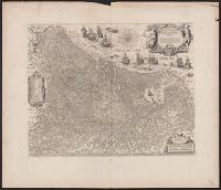
Charts and title pages in English, text in Dutch., Map oriented with North at bottom left., and Volvelle on p. [17].
Publisher:
Jodocus Hondius excudit,
Subject (Geographic):
Europe --Maps --Early works to 1800, Great Britain --Maps --Early works to 1800, Netherlands --Maps --Early works to 1800, and North Sea --Maps --Early works to 1800