Search
You Searched For
Search Results
- Creator:
- Moll, Herman, d. 1732
- Call Number:
- 85 1745A
- Container / Volume:
- BRBL_00636
- Image Count:
- 1
- Resource Type:
- Maps, Atlases & Globes
- Subject (Topic):
- Coasts--North America--Maps--Early
- Found in:
- Beinecke Rare Book and Manuscript Library > A chart of ye West-Indies or the islands of America in the North Sea &c., being ye present seat of war / by Herman Moll, geographer.
- Creator:
- Hooker, William
Jones, Benjamin
- Call Number:
- 1974 +231
- Collection Title:
- A new and elegant general atlas, comprising all the new discoveries, to the present time
- Image Count:
- 1
- Subject (Geographic):
- North America--Maps
- Found in:
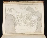
- Beinecke Rare Book and Manuscript Library > British possessions in America
- Creator:
- Lewis, Samuel, 1753 or 4-1822
- Call Number:
- 1974 +231
- Collection Title:
- A new and elegant general atlas, comprising all the new discoveries, to the present time
- Image Count:
- 1
- Subject (Geographic):
- North America--Maps
- Found in:
- Beinecke Rare Book and Manuscript Library > [Map of the Louisiana Territory]
- Published / Created:
- Undated
- Call Number:
- Taylor 355
- Collection Title:
- America painted to the life. The true history of the Spaniards proceedings in the conquests of the
- Image Count:
- 1
- Subject (Geographic):
- North America --Maps --Early works to
- Found in:
- Beinecke Rare Book and Manuscript Library > Americae descrip
- Call Number:
- 735 1790
- Container / Volume:
- BRBL_00689
- Image Count:
- 1
- Resource Type:
- Maps, Atlases & Globes
- Subject (Geographic):
- North America--Maps--Early works to
- Found in:
- Beinecke Rare Book and Manuscript Library > A map shewing the communication of the lakes and the rivers between Lake Superior and Slave Lake in North America.
- Call Number:
- BrSides Double Folio 2017 38
- Image Count:
- 1
- Resource Type:
- Maps, Atlases & Globes
- Subject (Geographic):
- North America--Maps--Early works to
- Found in:
- Beinecke Rare Book and Manuscript Library > The theatre of war in North America, with the roads, and tables, of the superficial contents, distances, & ca. / by an American.
- Creator:
- Hooker, William
Jones, Benjamin
- Call Number:
- 1974 +231
- Collection Title:
- A new and elegant general atlas, comprising all the new discoveries, to the present time
- Image Count:
- 1
- Subject (Geographic):
- North America--Maps
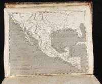
- Found in:
- Beinecke Rare Book and Manuscript Library > Spanish dominions in North America
- Creator:
- Marshall, Thomas
- Call Number:
- 1974 +231
- Collection Title:
- A new and elegant general atlas, comprising all the new discoveries, to the present time
- Image Count:
- 1
- Subject (Geographic):
- North America--Maps
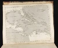
- Found in:
- Beinecke Rare Book and Manuscript Library > West Indies
- Call Number:
- 1976 1233
- Collection Title:
- Forty-two new maps of Asia, Africa, and America ... : all engrav’d, according to the latest
- Image Count:
- 1
- Subject (Geographic):
- North America --Maps --Early works to
- Found in:
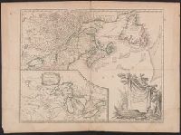
- Beinecke Rare Book and Manuscript Library > A map of America according to ye newest and most exact observations
- Creator:
- Robert de Vaugondy, Gilles, 1688-1766, cartographer.
- Call Number:
- 73 1785
- Image Count:
- 1
- Resource Type:
- Maps, Atlases & Globes
- Subject (Geographic):
- Great Lakes Region (North America
- Found in:
- Beinecke Rare Book and Manuscript Library > Partie de l'Amérique septent? qui comprend la Nouvelle France ou le Canada / par le Sr. Robert de Vaugondy, géog? ordinaire du Roy ; Graux.