Search
You Searched For
Search Results
- Creator:
- Wit, Frederik de
- Published / Created:
- [1720?]
- Call Number:
- 11 1720A
- Container / Volume:
- BRBL_00680
- Image Count:
- 1
- Resource Type:
- Maps, Atlases & Globes
- Found in:
- Beinecke Rare Book and Manuscript Library > Nova orbis tabula in lucem edita / a. F. de Wit.
- Creator:
- Senex, John, d. 1740
- Published / Created:
- 1720]
- Call Number:
- 11 1720B
- Container / Volume:
- BRBL_00680
- Image Count:
- 1
- Resource Type:
- Maps, Atlases & Globes
- Found in:
- Beinecke Rare Book and Manuscript Library > A new map of the world [cartographic material] : from the latest observations / revised by I. Senex.
- Creator:
- Moll, Herman, d. 1732
- Published / Created:
- [after 1754]
- Call Number:
- 11 1728
- Container / Volume:
- BRBL_00680
- Image Count:
- 1
- Resource Type:
- Maps, Atlases & Globes
- Found in:
- Beinecke Rare Book and Manuscript Library > A new and correct map of the world laid down according to the newest discoveries and from the most exact observations / [cartographic material] / by Herman Moll, geographer.
- Creator:
- Moll, Herman, -1732
- Published / Created:
- [1729?]
- Call Number:
- 11 1724
- Container / Volume:
- BRBL_00680
- Image Count:
- 1
- Resource Type:
- Maps, Atlases & Globes
- Found in:
- Beinecke Rare Book and Manuscript Library > A new and correct map of the world laid down according to the newest discoveries, and from the most exact observations / [cartographic material] / by Herman Moll, geographer.
- Creator:
- Lowitz, G. M. (George Moritz), 1722-1774
- Published / Created:
- 1746
- Call Number:
- 11 1746A
- Container / Volume:
- BRBL_00681
- Image Count:
- 1
- Resource Type:
- Maps, Atlases & Globes
- Found in:
- Beinecke Rare Book and Manuscript Library > Planiglobii terrestris mappa universalis utrumq[ue] hemisphaerium orient. et occidentale repraesentans, ex IV. mappis generalibus, Hasianis composita et adjectis ceteris hemisphaeriis / designata a G.M. Lowizio ; excudentibus Homann. Heredibus = Mappe-mon
- Creator:
- Bellin, Jacques Nicolas, 1703-1772
- Published / Created:
- 1748
- Call Number:
- 11 1748
- Container / Volume:
- BRBL_00681
- Image Count:
- 1
- Resource Type:
- Maps, Atlases & Globes
- Found in:
- Beinecke Rare Book and Manuscript Library > Versuch von einer Kurzgefassten Karte welche die bekannten Theile der Erdkugel / [cartographic material] / enthaelt dem Hm. grafen von Maurepas ; zugeeignet von N. Bellin.
- Creator:
- Tirion, Isaak
- Published / Created:
- 1744
- Call Number:
- 11 1744A
- Container / Volume:
- BRBL_00681
- Image Count:
- 1
- Resource Type:
- Maps, Atlases & Globes
- Found in:
- Beinecke Rare Book and Manuscript Library > Wereld kaart [cartographic material] : na de alderlaatste ontdekking in't licht gebragt / by Isaak Tirion.
- Creator:
- Zuerner, Adam Friedrich, 1680-1742
- Published / Created:
- [1709?]
- Call Number:
- 11 1709
- Container / Volume:
- BRBL_00680
- Image Count:
- 1
- Resource Type:
- Maps, Atlases & Globes
- Found in:
- Beinecke Rare Book and Manuscript Library > Planisphaerium terrestre cum utroque coelesti hemisphaerio, sive diversa orbis terraquei = Vlakke aard-kloot met het beide hemelsch half-rond, of de onder scheidene verbeelding van de land-water-waereld / opera et studio A.F. Zürneri.
- Creator:
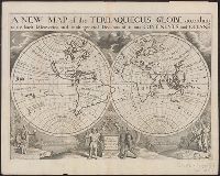
- Wells, Edward, 1667-1727
- Published / Created:
- 1726 or 1738]
- Call Number:
- 11 1701A
- Container / Volume:
- BRBL_00680
- Image Count:
- 1
- Resource Type:
- Maps, Atlases & Globes
- Found in:
- Beinecke Rare Book and Manuscript Library > A new map of the terraqueous globe : according to the latest discoveries and most general divisions of it into continents and oceans.
- Creator:
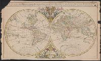
- Sanson, Nicolas, 1600-1667
- Published / Created:
- 1691?]
- Call Number:
- 11 1691
- Container / Volume:
- BRBL_00680
- Image Count:
- 1
- Resource Type:
- Maps, Atlases & Globes
- Found in:
- Beinecke Rare Book and Manuscript Library > Mappe-monde geo-hydrographique, ou, Description generale du globe terrestre et aquatique en deux-plans-hemispheres, ou sont exactement remarquées en general toutes les parties de la terre et de l'eau, suivant le relations les plus nouvelles [cartographic