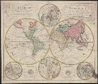
Lowitz, G. M. (George Moritz), 1722-1774, cartographer.
Call Number:
11 1746A
Image Count:
1
Resource Type:
Maps, Atlases & Globes
Alternative Title:
Mappe-monde qui représente les deux hemisphères savoir celui de l'orient et celui de l'occident, tirée des quatre cartes générales de feu M. le profess. Hasius and Planiglobii terrestris mappa vniversalis
Description:
Title in Latin and French.
Subject (Name):
Hase, Johann Matthias, 1684-1742. and Homann Erben (Firm), publisher.
Subject (Topic):
Religion--Maps--Early works to 1800. and World maps--Early works to 1800.
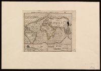
"DK," the initials of woodcutter David Kandel, appear in lower left-hand corner., Imperfect: torn along center fold, with some loss of text. Cross collection no. 5., and Map depicts the continents of Africa, Asia, Europe ("Europa"), and the New World, the coat of arms of Castile and León, sailing vessels, sea monsters, and twelve wind heads.
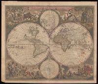
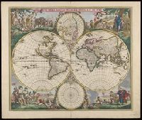
Allegorical vignettes of the four seasons., Double hemisphere, with smaller polar insets., Imperfect: chipped and mutilated along edges and fold, with some loss of text. Backed with paper., Relief shown pictorially., Shows California as an island., and State 2, in which cherubs were placed in the cusps and a border added; see Rodney Shirley, Mapping of the world, entry 451.
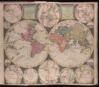
Allegorical vignettes of the four seasons., Double hemisphere, with smaller polar insets., Label on verso with manuscript number "101/61." Manuscript notes on verso: A.K. 481; no. 3; de Wit, 1660 [crossed out] 1677. Cross collection no. 26., Relief shown pictorially., Shows California as an island., and State 2, in which cherubs were placed in the cusps and a border added; see Rodney Shirley, Mapping of the world, entry 451.
Allegorical vignettes of the four seasons., Double hemisphere, with smaller polar insets., Relief shown pictorially., Shows California as an island., and State 2, in which cherubs were placed in the cusps and a border added; see Rodney Shirley, Mapping of the world, entry 451.
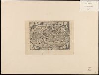
Vlakke aard-kloot gemeenlyk genaamd de geheele waereld
Description:
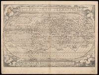
Backed with paper. Sheet measures 53.6 x 61.9 cm. No. 1 of 87 maps bound together., Includes twelve ancillary maps., Relief shown pictorially., Scale determined by using graticule method., and Watermark.
"Quid ei potest videri magnum in rebus humanis, cui aeternitas omnis, totiusque mundi nota sit magnitudo. Cicero"., Cross collection no. 7. Label on verso with manuscript number "101/58.", From Ortelius's Theatrum orbis terrarum., German text on verso, with caption title "Die gantsche Welt" and signature l., and Relief shown pictorially.
Publisher:
[Abraham Ortelius],
Subject (Name):
Hogenberg, Frans, approximately 1539-1590, engraver. and Ortelius, Abraham, 1527-1598. Theatrum orbis terrarum.