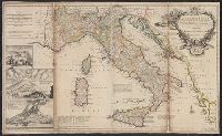
"Note: the post roads in this map are taken from Iacobo Cantelli da Vignola the Duke of Modena's geographer.", *40 1714: verso: stamped "Yale UL"; dgvmp2008., and Includes inset views of Caesium, Vesuvius, Aetna.
Publisher:
printed for H. Moll...Ino. Bowles...T. Bowles...Philip Overton,
Subject (Geographic):
Italy--Maps--Early works to 1800 and Mediterranean Region--Maps--Early works to 1800
Subject (Name):
Bowles, John, 1701-1779, Bowles, Thomas, -1767, Cantelli da Vignola, Giacomo, 1643-1719, and Overton, Philip, -1751
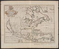
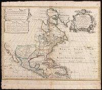
"Dedicated to His Highness William Duke of Glocester.", Dates inferred from variant listed in Tooley's Mapping of America, dated "[1700]" and variant in Phillips' Maps of America, described as in 1722 ed. of Wells' A new sett of maps., and Library's copy stampe
Publisher:
s.n.,
Subject (Geographic):
Caribbean Area--Maps--Early works to 1800 and North America--Maps--Early works to 1800
Subject (Name):
Burghers, M, University of Oxford, and Wells, Edward, 1667-1727. New sett of maps both of antient and present geography
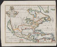
A generall chart of the West Indies -- Barbados [and] Bermudos with inset: St. Michaels or the Bridge Town -- Tobago -- Antego -- St. Christophers -- A new map of the Island of Jamaica with inset: The harour [i.e., harbour] of Port Royall., Except for the general chart and the inset of St. Michaels, each map has a bar scale. The maps of Barbados, Bemudos, Tobago, Antego and St. Christophers also have latitude values. The general chart and the map of Jamaica have latitude and longitude figures in the margins., From Senex's A new general atlas ... London : Printed for Daniel Brown ..., 1721., Includes bar scales in English miles., Mounted on linen. Cross Collection no. 241., and Relief shown pictorially.
Publisher:
s.n.,
Subject (Geographic):
Jamaica--Maps--Early works to 1800 and West Indies--Maps--Early works to 1800
Subject (Name):
Harris, John, 1667?-1719, engraver and Senex, John, d. 1740. New general atlas
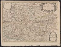
Appears in Senex's New general atlas., Cross collection no. 74., Dedicated to John Richmond Webb; dedication shows evidence of previous cartographer's name being removed and replaced by that of John Senex., London meridian., Relief shown pictorially., and Shows boundaries, rivers, forests and settlements.
Publisher:
John Senex],
Subject (Geographic):
Cambrai (France)--Maps--Early works to 1800, Hainaut (County)--Maps--Early works to 1800, and Namur (Belgium)--Maps--Early works to 1800
Subject (Name):
Senex, John, d. 1740, dedicator, Senex, John, d. 1740. New general atlas, and Webb, John Richmond, dedicatee
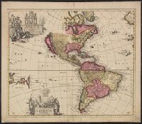
Imperfect; chipped along edges, with some loss of text. Manuscript number "j20" in upper right corner. Left side of Matthaeus Seutter map "Le pays de Perou et Chili ..." pasted onto verso., Includes five bar scales., and Relief shown pictorially.
Publisher:
Venalis prostat Augustae Vindel. apud Ieremiam Wolff,
Includes five bar scales., Relief shown pictorially., and Watermark. Manuscript number in upper right corner: jj5. Reinforced at bottom with paper. From the Karpinski Collection.
Publisher:
Venalis prostat Augustae Vindelic apud Jeremiam Wolff,
Subject (Geographic):
North America--Maps.
Subject (Name):
Karpinski, Louis Charles,--1878-1956--Ownership. and Wolf, Jeremias, 1663?-1724, pulbisher.