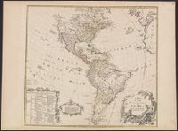
Includes text and ill., Library's copy annotated in ink in upper right corner, "12"; and on verso, annotated "Amérique 12" and stamped "Yale, Horace Brown, 1900S.", Relief shown pictorially., and Shows boundaries of lands claimed by the English, French, Spanish
Publisher:
s.n.,
Subject (Geographic):
America--Maps--Early works to 1800
Subject (Name):
Anville, Jean Baptiste Bourguignon d', 1697-1782, Bayly, J, Bellin, Jacques Nicolas, 1703-1772, and Bowles, Thomas, -1767
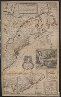
[South part of Carolina, and the east part of Florida], Draught of ye town and harbour of Charles-town, Map of the improved part of Carolina with the settlements, Map of the principal part of North America, and View of ye industry of ye beavers of Canada
Description:
Dedication: "To the honourable Walter Dowglass ... by ... Herman Moll ... ", Hand col. On sheet 104 x 64 cm. Recto: Stamped "Yale Horace Brown 1900S". Verso: Numbered "VIIIth" in ink ms.; labeled "English Dom: in N., and Publication date from Tooley.
Publisher:
Sold by H. Moll and by I. King at ye globe and ye poultrey near Stocks Market,
Subject (Geographic):
France--Colonies--America--Maps--Early works to 1800, Great Britain--Colonies--America--Maps--Early works to 1800, North America--Maps--Ear, and United States--History--Colonial period, ca. 1600-1775--Maps--Early works to 1800
Subject (Name):
Dowglass, Walter, dedicatee, King, John, fl. 1710-1749, publisher, and Moll, Herman, d. 1732, publisher
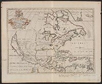
"Dedicated to His Highness William Duke of Glocester.", Dates inferred from variant listed in Tooley's Mapping of America, dated "[1700]" and variant in Phillips' Maps of America, described as in 1722 ed. of Wells' A new sett of maps., and Library's copy stampe
Publisher:
s.n.,
Subject (Geographic):
Caribbean Area--Maps--Early works to 1800 and North America--Maps--Early works to 1800
Subject (Name):
Burghers, M, University of Oxford, and Wells, Edward, 1667-1727. New sett of maps both of antient and present geography
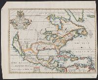