According to Kershaw this map is the second state., From: The English pilot, the fourth book, published between 1732 and 1749., and Map is showing shoals and depth is shown by soundings.
Publisher:
Sold by Willm. Mount & Tho. Page at the Postern on Great Tower Hill,
Subject (Geographic):
Atlantic Coast (North America)--Maps--Early works to 1800
Subject (Name):
Mount, William, d. 1769, bookseller and Page, Thomas, d. 1733, bookseller
Subject (Topic):
Nautical charts--Atlantic Coast (North America)--Early works to 1800
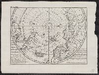
Atlas minor: or a set of sixty-two new and correct maps, of all parts of the world. All composed
Image Count:
1
Description:
Autograph of Gravely. Autograph of Baldock. Autograph of Aston. Autograph of W. Alington. and Teaching resource: Professor John Mack Faragher, History 141: The American West.
Subject (Geographic):
America--Maps--Early works to 1800 and Fundy, Bay of--Maps
Atlas minor: or a set of sixty-two new and correct maps, of all parts of the world. All composed
Image Count:
1
Resource Type:
Maps, Atlases & Globes
Description:
Autograph of Gravely. Autograph of Baldock. Autograph of Aston. Autograph of W. Alington. and Teaching resource: Professor John Mack Faragher, History 141: The American West.
Subject (Geographic):
America--Maps, Europe, Northern--Maps--Early works to 1800, Great Britain--Maps--Early works to 1800, and Ireland--Maps--Early works to 1800
America Septentrionalis., Sir Charles Wager's engagement with the fleet of Spanish men of war and galeons off of Cartagena., and Sr. Charles Wager's engagement with the fleet of Spanish men of war and galeons off of Cartagena.
Description:
"C. Lemprière, inv. & del., B. Baron, sculp." cf. plate 17., "London engraved by Willm. Henry Toms, 1733 " cf. plate 20., Accompanied by text: The contents of each sheet of the twenty plates of Mr. Popple's Map of America. 25 cm., Cross Collection no. 313., First issued in 1732., Includes 22 insets, ill., and text., Includes 4 views, 18 insets, view of "Sr. Charles Wager's engagement with the fleet of Spanish men of war ...," and descriptive notes., Relief shown pictorially. Depths shown by soundings., Sheet 18: "Sr. Charles Wager's engagement ..." Sheet measures 53.4 x 72.0 cm., Title in top margin of key map: America Septentrionalis., and Title taken from plate 20.
Publisher:
Sold by S. Harding ... and by W.H. Toms, engraver ...,
Subject (Geographic):
Great Britain--Colonies--America--Maps--Early works to 1800 and North America--Maps--Early works to 1800
Subject (Name):
Baron, Bernard, 1696-1762, Harding, S., fl. 1724-1741, Lemprière, Clement, and Toms, W. H. (William Henry), approximately 1700-approximately 1750
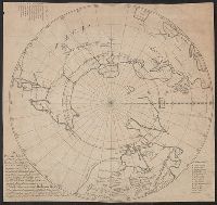
"Vol. I. p. 805" in upper left corner., Appears in: Atlas minor, or, A new and curious set of sixty-two maps. [London] : Printed for Tho: Bowles next ye Chapter House in St. Pauls Church Yard, & John Bowles at the Black Horse in Cornhill ..., [1736?], Cross collection no. 53., From: Thomas Salmon's Modern history. London : Printed for Messrs. Bettesworth and Hitch, J. Clarke, S. Birt, Tho. Wotton, and J. Shuckburgh, and T. Osborne, 1739., Includes text., and Relief shown pictorially.
Publisher:
Printed for Tho. Bowles next the Chapter house in St. Pauls church yard & Iohn Bowles at the Black Horse in Cornhill,
Subject (Geographic):
Arctic Regions--Maps--Early works to 1800 and North Pole--Maps--Early works to 1800
Subject (Name):
Bowles, John, 1701-1779, bookseller, Bowles, Thomas, -1767, bookseller, and Salmon, Thomas, 1679-1767. Modern history