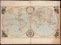
Hand coloured double hemispheric map of the world (Western hemisphere, or, the New World, and Eastern hemisphere, or, the Old World), with four decorative hand coloured vignettes representing Europe, Asia, America, and Africa., Includes an ornate compas rose and an elablorate title cartouche., Mounted on board., The map perpetuates some errors regarding the geography of the northwest coast of America., and Traces the voyages of some important explorers of the second half of the 18th century, including Cook's first voyage.
Publisher:
Printed for the Proprietor, Carington Bowles, No. 69, in St. Paul's Churchyard,
Delarochette, L. (Louis), 1731-1802, cartographer.
Call Number:
23 1794A
Image Count:
1
Resource Type:
Maps, Atlases & Globes
Alternative Title:
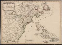
Chart of the northwest coast of America and the northeast coast of Asia, explored in the years 1778 and 1779
Description:
Below title: Advertisement, the interesting discoveries made by British and American ships since the first publication of this chart in 1784, together with the hydrographical materials lately procured from St. Petersburg and other places , have enabled Mr. De la Rochette to lay down the numerous improvements which appear in the present edition, Charing Cross, January 1st, 1794, W. Faden., Includes notes., Relief shown pictorially. Depths shown by soundings., and With watermark dated 1801.
Subject (Geographic):
Bering Strait Region--Discovery and exploration--Maps--Early works to 1800., North America--Discovery and exploration--Maps--Early works to 1800., Pacific Coast (North America)--Discovery and exploration--Maps--Early works to 1800., and Russian Far East (Russia)--Discovery and exploration--Maps--Early works to 1800.
Subject (Name):
Cook, James,--1728-1779., Faden, William, 1749-1836, publisher., Palmer, W. (William), 1739-1812, engraver., and Roberts, Henry, 1757-1796.
Subject (Topic):
Discoveries in geography. and Discoveries in geography--Maps--Early works to 1800.
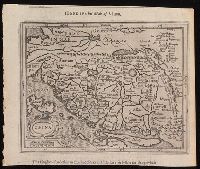
Hondius his map of China and Hondivs his map of China
Description:
North oriented towards the right., Relief shown pictorially., Removed from Samuel Purchas's Purchas his Pilgrimage (1625)., and Text in English on verso.
Publisher:
[Printed by William Stansby for Henrie Fetherstone],
Subject (Geographic):
China.
Subject (Name):
Featherstone, Henry, -1647, bookseller, Purchas, Samuel, 1577?-1626. Purchas his Pilgrimage. 1625., and Stansby, William, active 1597-1638, printer
Keere, Pieter van den, 1571-approximately 1646, cartographer.
Published / Created:
[between 1652 and 1684]
Call Number:
BrSides Double Folio 2019 103
Image Count:
1
Resource Type:
Maps, Atlases & Globes
Description:
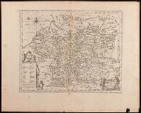
Appears in Jansson's historical atlas editions from 1652-1684., Manuscript number in upper left corner: 13., and Relief shown pictorially.
Publisher:
Apud Joannem Janssonium,
Subject (Geographic):
Benelux countries--Historical geography--Maps--Early works to 1800., Benelux countries--Maps--Early works to 1800., Europe, Central--Historical geography--Maps--Early works to 1800., and Europe, Central--Maps--Early works to 1
Subject (Name):
Jansson, Jan, 1588-1664, publisher.
Subject (Topic):
Ethnology--Europe--Maps--Early works to 1800. and Germanic peoples--Maps--Early works to 1800.
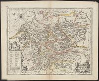
Appears in Jansson's historical atlas editions from 1652-1684., Hand colored., and Relief shown pictorially.
Publisher:
Apud Joannem Janssonium,
Subject (Geographic):
Benelux countries--Historical geography--Maps--Early works to 1800., Benelux countries--Maps--Early works to 1800., Europe, Central--Historical geography--Maps--Early works to 1800., Europe, Central--Maps--Early works to 1800., Europe, Eastern--Historical geography--Maps--Early works to 1800., Europe, Eastern--Maps--Early works to 1800., Germany--Historical geography--Maps--Early works to 1800., and Germany--Maps--Early works to 1800.
Subject (Name):
Jansson, Jan, 1588-1664
Subject (Topic):
Ethnology--Europe--Maps--Early works to 1800. and Germanic peoples--Maps--Early works to 1800.
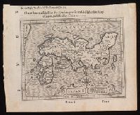
I haue heere added for the readers profit and delight this map of Iapan, published by I. Hondivs, I have heere added for the readers profit and delight this map of Iapan, published by I. Hondius, and Japan I.
Description:
Relief shown pictorially., Removed from Samuel Purchas's Purchas his Pilgrimage (1625)., and Text in English on verso with signature 3M3 at foot of map.
Publisher:
[Printed by William Stansby for Henrie Fetherstone],
Subject (Geographic):
Japan--Maps--Early works to 1800.
Subject (Name):
Featherstone, Henry, -1647, bookseller., Purchas, Samuel, 1577?-1626. Purchas his Pilgrimage. 1625., and Stansby, William, active 1597-1638, printer.
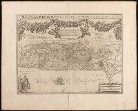
Imperatorskai︠a︡ akademīi︠a︡ nauk (Russia), cartographer, publisher.
Call Number:
23 1773
Image Count:
1
Resource Type:
Maps, Atlases & Globes
Description:
Includes title in embellished cartouche., Map of northwestern North America and the Russian Far East including the Bering Strait region showing the exploration routes of Bering, Chirikov, and other Russian explorers., and Relief shown pictorially.
Subject (Geographic):
Bering Strait Region--Discovery and exploration--Russian--Maps--Early works to 1800., North America--Discovery and exploration--Russian--Maps--Early works to 1800., and Russian Far East (Russia)--Discovery and exploration--Russian--Maps--Early works to 1800.
Subject (Topic):
Discoveries in geography--Maps--Early works to 1800. and Discovery and exploration, Russian.
Adrichem, Christiaan van, 1533-1585, cartographer.
Published / Created:
[between 1652 and 1684]
Call Number:
BrSides Double Folio 2019 97
Image Count:
1
Resource Type:
Maps, Atlases & Globes
Description:
Coordinates not present on map and are approximated., Manuscript number in upper left corner: 42., Oriented with north to the lower left., Relief shown pictorially., and Verso blank.
Caption title. and No other recorded copy of this work identified at time of cataloging.
Publisher:
Printed for H. Humphrey, no. 27, St. James's Street,
Subject (Geographic):
France.
Subject (Name):
Hoche, Lazare,--1768-1797., Humphrey, Hannah, active 1774-1817, publisher., and Project Unica (University of Illinois at Urbana-Champaign Library) IU-R
Subject (Topic):
Generals. and Generals--France--Early works to 1800.