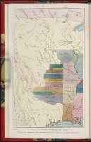
Search
You Searched For
Search Results
- Published / Created:
- 1801
- Call Number:
- Zc90 801mab
- Collection Title:
- Voyages from Montreal, on the river St. Laurence, through the continent of North America, to the
- Image Count:
- 1
- Found in:
- Beinecke Rare Book and Manuscript Library > A map of America, between latitudes 40 and 70 north and longitudes 45 and 180 west, exhibiting Mackenzie's track from Montreal to Fort Chipewyan & from thence to the North Sea In 1789 & to the West Pacific Ocean in 1793
- Published / Created:
- 1783
- Call Number:
- Cb21 35B
- Collection Title:
- History of the war with America, France, Spain, and Holland; commencing in 1775 and ending in 1783
- Image Count:
- 1
- Found in:
- Beinecke Rare Book and Manuscript Library > A Map of the United States of America, as settled by the peace of 1783
- Creator:
- Dunn, Samuel
- Published / Created:
- 1774
- Call Number:
- Cb23 27
- Collection Title:
- The American military pocket atlas : being an approved collection of correct maps, both general and
- Image Count:
- 1
- Found in:
- Beinecke Rare Book and Manuscript Library > North America as divided amongst the European powers
- Published / Created:
- 1776
- Call Number:
- Cb23 27
- Collection Title:
- The American military pocket atlas : being an approved collection of correct maps, both general and
- Image Count:
- 1
- Found in:
- Beinecke Rare Book and Manuscript Library > A General map of the northern British colonies in America. which comprehends the province of Quebec, the government of Newfoundland, Nova-Scotia, New-England and New-York. From the maps published by the Admiralty and Board of Trade regulated by the astronomic and trigonometric observations of M. von Holland and corrected from Governor Pownall's late map 1776.
- Published / Created:
- 1776
- Call Number:
- Cb23 27
- Collection Title:
- The American military pocket atlas : being an approved collection of correct maps, both general and
- Image Count:
- 1
- Found in:
- Beinecke Rare Book and Manuscript Library > A general map of the middle British colonies in America. Containing Virginia, Maryland, the Delaware counties, Pennsylvania and New Jersey. With the addition of New York, and of the greatest part of New England, as also of the bordering parts of the province of Quebec, improved from several surveys made after the late war, and corrected from Governor Pownall's late map 1776.
- Creator:
- Romans, B
- Published / Created:
- 1776
- Call Number:
- Cb23 27
- Collection Title:
- The American military pocket atlas : being an approved collection of correct maps, both general and
- Image Count:
- 1
- Found in:
- Beinecke Rare Book and Manuscript Library > A General map of the southern British colonies, in America, comprehending North and South Carolina, Georgia, east and west Florida, with the neighbouring Indian countries. From the modern surveys of engineer de Brahm, Capt. Collet, Mouzon & others; and from the large hydrographical survey of the coasts of east and west Florida
- Creator:
- Brasier, William
- Published / Created:
- 1776
- Call Number:
- Cb23 27
- Collection Title:
- The American military pocket atlas : being an approved collection of correct maps, both general and
- Image Count:
- 1
- Found in:
- Beinecke Rare Book and Manuscript Library > A Survey of Lake Champlain, including Lake George, Crown Point and St. John. Surveyed by order of His Excellency Major General Sr. Jeffery Amherst, knight of the most honble. Order of the Bath, Commander in Chief of His Majesty's forces in North America (now Lord Amherst) by William Brassier, draughtsman, 1762
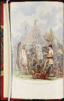
- Creator:
- Catlin, George, 1796-1872
- Published / Created:
- 1848
- Call Number:
- Zc12 +841cabj
- Image Count:
- 8
- Resource Type:
- Books, Journals & Pamphlets
- Found in:
- Beinecke Rare Book and Manuscript Library > Illustrations of the manners, customs, and condition of the North American Indians : in a series of letters and notes written during eight years of travel and adventure among the wildest and most remarkable tribes now existing. : with three hundred and si
- Creator:
- Catlin, George, 1796-1872
- Published / Created:
- 1848
- Call Number:
- Zc12 +841cabj
- Image Count:
- 7
- Found in:
- Beinecke Rare Book and Manuscript Library > Illustrations of the manners, customs, and condition of the North American Indians : in a series of letters and notes written during eight years of travel and adventure among the wildest and most remarkable tribes now existing. : with three hundred and si
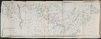
- Creator:
- Weller, Edward, d. 1884
- Call Number:
- Zc90 859ka
- Collection Title:
- Wanderings of an artist among the Indians of North America : from Canada to Vancouver's Island and
- Image Count:
- 1
- Found in:
- Beinecke Rare Book and Manuscript Library > Map to illustrate Mr. Kane's travels in the territory of the Hudson's Bay Company