
Search


Limit your search
- Public6,766
- Maps, Atlases & Globes✖[remove]6,766
- United States. Office of Strategic Services. Research and Analysis Branch193
- Rand McNally and Company192
- United States. Army Map Service171
- Great Britain. War Office. General Staff. Geographical Section142
- United States. General Land Office67
- Geological Survey (U.S.)60
- United States. Department of State. Division of Map Intelligence and Cartography42
- Wyld, James, 1812-188738
- G.W. & C.B. Colton & Co37
- National Geographic Society (U.S.). Cartographic Division36
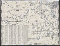
- Railroads--United States--Maps51
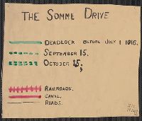
- World War, 1914-1918--Maps45
- World War, 1939-1945--Campaigns--Western Front--Historical geography--Maps36
- Railroads--West (U.S.)--Maps30
- Navigation --Early works to 180028
- Pilot guides --Atlantic Coast (U.S.) --Early works to 180028
- Pilot guides --Caribbean Area --Early works to 180028
- Railroads--Canada--Maps25
- Streets--California--Los Angeles--Maps23
- Railroads--Texas--Maps22
- Bien, Julius, 1826-190953
- United States. Army Map Service47
- Julius Bien & Co41
- Streeter, Thomas W.--(Thomas Winthrop),--1883-1965--Ownership33
- United States. General Land Office32
- United States. Office of Strategic Services. Reproduction Branch32
- Roeser, C. (Charles)29
- Senex, John, d. 1740. New general atlas25
- A. Hoen & Co22
- Churchill, Awnsham, -1728. Collection of voyages and travels. Danish.22