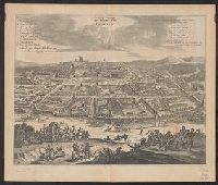
Bird's-eye view., Dutch and English., From Ogilby's Africa, being an accurate description of the regions of Egypt, Barbary, Lybia and Billedulgerid. 1670., Has watermarks., Includes ill. and indexes of points of interest., and Relief shown pictorially.
Publisher:
Printed by T. Johnson for the author,
Subject (Geographic):
Loango (Congo)--Aerial views--Early works to 1800
Subject (Name):
Ogilby, John, 1600-1676. Africa, being an accurate description of the regions of Egypt, Barbary, Lybia and Billedulgerid
Nieuhof, Johannes, 1618-1672 Ogilby, John, 1600-1676 Ogilby, John, 1600-1676. Africa, being an accurate description of the regions of Egypt, Barbary
Published / Created:
1670]
Call Number:
215 1670
Container / Volume:
BRBL_00015
Image Count:
1
Resource Type:
Maps, Atlases & Globes
Alternative Title:
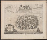
Saint Helena
Description:
Dutch and English., From Ogilby's Africa, being an accurate description of the regions of Egypt, Barbary, Lybia and Billedulgerid. 1670., Has watermarks., Includes ill. and indexes., Oriented with north toward the lower left., and Relief shown pictorially.
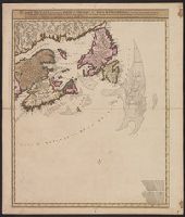
Carte nouvelle contenant la partie d'Amerique la plus septentrionale : ou sont exactement dêcrites les provinces suivantes comme le Canada ou Nouvelle France, la Nouvelle Ecosse, la Nouvelle Angleterre, les Nouveaux Paı̈s Bas, la Pensylvanie, la Virginie
Description:
Appears in some eds. of the author's
Publisher:
Nicolao Visscher,
Subject (Geographic):
Atlantic Provinces--Maps--Early works to 1800 and North America--Maps--Early works to 1800
Subject (Name):
Anse, Luggert van, fl. 1690-1716, engraver and Visscher, Nicolaes, 1649-1702. Atlas minor sive geographia compendiosa