Skip to search
Skip to main content
Skip to first result
Search
You Searched For
"New England"
Access
Public
Genre
Maps
Language
English
Subject (Topic)
Railroads--New England--Maps
New Search
Search Results
Creator:
Published / Created:
[1903]
Call Number:
76gme 1903
Container / Volume:
BRBL_00446A
Image Count:
1
Resource Type:
Maps, Atlases & Globes
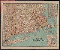
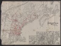
Abstract:
A color map showing the rail and marine routes operated by the New York, New Haven and Hartford Railroad, as well as connecting routes.
Alternative Title:
Pocket map of the New York, New Haven and Hartford Railroad lines
Description:
"12-4-'03", Covers attached to verso. Not digitized., and Includes insets of the Boston and New York Metropolitan Areas.
Publisher:
Poole Brothers,
Subject (Name):
New York, New Haven, and Hartford Railroad Company--Maps
Subject (Topic):
Ferries--New England --Maps
Found in:
Beinecke Rare Book and Manuscript Library > The New York, New Haven and Hartford Railroad and connections.
Creator:
Published / Created:
1898
Call Number:
76 1898
Container / Volume:
BRBL_00445
Image Count:
1
Resource Type:
Maps, Atlases & Globes
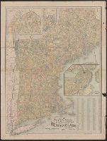
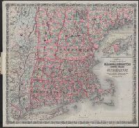
Alternative Title:
Map of New England showing state
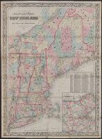
Description:
"Copyright 1897, by National Publishing Co.", Includes population of cities with over 2000 inhabitants., Insets: Map of Boston proper, Northern part of Maine, S.E. part of Maine., and Oriented with north toward the upper left.
Publisher:
National Pub. Co.,
Subject (Geographic):
New England --Maps
Subject (Topic):
Post Office Buildings--New England
Found in:
Beinecke Rare Book and Manuscript Library > New post office, township, county and railroad map of New England : with distances.
Creator:
Published / Created:
1852
Call Number:
76GM 1852
Container / Volume:
BRBL_00446
Image Count:
1
Resource Type:
Maps, Atlases & Globes
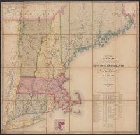
Alternative Title:
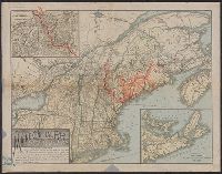
Telegraph and rail road map of the New
Description:
Entered according to act of Congress, in the year 1852, by Redding & Co. in the clerk's office of the District court of the United States for the district of Massachusetts. and Includes table showing the "cost of construction and equipment of all the rail roa
Publisher:
Redding & Co.,
Subject (Geographic):
New England --Maps
Subject (Name):
Redding & Co
Subject (Topic):
Railroads--New England --Maps
Found in:
Beinecke Rare Book and Manuscript Library > Williams' telegraph and rail road map of the New England states : Eastern portion of New York state and Canada/ compiled from the most authentic sources by Alexander Williams.
Creator:
Published / Created:
1885
Call Number:
753gme 1885
Container / Volume:
BRBL_00415
Image Count:
2
Resource Type:
Maps, Atlases & Globes
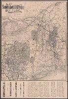
Alternative Title:
Boston & Lowell Railroad :
Description:
Covers New England excluding Maine, and
Publisher:
Rand Avery Supply Co.,
Subject (Name):
Boston and Lowell Railroad Corporation--Maps
Subject (Topic):
Railroads--New England --Maps
Found in:
Beinecke Rare Book and Manuscript Library > Map of the Boston & Lowell Railroad System : with its principal connections.
Creator:
Published / Created:
[1911?]
Call Number:
76gme 1910
Container / Volume:
BRBL_00446A
Image Count:
1
Resource Type:
Maps, Atlases & Globes
Alternative Title:
Boston and Maine Railroad and connections
Description:
St. Andrews N.B. and about there -- White Mountain region -- Mount Desert Island and vicinity.
Publisher:
The Company,
Subject (Geographic):
New England --Maps
Subject (Name):
Boston and Maine Railroad
Subject (Topic):
Railroads--New England --Maps
Found in:
Beinecke Rare Book and Manuscript Library > Boston & Maine Railroad and connections / Rand Avery Supply Co.
Creator:
Published / Created:
1886
Call Number:
76 1886
Container / Volume:
BRBL_00445
Image Count:
1
Resource Type:
Maps, Atlases & Globes
Alternative Title:
Massachusetts, Rhode Island, and Connecticut and Railroad & township map of Massachusetts, Rhode Island, and Connecticut
Description:
"Entered according to Act of Congress in the Year 1860 by J.H. Colton in the Clerks Office of the District Court for the Southern District of New York.", Inset: British Provinces. Scale [ca. 1:1,850,000]., Prime meridians: Greenwich and Washington, D.C., and Rel
Publisher:
G.W. and C.B. Colton & Co.,
Subject (Geographic):
New England --Maps
Subject (Name):
Colton, J. H. (Joseph Hutchins), 1800-1893
Subject (Topic):
Railroads--New England --Maps
Found in:
Beinecke Rare Book and Manuscript Library > Colton's railroad & township map of Massachusetts, Rhode Island and Connecticut : with parts of Maine, New Hampshire, Vermont & New York.
Creator:
Published / Created:
[1900?]
Call Number:
76gme 1900
Container / Volume:
BRBL_00446A
Image Count:
2
Resource Type:
Maps, Atlases & Globes
Description:
"The Matthews-Northrup Works, Buffalo, Cleveland, New York.", 3 inset maps affixed to sheet., Inset: The "American Switzerland" as reached by the Boston & Maine R.R. Scale [ca. 1:370,000]., and Relief shown by shading and spot heights.
Publisher:
Matthews-Northrup Works,
Subject (Geographic):
New England --Maps
Subject (Name):
Boston and Maine Railroad--Maps and Matthews-Northrup Works
Subject (Topic):
Railroads--New England --Maps
Found in:
Beinecke Rare Book and Manuscript Library > Summer resorts of the coast, lake, and mountain regions along the Boston & Maine Railroad and connections.
Creator:
Published / Created:
[ca. 1851?]
Call Number:
76gme 1850
Container / Volume:
BRBL_00446A
Image Count:
1
Resource Type:
Maps, Atlases & Globes
Description:
Covers Connecticut, Rhode Island, Massachusetts, and part of New York. and Inset: Map showing the plan for shortning [sic] the transit between New York & London.
Publisher:
Swett & Powers,
Subject (Name):
New York and Boston Railroad Company--Maps
Subject (Topic):
Railroads--New England --Maps
Found in:
Beinecke Rare Book and Manuscript Library > Map of the New York & Boston Railway : with its connections with other railways.
Creator:
Published / Created:
1866, c1860.
Call Number:
753 1866C
Container / Volume:
BRBL_00415
Image Count:
1
Resource Type:
Maps, Atlases & Globes
Alternative Title:
New England
Description:
Area includes all of New England and
Publisher:
G.W. and C.B. Colton & Co.,
Subject (Geographic):
New England --Maps
Subject (Name):
G.W. & C.B. Colton & Co
Subject (Topic):
Railroads--New England --Maps
Found in:
Beinecke Rare Book and Manuscript Library > G. Woolworth Colton's railroad, township & distance map of New England : with adjacent portions of New York, Canada & New Brunswick.
Published / Created:
1890?]
Call Number:
76 1890
Container / Volume:
BRBL_00445
Image Count:
1
Resource Type:
Maps, Atlases & Globes
Alternative Title:
Map of the Maine Central Railroad
Description:
Covers New England and the Maritime
Publisher:
s.n.,
Subject (Geographic):
New England --Maps
Subject (Name):
Maine Central Railroad Company--Maps and Rand Avery Supply Co
Subject (Topic):
Railroads--New England --Maps
Found in:
Beinecke Rare Book and Manuscript Library > Map of the Maine Central R.R. : the White Mountains & Mount Desert route / Rand Avery Supply Co., engr's.
Branch:v1.61.6 ,Deployed:2024-06-12T09:55:36-04:00