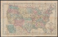
"Entered according to Act of Congress in the year 1856 by Charles Desilver in the clerks office of the District Court of the Eastern District, Also shows proposed western railroad routes., Prime meridians Washington and Greenwich., and Relief shown by hachures.
Publisher:
Charles Desilver,
Subject (Geographic):
United States--Maps
Subject (Name):
Desilver, Charles, Hazzard J. L, and Yeager, E. (Edward)
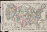
"Entered according to Act of Congress in the year 186[4?] by Charles Desilver in the clerks office of the D, Also shows proposed western railroad routes., Copy 1: Sheet measures 47 x 70 cm., Prime meridians Washington and Greenwich., and Relief shown by hachures.
Publisher:
Charles Desilver,
Subject (Geographic):
United States--Maps
Subject (Name):
Desilver, Charles, Hazzard, J. L, and Yeager, E. (Edward)
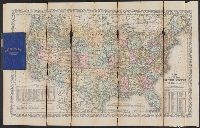
"Entered according to Act of Congress in the year 186[4?] by Charles Desilver in the clerks office of the District Court of the Eastern District of Pe, Includes note and population tables., Prime meridians Washington and Greenwich., and Relief shown by hachures.
Publisher:
Charles Desilver,
Subject (Geographic):
United States--Maps
Subject (Name):
Desilver, Charles, Hazzard, J. L, and Yeager, E. (Edward)
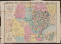
Map showing the proposed route of the Aransas railroad (and its) connections with the eastern roads. and Texas almanac for ...
Description:
"Compiled from government surveys and other authentic documents ... engraved expressly for the Texas almanac.", "Entered according to act of congress in the, Prime meridians: Greenwich and Washington., Relief shown by hachures., and Shows counties and railroads.
Publisher:
Charles Desilver,
Subject (Geographic):
Mexico, North--Maps, Texas--Administrative and political divisions--Maps, and Texas--Maps
Subject (Name):
Desilver, Charles and Richardson, Willard, 1802-1875
Map showing the proposed route of the Aransas railroad (and its) connections with the eastern roads., New map of the state of Texas, including part of Mexico, Richardsons' new map of Texas, State of Texas, including part of Mexico, and Texas almanac for ...
Description:
"Compiled from government surveys and other authentic documents.", "Engraved expressly for the Texas Almanac.", Includes te, and Inset: Map showing the proposed route of the Aransas railroad (and its) connections with the eastern roads. Scale [ca. 1:19,500,000].
Publisher:
Charles Desilver,
Subject (Geographic):
Mexico, North--Maps, Texas--Administrative and political divisions--Maps, and Texas--Maps
Subject (Name):
Desilver, Charles, Richardson, Willard, 1802-1875, and Wickeland, H