Search
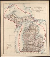
You Searched For
Search Results
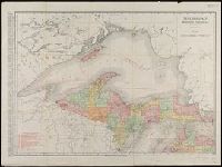
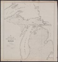
- Creator:
- Rand McNally and Company
- Published / Created:
- 1911
- Call Number:
- 811 1911
- Container / Volume:
- BRBL_00552
- Image Count:
- 2
- Resource Type:
- Maps, Atlases & Globes
- Alternative Title:
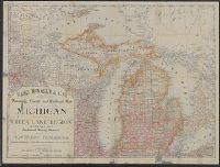
- New business atlas map of Michigan.
- Description:
- new business atlas map of Michigan ; Rand
- Subject (Geographic):
- Michigan--Maps
- Subject (Name):
- Rand McNally and Company. Michigan
- Subject (Topic):
- Railroads--Michigan--Maps
- Found in:
- Beinecke Rare Book and Manuscript Library > Michigan, Southern Peninsula ; Michigan, Northern Peninsula.
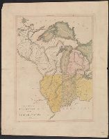
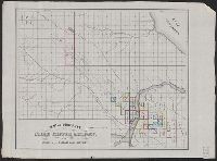
- Creator:
- O.W. Gray & Son
- Published / Created:
- 1876
- Call Number:
- 811 1876
- Container / Volume:
- BRBL_00552
- Image Count:
- 1
- Resource Type:
- Maps, Atlases & Globes
- Description:
- Appears in Michigan Railroad Commission
- Subject (Geographic):
- Michigan--Maps
- Subject (Name):
- Michigan Railroad Commission
- Subject (Topic):
- Railroads--Michigan--Maps
- Found in:
- Beinecke Rare Book and Manuscript Library > Railroad map of Michigan / prepared for the Commissioner of Railroads by O.W. Gray & Son.
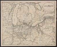
- Published / Created:
- 1900
- Call Number:
- 811 1900
- Container / Volume:
- BRBL_00552
- Image Count:
- 2
- Resource Type:
- Maps, Atlases & Globes
- Description:
- Verso: "Rand, McNally & Co.'s Michigan
- Subject (Geographic):
- Michigan--Maps
- Found in:
- Beinecke Rare Book and Manuscript Library > Rand, McNally & Co.'s Michigan, Southern.
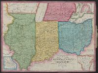
- Published / Created:
- [1810?]
- Call Number:
- 755 1810
- Container / Volume:
- BRBL_00438
- Image Count:
- 1
- Resource Type:
- Maps, Atlases & Globes
- Description:
- Illinois, Indiana, Ohio, Michigan, etc.
- Found in:
- Beinecke Rare Book and Manuscript Library > The Upper Territories of the United States. Kneass & Delleker Sc.
- Published / Created:
- [1910?]
- Call Number:
- 754gme 1910
- Container / Volume:
- BRBL_00420
- Image Count:
- 1
- Resource Type:
- Maps, Atlases & Globes
- Subject (Name):
- Lake Shore & Michigan Southern Railway
- Found in:
- Beinecke Rare Book and Manuscript Library > The Lake Shore & Michigan Southern Railway.
- Published / Created:
- 1853
- Call Number:
- 811 1853
- Container / Volume:
- BRBL_00552
- Image Count:
- 1
- Resource Type:
- Maps, Atlases & Globes
- Description:
- Inset map "Westl. Theil von Michigan."
- Subject (Geographic):
- Michigan--Maps
- Found in:
- Beinecke Rare Book and Manuscript Library > Neueste Karte von Michigan : nach den bessten Quellen bearbeitet.
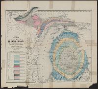
- Creator:
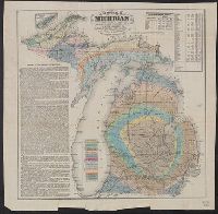
- Winchell, Alexander, 1824-1891
- Published / Created:
- 1873]
- Call Number:
- 811ca 1873
- Container / Volume:
- BRBL_00554
- Image Count:
- 1
- Resource Type:
- Maps, Atlases & Globes
- Description:
- From: Atlas of the state of Michigan
- Subject (Geographic):
- Michigan--Maps
- Subject (Name):
- . Atlas of the state of Michigan
- Subject (Topic):
- Geology--Michigan--Maps
- Found in:
- Beinecke Rare Book and Manuscript Library > Map of the state of Michigan colored to show the geological formations / by Alexander Winchell.
- Published / Created:
- [1831?]
- Call Number:
- 811 1831
- Container / Volume:
- BRBL_00552
- Image Count:
- 1
- Resource Type:
- Maps, Atlases & Globes
- Subject (Geographic):
- Michigan--Maps
- Found in:
- Beinecke Rare Book and Manuscript Library > Michigan.
- Creator:
- Lapham, Charles A., 1857-1935
- Published / Created:
- 1888
- Call Number:
- 812 Oc5 1888
- Container / Volume:
- BRBL_00555A
- Image Count:
- 1
- Resource Type:
- Maps, Atlases & Globes
- Description:
- above Lake Michigan."
- Found in:
- Beinecke Rare Book and Manuscript Library > Map of the lakes & drives in the vicinity of Oconomowoc & Waukesha, Waukesha County, Wisconsin / drawn by Chas. Lapham.
- Creator:
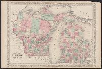
- Johnson, A. J. (Alvin Jewett), 1827-1884
- Published / Created:
- [1866]
- Call Number:
- 812 1866
- Container / Volume:
- BRBL_00555
- Image Count:
- 2
- Resource Type:
- Maps, Atlases & Globes
- Alternative Title:
- Wisconsin and Michigan
- Subject (Geographic):
- Michigan--Maps
- Subject (Topic):
- Counties--Michigan--Maps
- Found in:
- Beinecke Rare Book and Manuscript Library > Johnson's Wisconsin and Michigan.
- Creator:
- Winchell, Alexander, 1824-1891
- Published / Created:
- 1866
- Call Number:
- 811ca 1866
- Container / Volume:
- BRBL_00554
- Image Count:
- 1
- Resource Type:
- Maps, Atlases & Globes
- Description:
- Michigan," population table, and inset of Isle
- Subject (Geographic):
- Michigan--Maps
- Subject (Topic):
- Geology--Michigan--Maps
- Found in:
- Beinecke Rare Book and Manuscript Library > Geological map of Michigan / by Alexander Winchell.
- Creator:
- Rand McNally and Company
- Published / Created:
- 1879
- Call Number:
- 811 1879
- Container / Volume:
- BRBL_00552
- Image Count:
- 1
- Resource Type:
- Maps, Atlases & Globes
- Alternative Title:
- Michigan with a new and original index.
- Subject (Geographic):
- Michigan--Administrative and political
- Subject (Topic):
- Railroads--Michigan--Maps
- Found in:
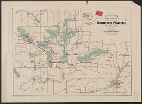
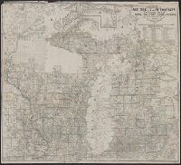
- Beinecke Rare Book and Manuscript Library > Rand, McNally & Co.'s township, county and railroad map of Michigan and the entire Upper Lake Region : showing the celebrated mining districts of the Upper Peninsula / compiled from the U.S. Land Office and Lake Surveys, County Surveys, etc.
- Creator:
- Detroit United Railway
- Published / Created:
- [1900?]
- Call Number:
- 811am D48 1900
- Container / Volume:
- BRBL_00554
- Image Count:
- 2
- Resource Type:
- Maps, Atlases & Globes
- Description:
- interest in southeast Michigan ; chart for
- Subject (Topic):
- Street-railroads--Michigan--Detroit
- Found in:
- Beinecke Rare Book and Manuscript Library > Trolley rides in city and country [cartographic material] : to charming rural scenery, beautiful lakes and majestic rivers via Detroit United Railway.
- Creator:
- Middleton, Strobridge & Co
- Published / Created:
- [1857].
- Call Number:
- 753gme 1858
- Container / Volume:
- BRBL_00415
- Image Count:
- 1
- Resource Type:
- Maps, Atlases & Globes
- Description:
- Mackinaw connecting Lake Michigan and Lake
- Subject (Topic):
- Counties--Michigan--Maps
- Found in:
- Beinecke Rare Book and Manuscript Library > Map illustrating the Canada Pacific and Northern Pacific and other proposed Railroads, connecting at Straits of Mackinaw : Also showing the position of Mackinaw City.
- Published / Created:
- 1844
- Call Number:
- 755 1844
- Container / Volume:
- BRBL_00441
- Image Count:
- 1
- Resource Type:
- Maps, Atlases & Globes
- Description:
- the printed maps of Michigan, 1804-1880
- Found in:
- Beinecke Rare Book and Manuscript Library > Guide through Ohio, Michigan, Indiana, Illinois, Missouri, Wisconsin & Iowa by J. Calvin Smith ...
- Creator:
- Haas, P
- Published / Created:
- 1841]
- Call Number:
- 811fcm 1840
- Container / Volume:
- BRBL_00554
- Image Count:
- 1
- Resource Type:
- Maps, Atlases & Globes
- Description:
- Shows all of Michigan north of Grand
- Subject (Geographic):
- Michigan--Maps
- Found in:
- Beinecke Rare Book and Manuscript Library > Sketch of the public surveys in the north part of Michigan / lith. of P. Haas.
- Creator:
- Noble, Charles
- Published / Created:
- 1850
- Call Number:
- 811fcm 1850
- Container / Volume:
- BRBL_00554
- Image Count:
- 1
- Resource Type:
- Maps, Atlases & Globes
- Subject (Geographic):
- Michigan--Maps
- Found in:
- Beinecke Rare Book and Manuscript Library > Sketch of the public surveys in Michigan / Surveyor General's Office, Detroit, November 12th, 1850, Charles Noble, Surveyor General.
- Creator:
- J.O. Seymour & Co
- Published / Created:
- [ca. 1870]
- Call Number:
- 811gfc P831 1870
- Container / Volume:
- BRBL_00554
- Image Count:
- 1
- Resource Type:
- Maps, Atlases & Globes
- Subject (Topic):
- Copper mines and mining--Michigan
- Found in:
- Beinecke Rare Book and Manuscript Library > Map of property of the Globe Copper Company and mines in the Portage Lake District.
- Published / Created:
- 1855
- Call Number:
- 811ca 1855
- Container / Volume:
- BRBL_00554
- Image Count:
- 1
- Resource Type:
- Maps, Atlases & Globes
- Description:
- United States for the State of Michigan".
- Subject (Geographic):
- Michigan--Maps
- Found in:
- Beinecke Rare Book and Manuscript Library > [Western part of upper peninsula, Michigan].
- Creator:
- Winchell, Alexander, 1824-1891
- Published / Created:
- 1865
- Call Number:
- 811 1865
- Container / Volume:
- BRBL_00552
- Image Count:
- 1
- Resource Type:
- Maps, Atlases & Globes
- Description:
- Inset map showing state of Michigan and
- Subject (Topic):
- Geology--Michigan--Grand Traverse Bay
- Found in:
- Beinecke Rare Book and Manuscript Library > Map of the Grand Traverse region : to accompany a report on its geological & industrial resources / by Alexander Winchell ; drawn by H.G. Rothwell.
- Creator:
- George B. Cadwell & Co
- Published / Created:
- 1892
- Call Number:
- 811 H867 1892
- Container / Volume:
- BRBL_00553
- Image Count:
- 1
- Resource Type:
- Maps, Atlases & Globes
- Description:
- Lenawee County, Michigan. [Adrian, Mich
- Subject (Name):
- Lenawee County, Michigan
- Subject (Topic):
- Real property--Michigan--Hudson--Maps
- Found in:
- Beinecke Rare Book and Manuscript Library > Map of Hudson : compiled expressly for the Lenawee Co. atlas.
- Creator:
- George B. Cadwell & Co
- Published / Created:
- 1893
- Call Number:
- 811 M815 1893
- Container / Volume:
- BRBL_00553
- Image Count:
- 1
- Resource Type:
- Maps, Atlases & Globes
- Description:
- Lenawee County, Michigan. [Adrian, Mich
- Subject (Name):
- Lenawee County, Michigan
- Subject (Topic):
- Real property--Michigan--Morenci--Maps
- Found in:
- Beinecke Rare Book and Manuscript Library > Morenci : compiled & drawn expressly for the Lenawee County atlas.
- Published / Created:
- 1843
- Call Number:
- 811 1843
- Container / Volume:
- BRBL_00552
- Image Count:
- 1
- Resource Type:
- Maps, Atlases & Globes
- Subject (Geographic):
- Michigan--Maps
- Found in:
- Beinecke Rare Book and Manuscript Library > Traveller's map of Michigan, Indiana & Ohio.
- Published / Created:
- [1847]
- Call Number:
- 811fcm 1847
- Container / Volume:
- BRBL_00554
- Image Count:
- 1
- Resource Type:
- Maps, Atlases & Globes
- Subject (Geographic):
- Michigan--Maps
- Found in:
- Beinecke Rare Book and Manuscript Library > Sketch of the Public Surveys in Michigan.
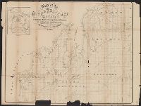
- Published / Created:
- 1837
- Call Number:
- 811 1837
- Container / Volume:
- BRBL_00552
- Image Count:
- 1
- Resource Type:
- Maps, Atlases & Globes
- Subject (Geographic):
- Michigan--Maps
- Found in:
- Beinecke Rare Book and Manuscript Library > The Surveyed Part of Michigan by John Farmer.
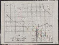
- Published / Created:
- 1880
- Call Number:
- 811 1880
- Container / Volume:
- BRBL_00552
- Image Count:
- 1
- Resource Type:
- Maps, Atlases & Globes
- Subject (Geographic):
- Michigan--Maps
- Found in:
- Beinecke Rare Book and Manuscript Library > Railroad map of Michigan / prepared for the Commissioner of railroads.
- Published / Created:
- 1836
- Call Number:
- 811 1836
- Container / Volume:
- BRBL_00552
- Image Count:
- 1
- Resource Type:
- Maps, Atlases & Globes
- Subject (Geographic):
- Michigan--Maps
- Found in:
- Beinecke Rare Book and Manuscript Library > An improved edition of a map of the survryed part of the Territory of Michigan. by John Farmer
- Creator:
- Roser, C
- Published / Created:
- 1878
- Call Number:
- 811 1878
- Container / Volume:
- BRBL_00552
- Image Count:
- 1
- Resource Type:
- Maps, Atlases & Globes
- Subject (Geographic):
- Michigan--Maps
- Found in:
- Beinecke Rare Book and Manuscript Library > State of Michigan / compiled from the official records of the General Land Office and other sources by C. Roser, principal draughtsman G.L.O.
- Creator:
- United States. General Land Office
- Published / Created:
- 1904
- Call Number:
- 811 1904L
- Container / Volume:
- BRBL_00552
- Image Count:
- 1
- Resource Type:
- Maps, Atlases & Globes
- Subject (Geographic):
- Michigan--Maps
- Found in:
- Beinecke Rare Book and Manuscript Library > State of Michigan / compiled from the official records of the General Land Office and other sources Under the direction of Frank Bond, Chief of Drafting Division, G.L.O. ; revised and drawn by Charles J. Helm.
- Creator:
- George B. Cadwell & Co
- Published / Created:
- 1892
- Call Number:
- 811 T227 1892
- Container / Volume:
- BRBL_00553
- Image Count:
- 1
- Resource Type:
- Maps, Atlases & Globes
- Subject (Name):
- Lenawaee County, Michigan
- Subject (Topic):
- Real property--Michigan--Tecumseh--Maps
- Found in:
- Beinecke Rare Book and Manuscript Library > Map of Tecumseh : compiled for Geo. B. Cadwell & Co's. atlas of Lenawee County, Mich.
- Published / Created:
- 1858
- Call Number:
- 811cea Sa245 1858
- Container / Volume:
- BRBL_00554
- Image Count:
- 1
- Resource Type:
- Maps, Atlases & Globes
- Subject (Geographic):
- Michigan--Maps
- Found in:
- Beinecke Rare Book and Manuscript Library > Channel cut of Middle Channel, Lake George : St. Mary's River improvement showing character of bottom & extent of dredging up to September 30th 1858 / drawn by James T. Baker, surveyed under the orders of Capt. A.W. Whipple, T.E., by J.H. Forster U.S. Sub
- Published / Created:
- 1858
- Call Number:
- 811cea Sa245 1858A
- Container / Volume:
- BRBL_00554
- Image Count:
- 1
- Resource Type:
- Maps, Atlases & Globes
- Subject (Geographic):
- Michigan--Maps
- Found in:
- Beinecke Rare Book and Manuscript Library > Chart of East Neebish rapids, River St. Mary : showing the improved west channel, dredged and surveyed in 1858 under the direction of Capt. A.W. Whipple, T.E. / J.H. Foster U.S. Sub. Agt., James T. Foster, draughtsman.
- Published / Created:
- 1858
- Call Number:
- 811cea Sa245 1858B
- Container / Volume:
- BRBL_00554
- Image Count:
- 1
- Resource Type:
- Maps, Atlases & Globes
- Subject (Geographic):
- Michigan--Maps
- Found in:
- Beinecke Rare Book and Manuscript Library > Tracing of field chart of West Channel of East Neebish rapids : surveyed for the use of the St. Mary's River improvement under the orders of Capt. A.W. Whipple, T.E. / by J.H. Foster U.S. Sub. Agt. May 1858.
- Published / Created:
- [1859?] and [between 1880 and 1889?]
- Call Number:
- BrSides Folio 2018 138
- Image Count:
- 1
- Resource Type:
- Maps, Atlases & Globes
- Subject (Geographic):
- Michigan--Keweenaw County
- Subject (Name):
- Delaware Mining Company of Michigan
- Subject (Topic):
- Copper mines and mining--Michigan
- Found in:
- Beinecke Rare Book and Manuscript Library > Map of a portion of Point Keweenaw, L.S. : showing the lands &c. of the Pennsylvania & Delaware Mining Co's.
- Creator:
- Burr, David H., 1803-1875
- Published / Created:
- [1839?]
- Call Number:
- 811 1839A
- Container / Volume:
- BRBL_00552
- Image Count:
- 4
- Resource Type:
- Maps, Atlases & Globes
- Alternative Title:
- Map of Michigan and part of Wisconsin
- Subject (Geographic):
- Michigan--Maps
- Found in:
- Beinecke Rare Book and Manuscript Library > Map of Michigan & part of Wisconsin Territory : exhibiting the post offices, post roads, canals, rail roads, &c. / by David H. Burr.
- Creator:
- St. Mary's Canal Mineral Land Company
- Published / Created:
- [1859]
- Call Number:
- BrSides Folio 2018 137
- Image Count:
- 1
- Resource Type:
- Maps, Atlases & Globes
- Subject (Geographic):
- Michigan--Upper Peninsula
- Subject (Topic):
- Iron mines and mining--Michigan--Upper
- Found in:
- Beinecke Rare Book and Manuscript Library > Map showing iron mines in vicinity of Marquette, Lake Superior [cartographic material].
- Creator:
- Benton Harbor Improvement Association
- Published / Created:
- 1892?]
- Call Number:
- 811 B44 1892
- Container / Volume:
- BRBL_00553
- Image Count:
- 1
- Resource Type:
- Maps, Atlases & Globes
- Subject (Topic):
- Real property--Michigan--Benton Harbor
- Found in:
- Beinecke Rare Book and Manuscript Library > Benton Harbor : already a manufacturing, railroad and business center, is destined to speedily become one of the great cities of Michigan.
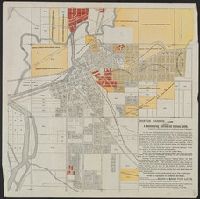
- Creator:
- Phillips, R. C. (Robert C.)
- Published / Created:
- 1857
- Call Number:
- 811 M21 1857
- Collection Title:
- Exposition of the natural position of Mackinaw City.
- Container / Volume:
- BRBL_00553
- Image Count:
- 1
- Resource Type:
- Maps, Atlases & Globes
- Subject (Topic):
- Real property--Michigan--Mackinaw City
- Found in:
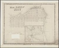
- Beinecke Rare Book and Manuscript Library > Mackinaw City : from actual survey made August 1857 / by R.C. Phillips, surveyor.
- Published / Created:
- 1913
- Call Number:
- 811 D48 1913
- Container / Volume:
- BRBL_00553
- Image Count:
- 1
- Resource Type:
- Maps, Atlases & Globes
- Alternative Title:
- Map of the city of Detroit, Michigan
- Subject (Geographic):
- Detroit (Michigan)--Maps
- Found in:
- Beinecke Rare Book and Manuscript Library > R.L. Polk & Co.'s map of the city of Detroit, Michigan.
- Published / Created:
- 1913
- Call Number:
- 811 D48 1913A
- Container / Volume:
- BRBL_00553
- Image Count:
- 2
- Resource Type:
- Maps, Atlases & Globes
- Subject (Geographic):
- Detroit (Michigan)--Maps
- Found in:
- Beinecke Rare Book and Manuscript Library > Ideal map of the city of Detroit Michigan.
- Creator:
- Farmer, John, 1798-1859
- Published / Created:
- 1857
- Call Number:
- 754 1857
- Container / Volume:
- BRBL_00416
- Image Count:
- 1
- Resource Type:
- Maps, Atlases & Globes
- Alternative Title:
- Township map of Michigan and Wisconsin.
- Subject (Geographic):
- Michigan--Maps
- Found in:
- Beinecke Rare Book and Manuscript Library > Farmer's township map of Michigan and Wisconsin : embracing part of Iowa Illinois and Minnesota, with a chart of the lakes / prepared engraved and published by the author at Detroit.
- Creator:
- Rand McNally and Company
- Published / Created:
- 1899
- Call Number:
- 80gme 1899
- Container / Volume:
- BRBL_00539
- Image Count:
- 1
- Resource Type:
- Maps, Atlases & Globes
- Description:
- Michigan, through South Dakota, Minnesota
- Found in:
- Beinecke Rare Book and Manuscript Library > Chicago, Burlington & Quincy railroad system.
- Published / Created:
- 1914]
- Call Number:
- 80gme 1914B
- Container / Volume:
- BRBL_00540
- Image Count:
- 1
- Resource Type:
- Maps, Atlases & Globes
- Description:
- Shows lines running from Lake Michigan
- Found in:
- Beinecke Rare Book and Manuscript Library > Chicago, Milwaukee & St. Paul Railway Company and subsidiary lines : June 30, 1914.
- Published / Created:
- [1754]
- Call Number:
- 755 1754
- Container / Volume:
- BRBL_00728
- Image Count:
- 1
- Resource Type:
- Maps, Atlases & Globes
- Description:
- west to Lake Michigan.
- Found in:
- Beinecke Rare Book and Manuscript Library > An accurate map of the English colonies in North America, bordering on the river Ohio.
- Creator:
- Lapham, Charles A., 1857-1935
- Published / Created:
- [1874?]
- Call Number:
- 812 Oc5 1890
- Container / Volume:
- BRBL_00555A
- Image Count:
- 1
- Resource Type:
- Maps, Atlases & Globes
- Description:
- above L. Michigan."
- Found in:
- Beinecke Rare Book and Manuscript Library > Map of the lakes & drives around Oconomowoc, Wisconsin : a favorite summer resort / [drawn by Chas. Lapham].
- Published / Created:
- 1915
- Call Number:
- 812ag 1915
- Container / Volume:
- BRBL_00556
- Image Count:
- 2
- Resource Type:
- Maps, Atlases & Globes
- Description:
- northern Wisconsin and Michigan, reached by the
- Subject (Geographic):
- Michigan--Maps
- Found in:
- Beinecke Rare Book and Manuscript Library > Hunting and fishing resorts of northern Wisconsin and Michigan : reached by the Chicago and North Western Railway.
- Creator:
- Endicott & Co. (New York, N.Y.)
- Published / Created:
- [between 1870 and 1879?]
- Call Number:
- BrSides Folio 2018 142
- Image Count:
- 1
- Resource Type:
- Maps, Atlases & Globes
- Subject (Topic):
- Copper mines and mining--Michigan
- Found in:
- Beinecke Rare Book and Manuscript Library > Land of the Seneca Mining Co., Lake Superior, Michigan.
- Creator:
- Bouvé, Ephraim W., 1817-1897
- Published / Created:
- [185-?]
- Call Number:
- 754gme 1850A
- Container / Volume:
- BRBL_00419
- Image Count:
- 1
- Resource Type:
- Maps, Atlases & Globes
- Description:
- of Michigan.
- Found in:
- Beinecke Rare Book and Manuscript Library > Map of the Alton & Springfield railroad, in Illinois : showing its connection with other roads and proposed roads leading to the eastern cities / lith. of E.W. Bouvé.
- Published / Created:
- 1891
- Call Number:
- 75gme 1891A
- Container / Volume:
- BRBL_00414
- Image Count:
- 2
- Resource Type:
- Maps, Atlases & Globes
- Publisher:
- Lake Shore & Michigan Southern Railway,
- Found in:
- Beinecke Rare Book and Manuscript Library > Map of the Lake Shore & Michigan Southern Railway "Lake Shore Route" and Principal Connections / Poole Bros., Map Engravers, Chicago.