Search
You Searched For
Search Results
- Published / Created:
- 1853
- Call Number:
- 811 1853
- Container / Volume:
- BRBL_00552
- Image Count:
- 1
- Resource Type:
- Maps, Atlases & Globes
- Description:
- Inset map "Westl. Theil von Michigan."
- Subject (Geographic):
- Michigan--Maps
- Found in:
- Beinecke Rare Book and Manuscript Library > Neueste Karte von Michigan : nach den bessten Quellen bearbeitet.
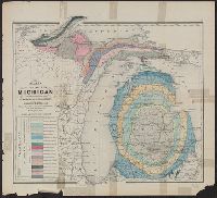
- Creator:
- Winchell, Alexander, 1824-1891
- Published / Created:
- 1873]
- Call Number:
- 811ca 1873
- Container / Volume:
- BRBL_00554
- Image Count:
- 1
- Resource Type:
- Maps, Atlases & Globes
- Description:
- From: Atlas of the state of Michigan
- Subject (Geographic):
- Michigan--Maps
- Subject (Name):
- . Atlas of the state of Michigan
- Subject (Topic):
- Geology--Michigan--Maps
- Found in:
- Beinecke Rare Book and Manuscript Library > Map of the state of Michigan colored to show the geological formations / by Alexander Winchell.
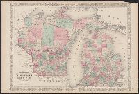
- Creator:
- Johnson, A. J. (Alvin Jewett), 1827-1884
- Published / Created:
- [1866]
- Call Number:
- 812 1866
- Container / Volume:
- BRBL_00555
- Image Count:
- 2
- Resource Type:
- Maps, Atlases & Globes
- Alternative Title:
- Wisconsin and Michigan
- Subject (Geographic):
- Michigan--Maps
- Subject (Topic):
- Counties--Michigan--Maps
- Found in:
- Beinecke Rare Book and Manuscript Library > Johnson's Wisconsin and Michigan.
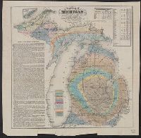
- Creator:
- Winchell, Alexander, 1824-1891
- Published / Created:
- 1866
- Call Number:
- 811ca 1866
- Container / Volume:
- BRBL_00554
- Image Count:
- 1
- Resource Type:
- Maps, Atlases & Globes
- Description:
- Michigan," population table, and inset of Isle
- Subject (Geographic):
- Michigan--Maps
- Subject (Topic):
- Geology--Michigan--Maps
- Found in:
- Beinecke Rare Book and Manuscript Library > Geological map of Michigan / by Alexander Winchell.
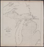
- Creator:
- Middleton, Strobridge & Co
- Published / Created:
- [1857].
- Call Number:
- 753gme 1858
- Container / Volume:
- BRBL_00415
- Image Count:
- 1
- Resource Type:
- Maps, Atlases & Globes
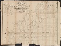
- Description:
- Mackinaw connecting Lake Michigan and Lake
- Subject (Topic):
- Counties--Michigan--Maps
- Found in:
- Beinecke Rare Book and Manuscript Library > Map illustrating the Canada Pacific and Northern Pacific and other proposed Railroads, connecting at Straits of Mackinaw : Also showing the position of Mackinaw City.
- Creator:
- Noble, Charles
- Published / Created:
- 1850
- Call Number:
- 811fcm 1850
- Container / Volume:
- BRBL_00554
- Image Count:
- 1
- Resource Type:
- Maps, Atlases & Globes
- Subject (Geographic):
- Michigan--Maps
- Found in:
- Beinecke Rare Book and Manuscript Library > Sketch of the public surveys in Michigan / Surveyor General's Office, Detroit, November 12th, 1850, Charles Noble, Surveyor General.
- Creator:
- J.O. Seymour & Co
- Published / Created:
- [ca. 1870]
- Call Number:
- 811gfc P831 1870
- Container / Volume:
- BRBL_00554
- Image Count:
- 1
- Resource Type:
- Maps, Atlases & Globes
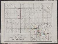
- Subject (Topic):
- Copper mines and mining--Michigan
- Found in:
- Beinecke Rare Book and Manuscript Library > Map of property of the Globe Copper Company and mines in the Portage Lake District.
- Creator:
- J.O. Seymour & Co
- Published / Created:
- [ca. 1870]
- Call Number:
- 811gfc P831 1870
- Container / Volume:
- BRBL_00554
- Image Count:
- 1
- Resource Type:
- Maps, Atlases & Globes
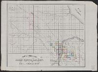
- Subject (Topic):
- Copper mines and mining--Michigan
- Found in:
- Beinecke Rare Book and Manuscript Library > Map of property of the Globe Copper Company and mines in the Portage Lake District.
- Published / Created:
- 1855
- Call Number:
- 811ca 1855
- Container / Volume:
- BRBL_00554
- Image Count:
- 1
- Resource Type:
- Maps, Atlases & Globes
- Description:
- United States for the State of Michigan".
- Subject (Geographic):
- Michigan--Maps
- Found in:
- Beinecke Rare Book and Manuscript Library > [Western part of upper peninsula, Michigan].
- Creator:
- Winchell, Alexander, 1824-1891
- Published / Created:
- 1865
- Call Number:
- 811 1865
- Container / Volume:
- BRBL_00552
- Image Count:
- 1
- Resource Type:
- Maps, Atlases & Globes
- Description:
- Inset map showing state of Michigan and
- Subject (Topic):
- Geology--Michigan--Grand Traverse Bay
- Found in:
- Beinecke Rare Book and Manuscript Library > Map of the Grand Traverse region : to accompany a report on its geological & industrial resources / by Alexander Winchell ; drawn by H.G. Rothwell.