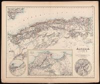
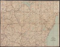
Algérie, Algiers and environs on an enlarged scale., Constantine and environs., and Oran and environs.
Description:
Appears in: Royal illustrated atlas of modern geography. London ; Edinburgh : A. Fullarton and Co., [1872?]. (pl. XLVI)., Inset maps: 1. Algiers and environs on an enlarged scale. Scale [ca. 1:1,050,000] -- 2. Constantine and environs -- 3. Oran and environs., Relief shown by hachures., and Stamp in upper right corner: 46.
Publisher:
A. Fullarton and Co.,
Subject (Geographic):
Algeria--Maps.
Subject (Name):
A. Fullarton & Co., A. Fullarton & Co. Royal illustrated atlas of modern geography., and Edward Stanford Ltd.
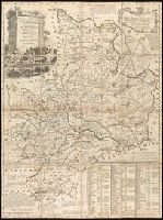
Appears in various eds. of Atlas geographicus maior., Includes German text relating to English and French territorial claims., Place names and descriptive notes in English., Prime meridian: Ferro and London., Relief shown pictorially., and Sheet measures 47.5 x 51 cm.
Publisher:
[Homann Erben],
Subject (Geographic):
North America--Maps--Early works to 1800. and United States--History--French and Indian War, 1755-1763--Maps--Early works to 1800.
Subject (Name):
Anville, Jean Baptiste Bourguignon d', 1697-1782. and Homann Erben (Firm). Atlas geographicus maior.
Appears in various eds. of Atlas geographicus maior., Includes German text relating to English and French territorial claims., Place names and descriptive notes in English., Prime meridian: Ferro and London., and Relief shown pictorially.
Publisher:
[s.n.],
Subject (Geographic):
North America--Maps--Early works to 1800. and United States--History--French and Indian War, 1755-1763--Maps--Early works to 1800.
Subject (Name):
Anville, Jean Baptiste Bourguignon d', 1697-1782. and Homann Erben (Firm). Atlas geographicus maior.
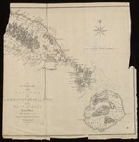
From his atlas Prospect of the World, pp. 9-10, sig. e, catch. in-., Includes text, inset of Greenland, and views of towns and ill. of figures in margins., Text of "The description of America" on verso., and Tooley identifies this as a 1676 issue, noting NY and Maryland mentioned for the first time in text about Virginia (section 14) on verso; and Hochelaga, Quebec, and Tadasac added to description of Canada.
Publisher:
are to be sold by Thomas Bassett in Fleet Street and by Richard Chiswell in St. Pauls Churchyard,
Subject (Geographic):
America--Maps--Early works to 1800.
Subject (Name):
Bassett, Thomas, bookseller., Chiswell, Richard., Goos, Abraham, engraver., and Speed, John, 1552?-1629. Prospect of the most famous parts of the world.
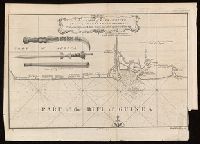
Coordinates not present on map and are approximated., From A new general collection of voyages and travels (London, 1745-47)., Includes illustrations of "weapons used by the Hakbous blacks.", Lower left: "No. 87.", Lower right: "Plate X, Vol. III, p. 105.", and Stamps: Glasgow Public Libraries.
Publisher:
[publisher not identified],
Subject (Geographic):
Cross River State (Nigeria)--Maps--Early works to 1800.
Subject (Name):
Child, G., engraver. and Glasgow (Scotland). Public Libraries Stamp.
Subject (Topic):
Coasts--Nigeria--Calabar Province--Maps--Early works to 1800.
Concentric rings at one mile intervals from Huntingdon., Dedicated to the Robert Montagu, Duke of Manchester., Imperfect: edges trimmed, with loss of imprint information. Dissected and mounted on linen. In cover with label "17 Huntingdonshire.", Notes about the county; includes "Index Villaris.", Prime meridian: London., Relief shown by hachures., and Shows boundaries, roads, woods, parks and settlements.
Publisher:
[Emanuel Bowen?],
Subject (Geographic):
Huntingdonshire (England)--Early works to 1800--Maps.
Subject (Name):
Bowles, John, 1701-1779, publisher. and Hinton, John, -1781, bookseller.
"European Magazine" in upper right., Coordinates not present on map and are approximated., Imperfect: left portion of map and upper right portion of map wanting, with some loss of text., Relief shown pictorially., and Watermark.
Publisher:
Published April 1, 1782, by I. Fielding, Pater noster Row, J. Sewell, Cornhill, and J. Debrett, Piccadilly,
Automobile map of New Hampshire, central and Automobile map of New Hampshire, south
Description:
Automobile map of New Hampshire, south, No. 13 -- Automobile map of New Hampshire central, No. 14., Maps mounted on cloth backing., Relief shown by hachures., Shows southeastern New Hampshire and some of Maine and Massachusetts, from Saco, Me. in the northeast to Newbury, Mass. in the southeast and Orange, N.H. in the northwest to Rindge, N.H. in the southwest., and Title from panel.