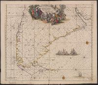
Series B, Wind and current charts, Wind and current chart, Wind and current chart, trade wind chart of the Atlantic Ocean, Wind and current charts, Wind and current charts, trade wind chart of the Atlantic Ocean, and Wind and current charts.
Description:
"Lith. of J. Bien. 180 Broadway. N.Y."
Publisher:
s.n.],
Subject (Geographic):
Atlantic Ocean--Maps
Subject (Name):
Dehaven, E. J, Maury, Matthew Fontaine, 1802-1873. Wind and current charts, and United States. Bureau of Ordnance and Hydrography
Subject (Topic):
Nautical charts--Atlantic Ocean, Trade winds--Atlantic Ocean--Maps, and Winds--Atlantic Ocean--Maps
[Maury map collection ; ser. B1], Atlantic Ocean, and Wind and current charts
Description:
The trade wind charts were released as series B a part of Maury's "Wind and current charts", series A-F. Two sheets were produced, one for the Atlantic and the other for the Indian Ocean. For complete discussion, see "The wind and current chart series...
Publisher:
United States Hydrographical Office],
Subject (Geographic):
Atlantic Ocean--Charts, diagrams, etc
Subject (Name):
Dehaven, E. J, Maury, Matthew Fontaine, 1806-1873. Wind and current charts, Morris, Charles, 1784-1856, United States Naval Observatory, United States. Bureau of Ordnance and Hydrography, and United States. Hydrographic Office
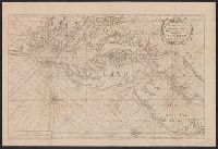
English pilot. Book 4. and Virginia, Maryland, Pennsylvania, east & west New Jersey
Description:
Appears in various eds. of The English pilot, Book 4.
Publisher:
Sold by William Mount & Tho. Page, Tower Hill,
Subject (Geographic):
Middle Atlantic States--Maps--Early works to 1800
Subject (Name):
Mount, William, d. 1769, bookseller and Page, Thomas, d. 1733, bookseller
Subject (Topic):
Coasts--Middle Atlantic States--Maps--Early works to 1800, Nautical charts--Atlantic Coast (Middle Atlantic States)--Early works to 1800, and Nautical charts--Middle Atlantic States--Early works to 1800
English pilot. Book 4. and Virginia, Maryland, Pennsylvania, east & west New Jersey
Description:
From The English pilot, Book 4 ... Dublin : Geo. Grierson, 1749 (and possibly earlier and later editions); copied from the London editions.
Publisher:
Sold by Geo. Grierson at the Two Bibles in Essex Street,
Subject (Name):
Grierson, George, bookseller
Subject (Topic):
Coasts--Middle Atlantic States--Maps--Early works to 1800, Nautical charts--Atlantic Coast (Middle Atlantic States)--Early works to 1800, and Nautical charts--Middle Atlantic States--Early works to 1800
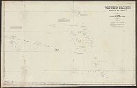
Imray, James F. (James Frederick), 1829?-1891, cartographer James Imray and Son, issuing body
Call Number:
23cea 1886
Container / Volume:
BRBL_00021
Image Count:
2
Resource Type:
Maps, Atlases & Globes
Alternative Title:
Western Pacific, sheet no. 4
Description:
Hydrographic chart of the western Pacific Ocean, including eastern Australia, Papua New Guinea, the Solomon Islands, New Hebrides, New Caledonia, and the northwest of New Zealand.
Subject (Geographic):
Melanesia--Maps and Pacific Ocean--Maps
Subject (Topic):
Nautical charts--Melanesia and Nautical charts--Pacific Ocean
Bien, Julius, 1826-1909, Maury, William L, Perry, Matthew Calbraith, 1794-1858, Sels, Edward, Siebert, Selmar, and United States Naval Expedition to Japan--1852-1854